Çaldıran elevation
Çaldıran (Van), Turkey elevation is 2050 meters and Çaldıran elevation in feet is 6726 ft above sea level [src 1]. Çaldıran is a seat of a second-order administrative division (feature code) with elevation that is 1327 meters (4354 ft) bigger than average city elevation in Turkey.
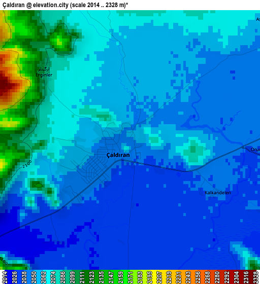
Below is the Elevation map of Çaldıran, which displays elevation range with different colors. Scale of the first map is from 2014 to 2328 m (6608 to 7638 ft) with average elevation of 2060.1 meters (=6759 ft) [note 1]
These maps also provides idea of topography and contour of this city, they are displayed at different zoom levels. More info about maps, scale and edge coordinates you can find below images.
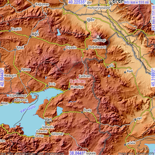
| \ | Map #1 | Topo.Map |
| Scale [m] | 2014..2328 m | × |
| Scale [ft] | 6608..7638 ft | × |
| Average | 2060.1 m = 6759 ft | × |
| Width | 7.58 km = 4.7 mi | 242.5 km = 150.7 mi |
| Height | 7.58 km = 4.7 mi | 242.5 km = 150.7 mi |
| ↑Max Latitude | 39.177244° | 40.22535° |
| Latitude at center | 39.14317° | 39.14317° |
| ↓Min Latitude | 39.109079° | 38.0441° |
| ← Min Longitude | 43.866735° | 42.50443° |
| Longitude center | 43.91068° | 43.91068° |
| →Max Longitude | 43.954625° | 45.31693° |
Nearby cities:
Cities around Çaldıran sort by population:
• Erciş elevation 1682 m
49.3 km,  254°
254°
• Doğubayazıt 1592 m
47.3 km,  18°
18°
• Diyadin 1928 m
48.7 km,  335°
335°
• Özalp 1985 m
54.7 km,  172°
172°
• Kocapınar 1788 m
61.9 km,  265°
265°
• Suluçem 1750 m
61.8 km,  352°
352°
• Erçek 1806 m
59.4 km,  202°
202°
• Saray 2069 m
59.3 km,  158°
158°
• Timar 1773 m
54.1 km,  229°
229°
• Dorutay 2034 m
40.6 km, 160°
• Deliçay 1929 m
37.3 km,  259°
259°
• Muradiye 1683 m
22.2 km,  217°
217°
Multilingual:
 En español:
Çaldıran elevación 2050 m.
 En France:
Çaldıran élévation 2050 m.
 Auf Deutsch:
Çaldıran höhe über dem Meeresspiegel ist 2050 m.

Sources and notes:
- [note 1] Map square and city borders are not equal. Map elevation data is calculated only from area inside that square.
- [src 1] Elevation data from geonames database provided with same terms of usage.
- [src 2] The elevation map of Çaldıran is generated using elevation data from NASA's 3 arcsec (90m) resolution SRTM data.
- [src 3] Base (background) map © OpenStreetMap contributors tiles are generated by Geofabrik and OpenTopoMap.
Copyright & License:
This Çaldıran Elevation Map is licensed under CC BY-SA. You may reuse any part from this page, if you give a proper credit by linking to this URL:
 More info on terms of use page.