Devecikonağı elevation
Devecikonağı (Bursa), Turkey elevation is 67 meters and Devecikonağı elevation in feet is 220 ft above sea level [src 1]. Devecikonağı is a seat of a third-order administrative division (feature code) with elevation that is 656 meters (2152 ft) smaller than average city elevation in Turkey.
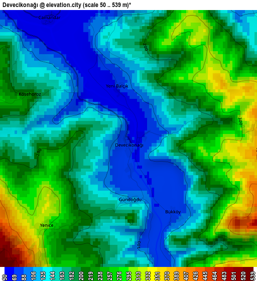
Below is the Elevation map of Devecikonağı, which displays elevation range with different colors. Scale of the first map is from 50 to 539 m (164 to 1768 ft) with average elevation of 189.9 meters (=623 ft) [note 1]
These maps also provides idea of topography and contour of this city, they are displayed at different zoom levels. More info about maps, scale and edge coordinates you can find below images.
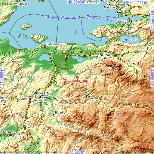
| \ | Map #1 | Topo.Map |
| Scale [m] | 50..539 m | × |
| Scale [ft] | 164..1768 ft | × |
| Average | 189.9 m = 623 ft | × |
| Width | 7.5 km = 4.7 mi | 239.9 km = 149.1 mi |
| Height | 7.5 km = 4.7 mi | 239.8 km = 149 mi |
| ↑Max Latitude | 39.948558° | 40.98494° |
| Latitude at center | 39.91486° | 39.91486° |
| ↓Min Latitude | 39.881146° | 38.8278° |
| ← Min Longitude | 28.517815° | 27.15551° |
| Longitude center | 28.56176° | 28.56176° |
| →Max Longitude | 28.605705° | 29.96801° |
Nearby cities:
Cities around Devecikonağı sort by population:
• Mustafakemalpaşa elevation 25 m
18.9 km,  316°
316°
• Susurluk 55 m
34.5 km,  269°
269°
• Dursunbey 658 m
37 km,  171°
171°
• Orhaneli 515 m
36.6 km,  92°
92°
• Yenice 769 m
34.1 km,  120°
120°
• Tatkavaklı 36 m
21.2 km,  308°
308°
• Karıncalı 428 m
26.1 km,  76°
76°
• Durak 528 m
33.9 km,  226°
226°
• Büyükorhan 804 m
32 km, 120°
• Kavacık 713 m
27.2 km,  192°
192°
• Soldere 254 m
16.3 km,  3°
3°
• Çaltılıbük 81 m
5.6 km,  34°
34°
Multilingual:
 En español:
Devecikonağı elevación 67 m.
 En France:
Devecikonağı élévation 67 m.
 Auf Deutsch:
Devecikonağı höhe über dem Meeresspiegel ist 67 m.

Sources and notes:
- [note 1] Map square and city borders are not equal. Map elevation data is calculated only from area inside that square.
- [src 1] Elevation data from geonames database provided with same terms of usage.
- [src 2] The elevation map of Devecikonağı is generated using elevation data from NASA's 3 arcsec (90m) resolution SRTM data.
- [src 3] Base (background) map © OpenStreetMap contributors tiles are generated by Geofabrik and OpenTopoMap.
Copyright & License:
This Devecikonağı Elevation Map is licensed under CC BY-SA. You may reuse any part from this page, if you give a proper credit by linking to this URL:
 More info on terms of use page.