Ezine elevation
Ezine (Canakkale), Turkey elevation is 49 meters and Ezine elevation in feet is 161 ft above sea level [src 1]. Ezine is a seat of a second-order administrative division (feature code) with elevation that is 674 meters (2211 ft) smaller than average city elevation in Turkey.
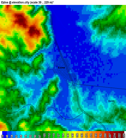
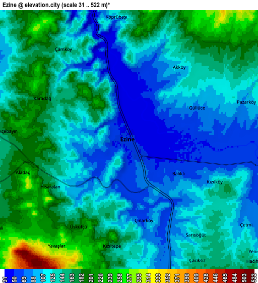
Below is the Elevation map of Ezine, which displays elevation range with different colors. Scale of the first map is from 39 to 229 m (128 to 751 ft) with average elevation of 83.6 meters (=274 ft) [note 1]
These maps also provides idea of topography and contour of this city, they are displayed at different zoom levels. More info about maps, scale and edge coordinates you can find below images.
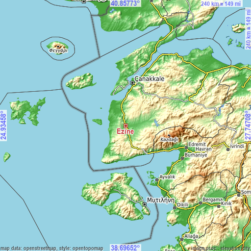
| \ | Map #1 | Map #2 | Topo.Map |
| Scale [m] | 39..229 m | 31..522 m | × |
| Scale [ft] | 128..751 ft | 102..1713 ft | × |
| Average | 83.6 m = 274 ft | 135.6 m = 445 ft | × |
| Width | 7.51 km = 4.7 mi | 15.02 km = 9.3 mi | 240.3 km = 149.3 mi |
| Height | 7.51 km = 4.7 mi | 15.02 km = 9.3 mi | 240.3 km = 149.3 mi |
| ↑Max Latitude | 39.819371° | 39.853116° | 40.85773° |
| Latitude at center | 39.78561° | 39.78561° | 39.78561° |
| ↓Min Latitude | 39.751832° | 39.718038° | 38.69652° |
| ← Min Longitude | 26.296885° | 26.252939° | 24.93458° |
| Longitude center | 26.34083° | 26.34083° | 26.34083° |
| →Max Longitude | 26.384775° | 26.428721° | 27.74708° |
Nearby cities:
Cities around Ezine sort by population:
• Altınoluk elevation 120 m
40.9 km,  124°
124°
• Ayvacık 273 m
21.2 km,  165°
165°
• Geyikli 51 m
11.6 km,  280°
280°
• Bozcaada 12 m
23.8 km, 283°
• Behram 150 m
32.5 km,  181°
181°
• Merkez 11 m
38.8 km,  10°
10°
• Evciler 242 m
36.8 km,  91°
91°
• Küçükkuyu 14 m
34.7 km,  139°
139°
• Gülpınar 149 m
33.8 km,  213°
213°
• İntepe 184 m
25.3 km,  358°
358°
• Yiğitler 174 m
24.8 km,  68°
68°
• Bayramiç 107 m
23.1 km,  83°
83°
Multilingual:
 En español:
Ezine elevación 49 m.
 En France:
Ezine élévation 49 m.


Sources and notes:
- [note 1] Map square and city borders are not equal. Map elevation data is calculated only from area inside that square.
- [src 1] Elevation data from geonames database provided with same terms of usage.
- [src 2] The elevation map of Ezine is generated using elevation data from NASA's 3 arcsec (90m) resolution SRTM data.
- [src 3] Base (background) map © OpenStreetMap contributors tiles are generated by Geofabrik and OpenTopoMap.
Copyright & License:
This Ezine Elevation Map is licensed under CC BY-SA. You may reuse any part from this page, if you give a proper credit by linking to this URL:
 More info on terms of use page.