Genç elevation
Genç (Bingöl), Turkey elevation is 1015 meters and Genç elevation in feet is 3330 ft above sea level [src 1]. Genç is a seat of a second-order administrative division (feature code) with elevation that is 292 meters (958 ft) bigger than average city elevation in Turkey.
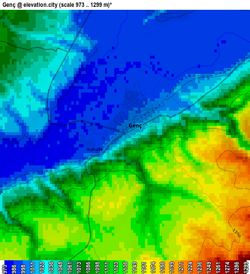
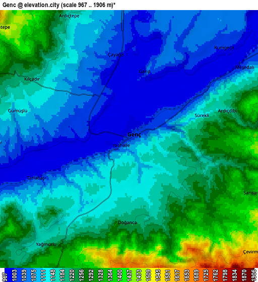
Below is the Elevation map of Genç, which displays elevation range with different colors. Scale of the first map is from 973 to 1299 m (3192 to 4262 ft) with average elevation of 1068.5 meters (=3506 ft) [note 1]
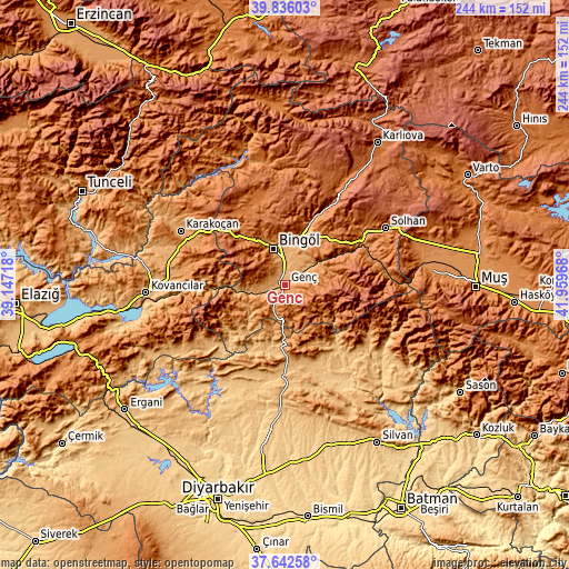
These maps also provides idea of topography and contour of this city, they are displayed at different zoom levels. More info about maps, scale and edge coordinates you can find below images.
| \ | Map #1 | Map #2 | Topo.Map |
| Scale [m] | 973..1299 m | 967..1906 m | × |
| Scale [ft] | 3192..4262 ft | 3173..6253 ft | × |
| Average | 1068.5 m = 3506 ft | 1170.8 m = 3841 ft | × |
| Width | 7.62 km = 4.7 mi | 15.24 km = 9.5 mi | 243.9 km = 151.6 mi |
| Height | 7.62 km = 4.7 mi | 15.24 km = 9.5 mi | 243.9 km = 151.6 mi |
| ↑Max Latitude | 38.781995° | 38.816244° | 39.83603° |
| Latitude at center | 38.74773° | 38.74773° | 38.74773° |
| ↓Min Latitude | 38.713448° | 38.67915° | 37.64258° |
| ← Min Longitude | 40.509485° | 40.465539° | 39.14718° |
| Longitude center | 40.55343° | 40.55343° | 40.55343° |
| →Max Longitude | 40.597375° | 40.641321° | 41.95968° |
Nearby cities:
Cities around Genç sort by population:
• Bingöl elevation 1158 m
16.1 km,  341°
341°
• Lice 979 m
33 km,  167°
167°
• Hani 886 m
40.5 km,  201°
201°
• Ağaçlı 1124 m
39.8 km,  130°
130°
• Yenibaşak 1590 m
38.5 km,  80°
80°
• Gökdere 1179 m
29.9 km,  268°
268°
• Servi 1029 m
28.3 km,  225°
225°
• Yenisu 1697 m
28 km,  89°
89°
• Ilıcalar 1168 m
27.9 km,  21°
21°
• Yayla 1308 m
13.2 km,  189°
189°
• Söğütlü 1204 m
11.6 km,  59°
59°
• Yamaç 1458 m
10.4 km,  287°
287°
Multilingual:
 En español:
Genç elevación 1015 m.
 En France:
Genç élévation 1015 m.


Sources and notes:
- [note 1] Map square and city borders are not equal. Map elevation data is calculated only from area inside that square.
- [src 1] Elevation data from geonames database provided with same terms of usage.
- [src 2] The elevation map of Genç is generated using elevation data from NASA's 3 arcsec (90m) resolution SRTM data.
- [src 3] Base (background) map © OpenStreetMap contributors tiles are generated by Geofabrik and OpenTopoMap.
Copyright & License:
This Genç Elevation Map is licensed under CC BY-SA. You may reuse any part from this page, if you give a proper credit by linking to this URL:
 More info on terms of use page.