Gevaş elevation
Gevaş (Van), Turkey elevation is 1722 meters and Gevaş elevation in feet is 5650 ft above sea level [src 1]. Gevaş is a seat of a second-order administrative division (feature code) with elevation that is 999 meters (3278 ft) bigger than average city elevation in Turkey.
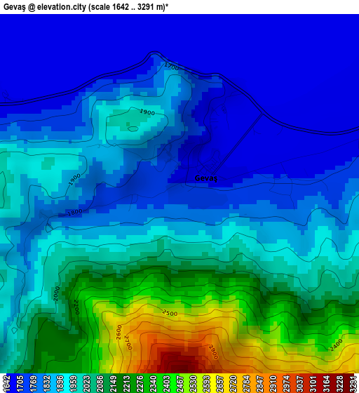
Below is the Elevation map of Gevaş, which displays elevation range with different colors. Scale of the first map is from 1642 to 3291 m (5387 to 10797 ft) with average elevation of 1947.8 meters (=6390 ft) [note 1]
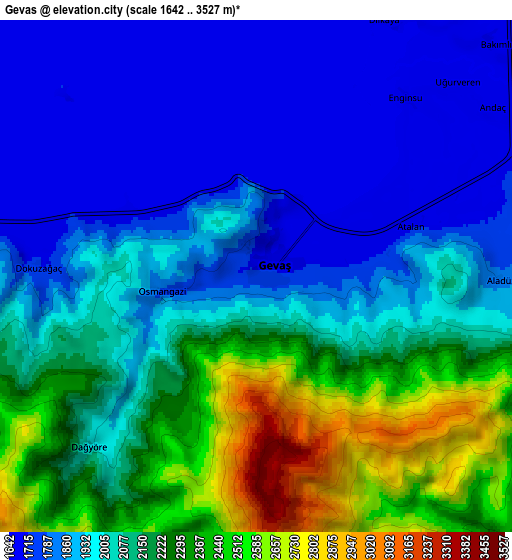
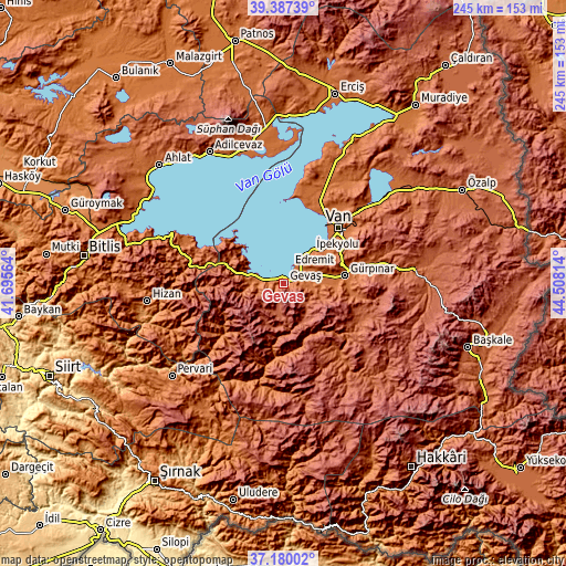
These maps also provides idea of topography and contour of this city, they are displayed at different zoom levels. More info about maps, scale and edge coordinates you can find below images.
| \ | Map #1 | Map #2 | Topo.Map |
| Scale [m] | 1642..3291 m | 1642..3527 m | × |
| Scale [ft] | 5387..10797 ft | 5387..11572 ft | × |
| Average | 1947.8 m = 6390 ft | 2054.9 m = 6742 ft | × |
| Width | 7.67 km = 4.8 mi | 15.34 km = 9.5 mi | 245.4 km = 152.5 mi |
| Height | 7.67 km = 4.8 mi | 15.34 km = 9.5 mi | 245.4 km = 152.5 mi |
| ↑Max Latitude | 38.326583° | 38.361049° | 39.38739° |
| Latitude at center | 38.2921° | 38.2921° | 38.2921° |
| ↓Min Latitude | 38.257601° | 38.223085° | 37.18002° |
| ← Min Longitude | 43.057945° | 43.013999° | 41.69564° |
| Longitude center | 43.10189° | 43.10189° | 43.10189° |
| →Max Longitude | 43.145835° | 43.189781° | 44.50814° |
Nearby cities:
Cities around Gevaş sort by population:
• Van elevation 1708 m
33.3 km,  47°
47°
• Edremit 1699 m
19.8 km,  43°
43°
• Bahçesaray 1751 m
32.4 km,  234°
234°
• Beğendik 1103 m
53 km, 228°
• Konalga 1937 m
48 km,  180°
180°
• Akşar 1576 m
54.1 km,  246°
246°
• Reşadiye 1670 m
54 km,  293°
293°
• Simos 1684 m
52.3 km,  240°
240°
• Narlı 1652 m
46.6 km,  193°
193°
• Kırkgeçit 2087 m
38.4 km,  116°
116°
• Çatak 1836 m
32.4 km, 187°
• Gürpınar 1748 m
27.1 km,  82°
82°
Multilingual:
 En español:
Gevaş elevación 1722 m.
 En France:
Gevaş élévation 1722 m.


Sources and notes:
- [note 1] Map square and city borders are not equal. Map elevation data is calculated only from area inside that square.
- [src 1] Elevation data from geonames database provided with same terms of usage.
- [src 2] The elevation map of Gevaş is generated using elevation data from NASA's 3 arcsec (90m) resolution SRTM data.
- [src 3] Base (background) map © OpenStreetMap contributors tiles are generated by Geofabrik and OpenTopoMap.
Copyright & License:
This Gevaş Elevation Map is licensed under CC BY-SA. You may reuse any part from this page, if you give a proper credit by linking to this URL:
 More info on terms of use page.