Girmeli elevation
Girmeli (Mardin), Turkey elevation is 498 meters and Girmeli elevation in feet is 1634 ft above sea level [src 1]. Girmeli is a seat of a third-order administrative division (feature code) with elevation that is 225 meters (738 ft) smaller than average city elevation in Turkey.
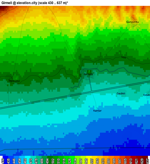
Below is the Elevation map of Girmeli, which displays elevation range with different colors. Scale of the first map is from 430 to 637 m (1411 to 2090 ft) with average elevation of 493.9 meters (=1620 ft) [note 1]
These maps also provides idea of topography and contour of this city, they are displayed at different zoom levels. More info about maps, scale and edge coordinates you can find below images.
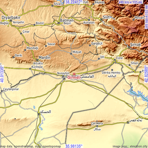
| \ | Map #1 | Topo.Map |
| Scale [m] | 430..637 m | × |
| Scale [ft] | 1411..2090 ft | × |
| Average | 493.9 m = 1620 ft | × |
| Width | 7.79 km = 4.8 mi | 249.4 km = 155 mi |
| Height | 7.79 km = 4.8 mi | 249.4 km = 155 mi |
| ↑Max Latitude | 37.146097° | 38.22417° |
| Latitude at center | 37.11106° | 37.11106° |
| ↓Min Latitude | 37.076007° | 35.98135° |
| ← Min Longitude | 41.375655° | 40.01335° |
| Longitude center | 41.4196° | 41.4196° |
| →Max Longitude | 41.463545° | 42.82585° |
Nearby cities:
Cities around Girmeli sort by population:
• Nusaybin elevation 476 m
18.7 km,  255°
255°
• Duruca 478 m
9.9 km, 258°
• Serkan 609 m
29 km,  79°
79°
• Yayvantepe 912 m
23 km,  22°
22°
• Toptepe 952 m
22.5 km,  317°
317°
• Sivrice 953 m
19.9 km,  338°
338°
• Telminar 502 m
3.2 km,  270°
270°
• Tepealtı 472 m
4.8 km,  249°
249°
• Kayalıpınar 788 m
29.7 km,  325°
325°
• Seri 967 m
29.6 km, 339°
• Özbek 606 m
25.3 km,  73°
73°
• Haberli 963 m
27.8 km,  39°
39°
Multilingual:
 En español:
Girmeli elevación 498 m.
 En France:
Girmeli élévation 498 m.


Sources and notes:
- [note 1] Map square and city borders are not equal. Map elevation data is calculated only from area inside that square.
- [src 1] Elevation data from geonames database provided with same terms of usage.
- [src 2] The elevation map of Girmeli is generated using elevation data from NASA's 3 arcsec (90m) resolution SRTM data.
- [src 3] Base (background) map © OpenStreetMap contributors tiles are generated by Geofabrik and OpenTopoMap.
Copyright & License:
This Girmeli Elevation Map is licensed under CC BY-SA. You may reuse any part from this page, if you give a proper credit by linking to this URL:
 More info on terms of use page.