Gölgelikonak elevation
Gölgelikonak (Siirt), Turkey elevation is 814 meters and Gölgelikonak elevation in feet is 2671 ft above sea level [src 1]. Gölgelikonak is a populated place (feature code) with elevation that is 91 meters (299 ft) bigger than average city elevation in Turkey.
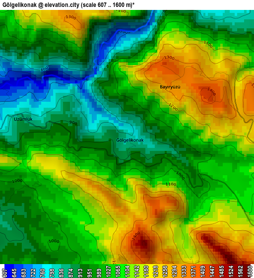
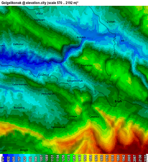
Below is the Elevation map of Gölgelikonak, which displays elevation range with different colors. Scale of the first map is from 607 to 1600 m (1991 to 5249 ft) with average elevation of 1050.9 meters (=3448 ft) [note 1]
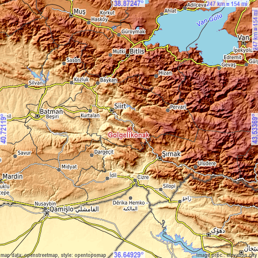
These maps also provides idea of topography and contour of this city, they are displayed at different zoom levels. More info about maps, scale and edge coordinates you can find below images.
| \ | Map #1 | Map #2 | Topo.Map |
| Scale [m] | 607..1600 m | 570..2192 m | × |
| Scale [ft] | 1991..5249 ft | 1870..7192 ft | × |
| Average | 1050.9 m = 3448 ft | 1129 m = 3704 ft | × |
| Width | 7.72 km = 4.8 mi | 15.45 km = 9.6 mi | 247.2 km = 153.6 mi |
| Height | 7.73 km = 4.8 mi | 15.45 km = 9.6 mi | 247.2 km = 153.6 mi |
| ↑Max Latitude | 37.80396° | 37.838673° | 38.87247° |
| Latitude at center | 37.76923° | 37.76923° | 37.76923° |
| ↓Min Latitude | 37.734484° | 37.699721° | 36.64929° |
| ← Min Longitude | 42.083495° | 42.039549° | 40.72119° |
| Longitude center | 42.12744° | 42.12744° | 42.12744° |
| →Max Longitude | 42.171385° | 42.215331° | 43.53369° |
Nearby cities:
Cities around Gölgelikonak sort by population:
• Siirt elevation 893 m
24.2 km,  317°
317°
• Eruh 1215 m
5.1 km,  126°
126°
• Tillo 1199 m
22.4 km,  333°
333°
• Civankan 928 m
26.5 km,  304°
304°
• Doğanca 1367 m
18.2 km,  79°
79°
• Palamutlu 1396 m
15.5 km,  25°
25°
• Lodi 976 m
19.7 km,  251°
251°
• Taşlı 870 m
24.2 km,  1°
1°
• Serhatta 1218 m
11.9 km,  174°
174°
• Okçular 1471 m
27.7 km,  96°
96°
• Fındık 1130 m
31.9 km,  206°
206°
• Özpınar 1580 m
28.1 km,  21°
21°
Multilingual:
 En español:
Gölgelikonak elevación 814 m.
 En France:
Gölgelikonak élévation 814 m.
 Auf Deutsch:
Gölgelikonak höhe über dem Meeresspiegel ist 814 m.

Sources and notes:
- [note 1] Map square and city borders are not equal. Map elevation data is calculated only from area inside that square.
- [src 1] Elevation data from geonames database provided with same terms of usage.
- [src 2] The elevation map of Gölgelikonak is generated using elevation data from NASA's 3 arcsec (90m) resolution SRTM data.
- [src 3] Base (background) map © OpenStreetMap contributors tiles are generated by Geofabrik and OpenTopoMap.
Copyright & License:
This Gölgelikonak Elevation Map is licensed under CC BY-SA. You may reuse any part from this page, if you give a proper credit by linking to this URL:
 More info on terms of use page.