Hasköy elevation
Hasköy (Muş), Turkey elevation is 1279 meters and Hasköy elevation in feet is 4196 ft above sea level [src 1]. Hasköy is a seat of a third-order administrative division (feature code) with elevation that is 556 meters (1824 ft) bigger than average city elevation in Turkey.
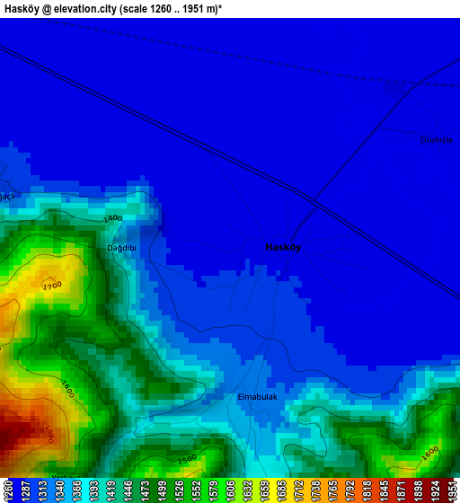
Below is the Elevation map of Hasköy, which displays elevation range with different colors. Scale of the first map is from 1260 to 1951 m (4134 to 6401 ft) with average elevation of 1353 meters (=4439 ft) [note 1]
These maps also provides idea of topography and contour of this city, they are displayed at different zoom levels. More info about maps, scale and edge coordinates you can find below images.
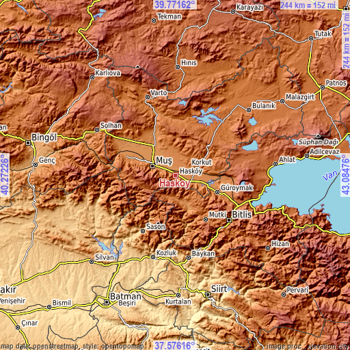
| \ | Map #1 | Topo.Map |
| Scale [m] | 1260..1951 m | × |
| Scale [ft] | 4134..6401 ft | × |
| Average | 1353 m = 4439 ft | × |
| Width | 7.63 km = 4.7 mi | 244.1 km = 151.7 mi |
| Height | 7.63 km = 4.7 mi | 244.1 km = 151.7 mi |
| ↑Max Latitude | 38.716607° | 39.77162° |
| Latitude at center | 38.68231° | 38.68231° |
| ↓Min Latitude | 38.647997° | 37.57616° |
| ← Min Longitude | 41.634565° | 40.27226° |
| Longitude center | 41.67851° | 41.67851° |
| →Max Longitude | 41.722455° | 43.08476° |
Nearby cities:
Cities around Hasköy sort by population:
• Muş elevation 1420 m
17.7 km,  288°
288°
• Güroymak 1304 m
31.6 km,  112°
112°
• Korkut 1295 m
10.8 km,  57°
57°
• Mutki 1567 m
37.2 km,  145°
145°
• Karaköy 1850 m
45.4 km,  0°
0°
• Akçasır 1158 m
44.4 km,  233°
233°
• Geyikpınar 1710 m
42.4 km,  163°
163°
• Yaygın 1280 m
40.2 km,  306°
306°
• Meydan 913 m
37.2 km,  167°
167°
• Kızılağaç 1363 m
33.4 km, 288°
• Mercimekkale 1284 m
31.4 km,  331°
331°
• Kavakbaşı 1360 m
25.3 km, 150°
Multilingual:
 En español:
Hasköy elevación 1279 m.
 En France:
Hasköy élévation 1279 m.


Sources and notes:
- [note 1] Map square and city borders are not equal. Map elevation data is calculated only from area inside that square.
- [src 1] Elevation data from geonames database provided with same terms of usage.
- [src 2] The elevation map of Hasköy is generated using elevation data from NASA's 3 arcsec (90m) resolution SRTM data.
- [src 3] Base (background) map © OpenStreetMap contributors tiles are generated by Geofabrik and OpenTopoMap.
Copyright & License:
This Hasköy Elevation Map is licensed under CC BY-SA. You may reuse any part from this page, if you give a proper credit by linking to this URL:
 More info on terms of use page.