Karakoçan elevation
Karakoçan (Elazığ), Turkey elevation is 1087 meters and Karakoçan elevation in feet is 3566 ft above sea level [src 1]. Karakoçan is a seat of a second-order administrative division (feature code) with elevation that is 364 meters (1194 ft) bigger than average city elevation in Turkey.
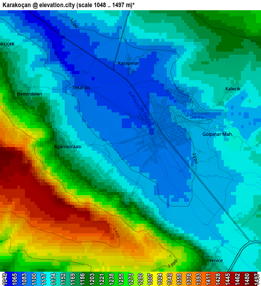
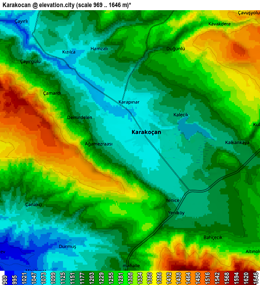
Below is the Elevation map of Karakoçan, which displays elevation range with different colors. Scale of the first map is from 1048 to 1497 m (3438 to 4911 ft) with average elevation of 1179.4 meters (=3869 ft) [note 1]
These maps also provides idea of topography and contour of this city, they are displayed at different zoom levels. More info about maps, scale and edge coordinates you can find below images.
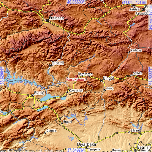
| \ | Map #1 | Map #2 | Topo.Map |
| Scale [m] | 1048..1497 m | 969..1646 m | × |
| Scale [ft] | 3438..4911 ft | 3179..5400 ft | × |
| Average | 1179.4 m = 3869 ft | 1228 m = 4029 ft | × |
| Width | 7.6 km = 4.7 mi | 15.2 km = 9.4 mi | 243.2 km = 151.1 mi |
| Height | 7.6 km = 4.7 mi | 15.2 km = 9.4 mi | 243.2 km = 151.1 mi |
| ↑Max Latitude | 38.985947° | 39.020097° | 40.03693° |
| Latitude at center | 38.95178° | 38.95178° | 38.95178° |
| ↓Min Latitude | 38.917597° | 38.883397° | 37.84976° |
| ← Min Longitude | 39.983115° | 39.939169° | 38.62081° |
| Longitude center | 40.02706° | 40.02706° | 40.02706° |
| →Max Longitude | 40.071005° | 40.114951° | 41.43331° |
Nearby cities:
Cities around Karakoçan sort by population:
• Kovancılar elevation 971 m
29.6 km,  208°
208°
• Palu 889 m
30.4 km,  197°
197°
• Yayladere 1562 m
30.7 km,  6°
6°
• Nazimiye 1521 m
30.6 km,  325°
325°
• Dereova 1480 m
35.9 km,  337°
337°
• Sancak 1584 m
34.8 km,  63°
63°
• Akpazar 879 m
33.2 km,  249°
249°
• Gökdere 1179 m
28 km,  145°
145°
• Çan 1388 m
26.6 km,  34°
34°
• Dallıbahçe 1313 m
23.9 km, 327°
• Darıkent 1176 m
19 km,  273°
273°
• Başyurt 1073 m
13.6 km, 197°
Multilingual:
 En español:
Karakoçan elevación 1087 m.
 En France:
Karakoçan élévation 1087 m.
 Auf Deutsch:
Karakoçan höhe über dem Meeresspiegel ist 1087 m.

Sources and notes:
- [note 1] Map square and city borders are not equal. Map elevation data is calculated only from area inside that square.
- [src 1] Elevation data from geonames database provided with same terms of usage.
- [src 2] The elevation map of Karakoçan is generated using elevation data from NASA's 3 arcsec (90m) resolution SRTM data.
- [src 3] Base (background) map © OpenStreetMap contributors tiles are generated by Geofabrik and OpenTopoMap.
Copyright & License:
This Karakoçan Elevation Map is licensed under CC BY-SA. You may reuse any part from this page, if you give a proper credit by linking to this URL:
 More info on terms of use page.