Karkamış elevation
Karkamış (Gaziantep), Turkey elevation is 357 meters and Karkamış elevation in feet is 1171 ft above sea level [src 1]. Karkamış is a seat of a second-order administrative division (feature code) with elevation that is 366 meters (1201 ft) smaller than average city elevation in Turkey.
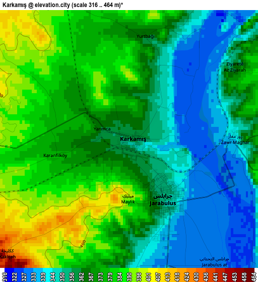
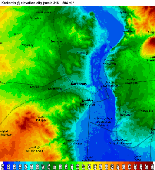
Below is the Elevation map of Karkamış, which displays elevation range with different colors. Scale of the first map is from 316 to 464 m (1037 to 1522 ft) with average elevation of 366.5 meters (=1202 ft) [note 1]
These maps also provides idea of topography and contour of this city, they are displayed at different zoom levels. More info about maps, scale and edge coordinates you can find below images.
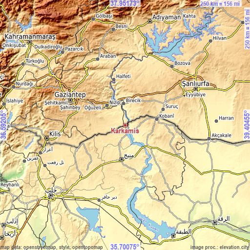
| \ | Map #1 | Map #2 | Topo.Map |
| Scale [m] | 316..464 m | 316..504 m | × |
| Scale [ft] | 1037..1522 ft | 1037..1654 ft | × |
| Average | 366.5 m = 1202 ft | 386.7 m = 1269 ft | × |
| Width | 7.82 km = 4.9 mi | 15.64 km = 9.7 mi | 250.3 km = 155.5 mi |
| Height | 7.82 km = 4.9 mi | 15.64 km = 9.7 mi | 250.3 km = 155.5 mi |
| ↑Max Latitude | 36.869684° | 36.904833° | 37.95173° |
| Latitude at center | 36.83452° | 36.83452° | 36.83452° |
| ↓Min Latitude | 36.799339° | 36.764143° | 35.70075° |
| ← Min Longitude | 37.954355° | 37.910409° | 36.59205° |
| Longitude center | 37.9983° | 37.9983° | 37.9983° |
| →Max Longitude | 38.042245° | 38.086191° | 39.40455° |
Nearby cities:
Cities around Karkamış sort by population:
• Nizip elevation 524 m
26.6 km,  317°
317°
• Suruç 499 m
41.1 km,  67°
67°
• Birecik 351 m
21.3 km,  355°
355°
• Oğuzeli 688 m
45.5 km,  288°
288°
• Uluyatır 568 m
30.6 km,  297°
297°
• Sekili 602 m
33.2 km, 298°
• Küçükkendirci 523 m
31.9 km,  75°
75°
• Mağaralı 453 m
16.4 km,  24°
24°
• İkizce 531 m
20.2 km,  278°
278°
• Doğanpınar 578 m
33.9 km,  271°
271°
• Böğürtlen 715 m
37.6 km,  11°
11°
• Mürşitpınar 516 m
32 km, 76°
Multilingual:
 En español:
Karkamış elevación 357 m.
 En France:
Karkamış élévation 357 m.
 Auf Deutsch:
Karkamış höhe über dem Meeresspiegel ist 357 m.

Sources and notes:
- [note 1] Map square and city borders are not equal. Map elevation data is calculated only from area inside that square.
- [src 1] Elevation data from geonames database provided with same terms of usage.
- [src 2] The elevation map of Karkamış is generated using elevation data from NASA's 3 arcsec (90m) resolution SRTM data.
- [src 3] Base (background) map © OpenStreetMap contributors tiles are generated by Geofabrik and OpenTopoMap.
Copyright & License:
This Karkamış Elevation Map is licensed under CC BY-SA. You may reuse any part from this page, if you give a proper credit by linking to this URL:
 More info on terms of use page.