Kayabağlar elevation
Kayabağlar (Siirt), Turkey elevation is 839 meters and Kayabağlar elevation in feet is 2753 ft above sea level [src 1]. Kayabağlar is a populated place (feature code) with elevation that is 116 meters (381 ft) bigger than average city elevation in Turkey.
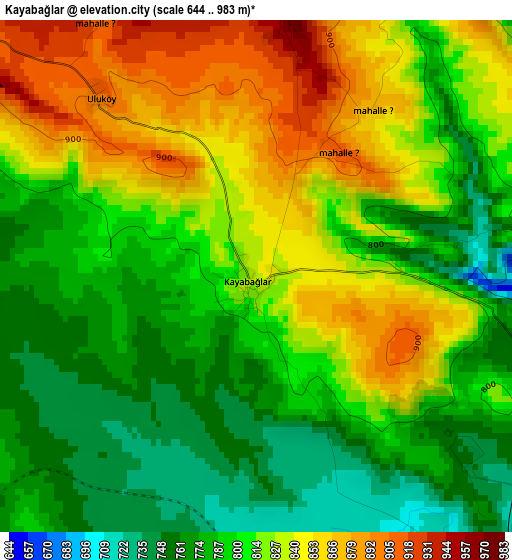
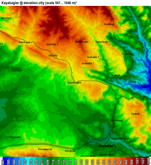
Below is the Elevation map of Kayabağlar, which displays elevation range with different colors. Scale of the first map is from 644 to 983 m (2113 to 3225 ft) with average elevation of 810.5 meters (=2659 ft) [note 1]
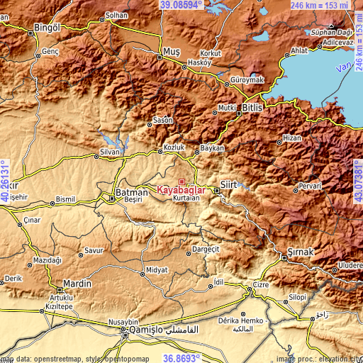
These maps also provides idea of topography and contour of this city, they are displayed at different zoom levels. More info about maps, scale and edge coordinates you can find below images.
| \ | Map #1 | Map #2 | Topo.Map |
| Scale [m] | 644..983 m | 541..1046 m | × |
| Scale [ft] | 2113..3225 ft | 1775..3432 ft | × |
| Average | 810.5 m = 2659 ft | 797.4 m = 2616 ft | × |
| Width | 7.7 km = 4.8 mi | 15.4 km = 9.6 mi | 246.5 km = 153.2 mi |
| Height | 7.7 km = 4.8 mi | 15.4 km = 9.6 mi | 246.5 km = 153.2 mi |
| ↑Max Latitude | 38.020618° | 38.055229° | 39.08594° |
| Latitude at center | 37.98599° | 37.98599° | 37.98599° |
| ↓Min Latitude | 37.951346° | 37.916685° | 36.8693° |
| ← Min Longitude | 41.623615° | 41.579669° | 40.26131° |
| Longitude center | 41.66756° | 41.66756° | 41.66756° |
| →Max Longitude | 41.711505° | 41.755451° | 43.07381° |
Nearby cities:
Cities around Kayabağlar sort by population:
• Siirt elevation 893 m
24.8 km,  104°
104°
• Kurtalan 715 m
6.9 km,  167°
167°
• Kozluk 937 m
28.2 km,  323°
323°
• Baykan 743 m
21.2 km,  25°
25°
• Gözpınar 702 m
18.4 km,  266°
266°
• Civankan 928 m
20.6 km,  116°
116°
• Beşpınar 755 m
17.5 km,  199°
199°
• Taliban 575 m
22.3 km, 268°
• Melefan 834 m
23.3 km,  338°
338°
• Dilektepe 1155 m
17.1 km,  54°
54°
• Bağlıca 913 m
14.9 km,  150°
150°
• Yanarsu 791 m
11.6 km,  299°
299°
Multilingual:
 En español:
Kayabağlar elevación 839 m.
 En France:
Kayabağlar élévation 839 m.
 Auf Deutsch:
Kayabağlar höhe über dem Meeresspiegel ist 839 m.

Sources and notes:
- [note 1] Map square and city borders are not equal. Map elevation data is calculated only from area inside that square.
- [src 1] Elevation data from geonames database provided with same terms of usage.
- [src 2] The elevation map of Kayabağlar is generated using elevation data from NASA's 3 arcsec (90m) resolution SRTM data.
- [src 3] Base (background) map © OpenStreetMap contributors tiles are generated by Geofabrik and OpenTopoMap.
Copyright & License:
This Kayabağlar Elevation Map is licensed under CC BY-SA. You may reuse any part from this page, if you give a proper credit by linking to this URL:
 More info on terms of use page.