Keles elevation
Keles (Bursa), Turkey elevation is 1024 meters and Keles elevation in feet is 3360 ft above sea level [src 1]. Keles is a seat of a second-order administrative division (feature code) with elevation that is 301 meters (988 ft) bigger than average city elevation in Turkey.
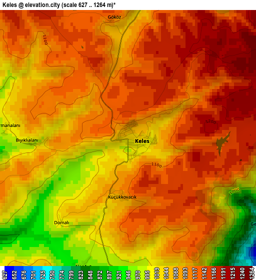
Below is the Elevation map of Keles, which displays elevation range with different colors. Scale of the first map is from 627 to 1264 m (2057 to 4147 ft) with average elevation of 1083.9 meters (=3556 ft) [note 1]
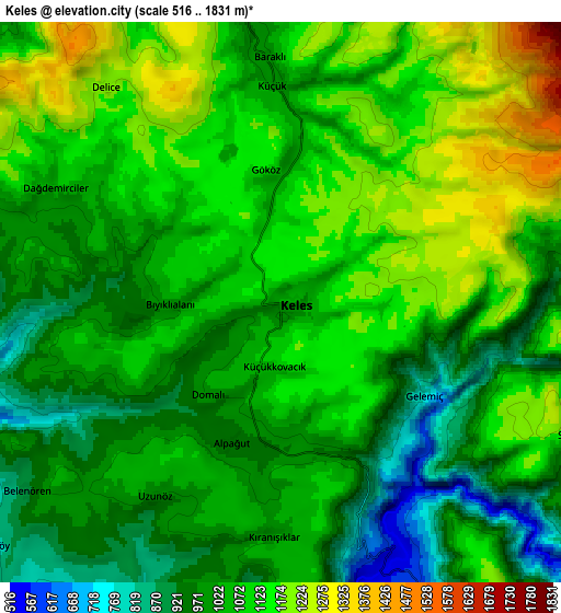
These maps also provides idea of topography and contour of this city, they are displayed at different zoom levels. More info about maps, scale and edge coordinates you can find below images.
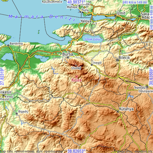
| \ | Map #1 | Map #2 | Topo.Map |
| Scale [m] | 627..1264 m | 516..1831 m | × |
| Scale [ft] | 2057..4147 ft | 1693..6007 ft | × |
| Average | 1083.9 m = 3556 ft | 1063.7 m = 3490 ft | × |
| Width | 7.5 km = 4.7 mi | 14.99 km = 9.3 mi | 239.9 km = 149.1 mi |
| Height | 7.5 km = 4.7 mi | 14.99 km = 9.3 mi | 239.9 km = 149.1 mi |
| ↑Max Latitude | 39.947308° | 39.98099° | 40.98371° |
| Latitude at center | 39.91361° | 39.91361° | 39.91361° |
| ↓Min Latitude | 39.879895° | 39.846164° | 38.82653° |
| ← Min Longitude | 29.185495° | 29.141549° | 27.82319° |
| Longitude center | 29.22944° | 29.22944° | 29.22944° |
| →Max Longitude | 29.273385° | 29.317331° | 30.63569° |
Nearby cities:
Cities around Keles sort by population:
• İnegol elevation 293 m
30.3 km,  52°
52°
• Kestel 122 m
31.7 km,  357°
357°
• Orhaneli 515 m
20.4 km,  266°
266°
• Yenice 769 m
32.3 km,  238°
238°
• Yenice 365 m
25.4 km,  40°
40°
• Kirazlı 929 m
26.1 km,  322°
322°
• Cerrah 327 m
25.5 km, 46°
• Alanyurt 323 m
32.8 km, 48°
• Karıncalı 428 m
32.2 km,  281°
281°
• Büyükorhan 804 m
33.3 km, 241°
• Yıldırım 171 m
32.2 km,  341°
341°
• Harmancık 665 m
27.2 km,  193°
193°
Multilingual:
 En español:
Keles elevación 1024 m.
 En France:
Keles élévation 1024 m.


Sources and notes:
- [note 1] Map square and city borders are not equal. Map elevation data is calculated only from area inside that square.
- [src 1] Elevation data from geonames database provided with same terms of usage.
- [src 2] The elevation map of Keles is generated using elevation data from NASA's 3 arcsec (90m) resolution SRTM data.
- [src 3] Base (background) map © OpenStreetMap contributors tiles are generated by Geofabrik and OpenTopoMap.
Copyright & License:
This Keles Elevation Map is licensed under CC BY-SA. You may reuse any part from this page, if you give a proper credit by linking to this URL:
 More info on terms of use page.