Ortaköy elevation
Ortaköy (Mardin), Turkey elevation is 572 meters and Ortaköy elevation in feet is 1877 ft above sea level [src 1]. Ortaköy is a populated place (feature code) with elevation that is 151 meters (495 ft) smaller than average city elevation in Turkey.
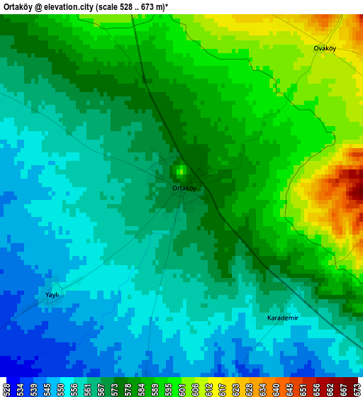
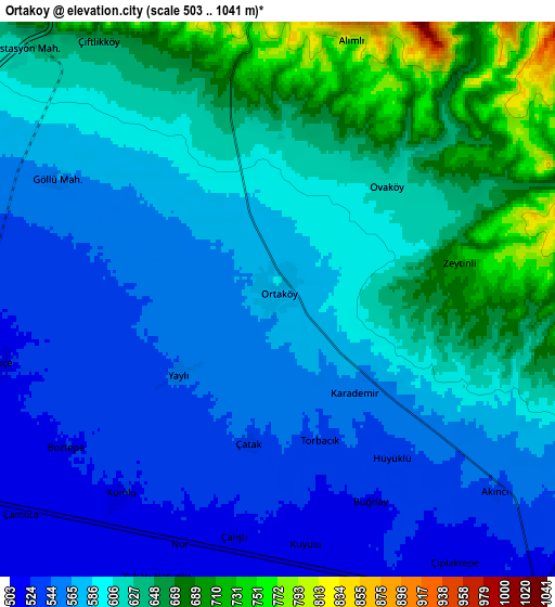
Below is the Elevation map of Ortaköy, which displays elevation range with different colors. Scale of the first map is from 528 to 673 m (1732 to 2208 ft) with average elevation of 573.2 meters (=1881 ft) [note 1]
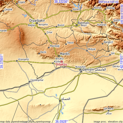
These maps also provides idea of topography and contour of this city, they are displayed at different zoom levels. More info about maps, scale and edge coordinates you can find below images.
| \ | Map #1 | Map #2 | Topo.Map |
| Scale [m] | 528..673 m | 503..1041 m | × |
| Scale [ft] | 1732..2208 ft | 1650..3415 ft | × |
| Average | 573.2 m = 1881 ft | 597.4 m = 1960 ft | × |
| Width | 7.78 km = 4.8 mi | 15.56 km = 9.7 mi | 249 km = 154.7 mi |
| Height | 7.78 km = 4.8 mi | 15.56 km = 9.7 mi | 249 km = 154.7 mi |
| ↑Max Latitude | 37.255876° | 37.290846° | 38.33236° |
| Latitude at center | 37.22089° | 37.22089° | 37.22089° |
| ↓Min Latitude | 37.185888° | 37.150869° | 36.0928° |
| ← Min Longitude | 40.740815° | 40.696869° | 39.37851° |
| Longitude center | 40.78476° | 40.78476° | 40.78476° |
| →Max Longitude | 40.828705° | 40.872651° | 42.19101° |
Nearby cities:
Cities around Ortaköy sort by population:
• Kızıltepe elevation 480 m
18.7 km,  258°
258°
• Mardin 1056 m
10.9 km,  340°
340°
• Yeşilli 790 m
13.4 km,  12°
12°
• Kabala 797 m
14 km, 5°
• Selah 522 m
7.9 km, 257°
• Dara 561 m
15.7 km,  107°
107°
• Yaylı 551 m
3.4 km,  233°
233°
• Kaynakkaya 1099 m
18.6 km,  44°
44°
• Eşme 492 m
14.6 km,  240°
240°
• Kumlu 521 m
7 km,  218°
218°
• Eymirli 513 m
10.3 km, 237°
• Akıncı 526 m
8.2 km,  137°
137°
Multilingual:
 En español:
Ortaköy elevación 572 m.
 En France:
Ortaköy élévation 572 m.
 Auf Deutsch:
Ortaköy höhe über dem Meeresspiegel ist 572 m.
 На русском:
Ортакей, Gyul’kharin высота над уровнем моря 572 м
Sources and notes:
- [note 1] Map square and city borders are not equal. Map elevation data is calculated only from area inside that square.
- [src 1] Elevation data from geonames database provided with same terms of usage.
- [src 2] The elevation map of Ortaköy is generated using elevation data from NASA's 3 arcsec (90m) resolution SRTM data.
- [src 3] Base (background) map © OpenStreetMap contributors tiles are generated by Geofabrik and OpenTopoMap.
Copyright & License:
This Ortaköy Elevation Map is licensed under CC BY-SA. You may reuse any part from this page, if you give a proper credit by linking to this URL:
 More info on terms of use page.