Özdere elevation
Özdere (İzmir), Turkey elevation is 74 meters and Özdere elevation in feet is 243 ft above sea level [src 1]. Özdere is a populated place (feature code) with elevation that is 649 meters (2129 ft) smaller than average city elevation in Turkey.
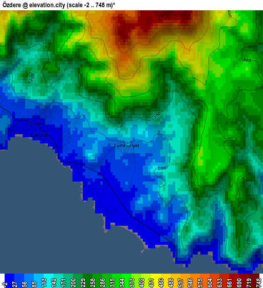
Below is the Elevation map of Özdere, which displays elevation range with different colors. Scale of the first map is from -2 to 748 m (-7 to 2454 ft) with average elevation of 232.1 meters (=761 ft) [note 1]
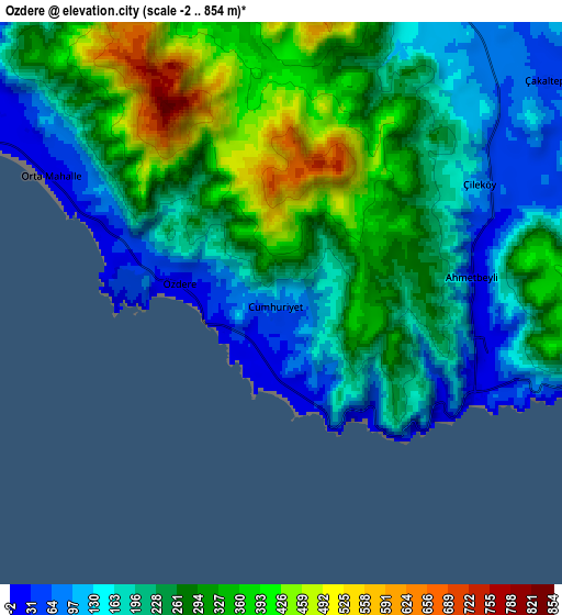
These maps also provides idea of topography and contour of this city, they are displayed at different zoom levels. More info about maps, scale and edge coordinates you can find below images.
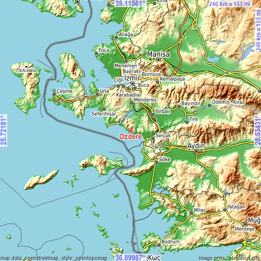
| \ | Map #1 | Map #2 | Topo.Map |
| Scale [m] | -2..748 m | -2..854 m | × |
| Scale [ft] | -7..2454 ft | -7..2802 ft | × |
| Average | 232.1 m = 761 ft | 244.6 m = 802 ft | × |
| Width | 7.7 km = 4.8 mi | 15.4 km = 9.6 mi | 246.4 km = 153.1 mi |
| Height | 7.7 km = 4.8 mi | 15.4 km = 9.6 mi | 246.4 km = 153.1 mi |
| ↑Max Latitude | 38.050724° | 38.085321° | 39.11561° |
| Latitude at center | 38.01611° | 38.01611° | 38.01611° |
| ↓Min Latitude | 37.98148° | 37.946834° | 36.89987° |
| ← Min Longitude | 27.084115° | 27.040169° | 25.72181° |
| Longitude center | 27.12806° | 27.12806° | 27.12806° |
| →Max Longitude | 27.172005° | 27.215951° | 28.53431° |
Nearby cities:
Cities around Özdere sort by population:
• Kuşadası elevation 1 m
20.7 km,  146°
146°
• Torbalı 34 m
25.5 km,  53°
53°
• Selçuk 35 m
22.3 km,  108°
108°
• Menderes 118 m
26 km,  1°
1°
• Seferihisar 34 m
32.4 km,  308°
308°
• Davutlar 62 m
34.5 km,  155°
155°
• Belevi 15 m
28.2 km,  90°
90°
• Boğaziçi 81 m
37.8 km, 86°
• Çırpı 21 m
36.3 km,  62°
62°
• Ortaklar 64 m
35.8 km, 113°
• Gaziemir 144 m
34.2 km, 0°
• Değirmendere 152 m
10.9 km,  6°
6°
Multilingual:
 En español:
Özdere elevación 74 m.
 En France:
Özdere élévation 74 m.


Sources and notes:
- [note 1] Map square and city borders are not equal. Map elevation data is calculated only from area inside that square.
- [src 1] Elevation data from geonames database provided with same terms of usage.
- [src 2] The elevation map of Özdere is generated using elevation data from NASA's 3 arcsec (90m) resolution SRTM data.
- [src 3] Base (background) map © OpenStreetMap contributors tiles are generated by Geofabrik and OpenTopoMap.
Copyright & License:
This Özdere Elevation Map is licensed under CC BY-SA. You may reuse any part from this page, if you give a proper credit by linking to this URL:
 More info on terms of use page.