Şirvan elevation
Şirvan (Siirt), Turkey elevation is 985 meters and Şirvan elevation in feet is 3232 ft above sea level [src 1]. Şirvan is a seat of a second-order administrative division (feature code) with elevation that is 262 meters (860 ft) bigger than average city elevation in Turkey.
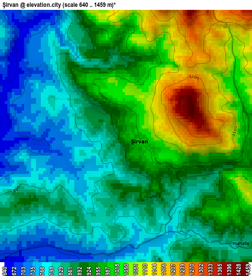
Below is the Elevation map of Şirvan, which displays elevation range with different colors. Scale of the first map is from 640 to 1459 m (2100 to 4787 ft) with average elevation of 908.3 meters (=2980 ft) [note 1]
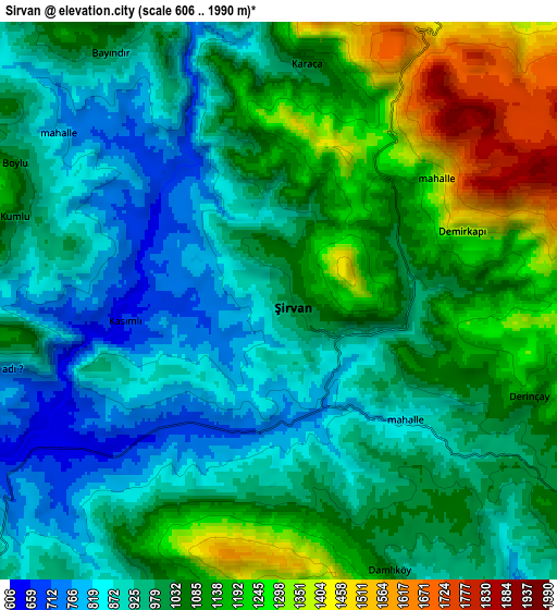
These maps also provides idea of topography and contour of this city, they are displayed at different zoom levels. More info about maps, scale and edge coordinates you can find below images.
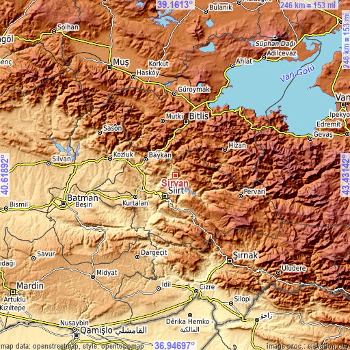
| \ | Map #1 | Map #2 | Topo.Map |
| Scale [m] | 640..1459 m | 606..1990 m | × |
| Scale [ft] | 2100..4787 ft | 1988..6529 ft | × |
| Average | 908.3 m = 2980 ft | 1029.5 m = 3378 ft | × |
| Width | 7.69 km = 4.8 mi | 15.39 km = 9.6 mi | 246.2 km = 153 mi |
| Height | 7.69 km = 4.8 mi | 15.39 km = 9.6 mi | 246.2 km = 153 mi |
| ↑Max Latitude | 38.097102° | 38.131677° | 39.1613° |
| Latitude at center | 38.06251° | 38.06251° | 38.06251° |
| ↓Min Latitude | 38.027902° | 37.993278° | 36.94697° |
| ← Min Longitude | 41.981225° | 41.937279° | 40.61892° |
| Longitude center | 42.02517° | 42.02517° | 42.02517° |
| →Max Longitude | 42.069115° | 42.113061° | 43.43142° |
Nearby cities:
Cities around Şirvan sort by population:
• Siirt elevation 893 m
16.5 km,  206°
206°
• Baykan 743 m
24.4 km,  295°
295°
• Tillo 1199 m
12.7 km,  185°
185°
• Civankan 928 m
21.9 km,  216°
216°
• Palamutlu 1396 m
24.2 km,  140°
140°
• Taşlı 870 m
12.8 km,  131°
131°
• Simek 1570 m
32.2 km,  23°
23°
• Narlıdere 897 m
21.8 km,  327°
327°
• Cevizlik 1483 m
21.6 km,  54°
54°
• Sarıkonak 1215 m
20.9 km,  344°
344°
• Özpınar 1580 m
20.2 km,  108°
108°
• Dilektepe 1155 m
17.4 km,  274°
274°
Multilingual:
 En español:
Şirvan elevación 985 m.
 En France:
Şirvan élévation 985 m.


Sources and notes:
- [note 1] Map square and city borders are not equal. Map elevation data is calculated only from area inside that square.
- [src 1] Elevation data from geonames database provided with same terms of usage.
- [src 2] The elevation map of Şirvan is generated using elevation data from NASA's 3 arcsec (90m) resolution SRTM data.
- [src 3] Base (background) map © OpenStreetMap contributors tiles are generated by Geofabrik and OpenTopoMap.
Copyright & License:
This Şirvan Elevation Map is licensed under CC BY-SA. You may reuse any part from this page, if you give a proper credit by linking to this URL:
 More info on terms of use page.