Kindirip elevation
Kindirip (Mardin), Turkey elevation is 975 meters and Kindirip elevation in feet is 3199 ft above sea level [src 1]. Kindirip is a populated place (feature code) with elevation that is 252 meters (827 ft) bigger than average city elevation in Turkey.
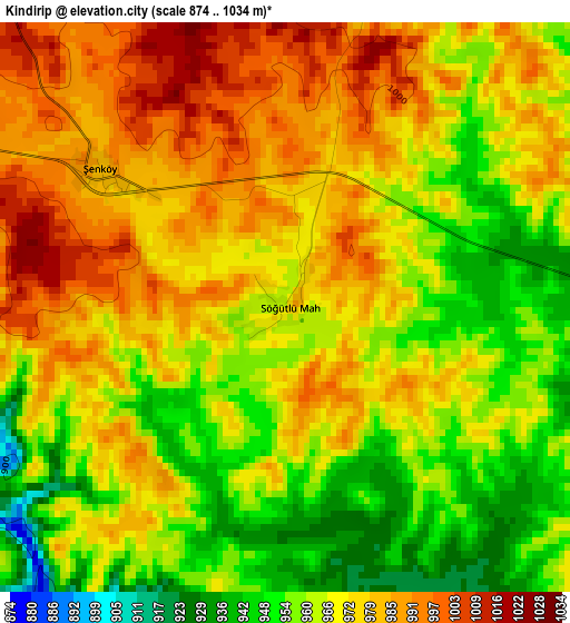
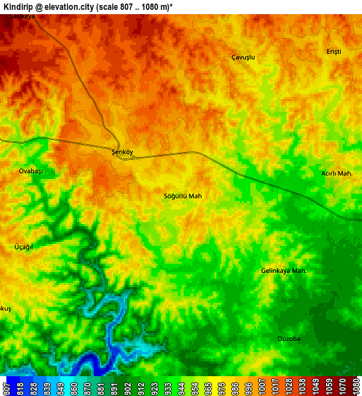
Below is the Elevation map of Kindirip, which displays elevation range with different colors. Scale of the first map is from 874 to 1034 m (2867 to 3392 ft) with average elevation of 969.9 meters (=3182 ft) [note 1]
These maps also provides idea of topography and contour of this city, they are displayed at different zoom levels. More info about maps, scale and edge coordinates you can find below images.
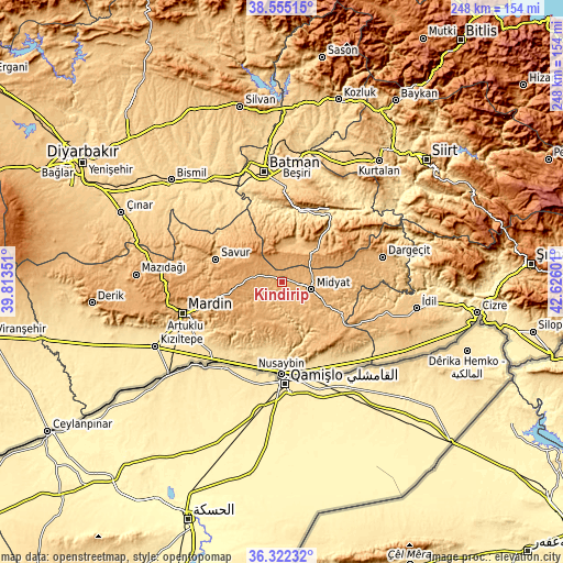
| \ | Map #1 | Map #2 | Topo.Map |
| Scale [m] | 874..1034 m | 807..1080 m | × |
| Scale [ft] | 2867..3392 ft | 2648..3543 ft | × |
| Average | 969.9 m = 3182 ft | 963.2 m = 3160 ft | × |
| Width | 7.76 km = 4.8 mi | 15.52 km = 9.6 mi | 248.3 km = 154.3 mi |
| Height | 7.76 km = 4.8 mi | 15.52 km = 9.6 mi | 248.3 km = 154.3 mi |
| ↑Max Latitude | 37.481941° | 37.516805° | 38.55515° |
| Latitude at center | 37.44706° | 37.44706° | 37.44706° |
| ↓Min Latitude | 37.412163° | 37.37725° | 36.32232° |
| ← Min Longitude | 41.175815° | 41.131869° | 39.81351° |
| Longitude center | 41.21976° | 41.21976° | 41.21976° |
| →Max Longitude | 41.263705° | 41.307651° | 42.62601° |
Nearby cities:
Cities around Kindirip sort by population:
• Midyat elevation 949 m
11 km,  106°
106°
• Ebish 988 m
3.3 km,  303°
303°
• Çavuşlu 975 m
6.6 km,  22°
22°
• Acırlı 978 m
6.7 km,  81°
81°
• Gelinkaya 949 m
5.6 km,  127°
127°
• Yolbaşı 924 m
10.9 km, 127°
• Kayapınar 1154 m
13.3 km,  337°
337°
• Yolağzı 1043 m
14.7 km,  53°
53°
• Kutlubey 954 m
16 km,  193°
193°
• Kayalıpınar 788 m
13.1 km,  176°
176°
• Çalpınar 813 m
9.6 km,  198°
198°
• Seri 967 m
12 km,  143°
143°
Multilingual:
 En español:
Kindirip elevación 975 m.
 En France:
Kindirip élévation 975 m.
 Auf Deutsch:
Kindirip höhe über dem Meeresspiegel ist 975 m.

Sources and notes:
- [note 1] Map square and city borders are not equal. Map elevation data is calculated only from area inside that square.
- [src 1] Elevation data from geonames database provided with same terms of usage.
- [src 2] The elevation map of Kindirip is generated using elevation data from NASA's 3 arcsec (90m) resolution SRTM data.
- [src 3] Base (background) map © OpenStreetMap contributors tiles are generated by Geofabrik and OpenTopoMap.
Copyright & License:
This Kindirip Elevation Map is licensed under CC BY-SA. You may reuse any part from this page, if you give a proper credit by linking to this URL:
 More info on terms of use page.