Solhan elevation
Solhan (Bingöl), Turkey elevation is 1356 meters and Solhan elevation in feet is 4449 ft above sea level [src 1]. Solhan is a seat of a second-order administrative division (feature code) with elevation that is 633 meters (2077 ft) bigger than average city elevation in Turkey.
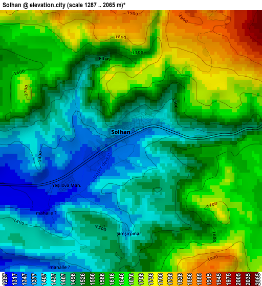
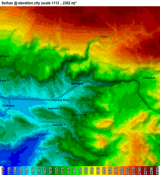
Below is the Elevation map of Solhan, which displays elevation range with different colors. Scale of the first map is from 1287 to 2065 m (4222 to 6775 ft) with average elevation of 1567.2 meters (=5142 ft) [note 1]
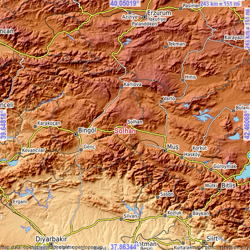
These maps also provides idea of topography and contour of this city, they are displayed at different zoom levels. More info about maps, scale and edge coordinates you can find below images.
| \ | Map #1 | Map #2 | Topo.Map |
| Scale [m] | 1287..2065 m | 1113..2302 m | × |
| Scale [ft] | 4222..6775 ft | 3652..7552 ft | × |
| Average | 1567.2 m = 5142 ft | 1697.4 m = 5569 ft | × |
| Width | 7.6 km = 4.7 mi | 15.2 km = 9.4 mi | 243.1 km = 151.1 mi |
| Height | 7.6 km = 4.7 mi | 15.2 km = 9.4 mi | 243.1 km = 151.1 mi |
| ↑Max Latitude | 38.99941° | 39.033554° | 40.05019° |
| Latitude at center | 38.96525° | 38.96525° | 38.96525° |
| ↓Min Latitude | 38.931073° | 38.89688° | 37.86344° |
| ← Min Longitude | 41.010485° | 40.966539° | 39.64818° |
| Longitude center | 41.05443° | 41.05443° | 41.05443° |
| →Max Longitude | 41.098375° | 41.142321° | 42.46068° |
Nearby cities:
Cities around Solhan sort by population:
• Muş elevation 1420 m
45.4 km,  124°
124°
• Varto 1523 m
41.6 km,  56°
56°
• Karlıova 1835 m
36.4 km,  353°
353°
• Mercimekkale 1284 m
39 km,  95°
95°
• Çaylar 1645 m
39 km,  30°
30°
• Söğütlü 1204 m
38 km,  241°
241°
• Ilıcalar 1168 m
32.9 km,  272°
272°
• Kızılağaç 1363 m
30.5 km,  132°
132°
• Yenisu 1697 m
28.3 km,  213°
213°
• Göynük 1796 m
24.8 km,  321°
321°
• Yaygın 1280 m
23 km,  109°
109°
• Yenibaşak 1590 m
18.7 km,  196°
196°
Multilingual:
 En español:
Solhan elevación 1356 m.
 En France:
Solhan élévation 1356 m.


Sources and notes:
- [note 1] Map square and city borders are not equal. Map elevation data is calculated only from area inside that square.
- [src 1] Elevation data from geonames database provided with same terms of usage.
- [src 2] The elevation map of Solhan is generated using elevation data from NASA's 3 arcsec (90m) resolution SRTM data.
- [src 3] Base (background) map © OpenStreetMap contributors tiles are generated by Geofabrik and OpenTopoMap.
Copyright & License:
This Solhan Elevation Map is licensed under CC BY-SA. You may reuse any part from this page, if you give a proper credit by linking to this URL:
 More info on terms of use page.