Pavlu Cebel elevation
Pavlu Cebel (Isparta), Turkey elevation is 1086 meters and Pavlu Cebel elevation in feet is 3563 ft above sea level [src 1]. Pavlu Cebel is a seat of a second-order administrative division (feature code) with elevation that is 363 meters (1191 ft) bigger than average city elevation in Turkey.
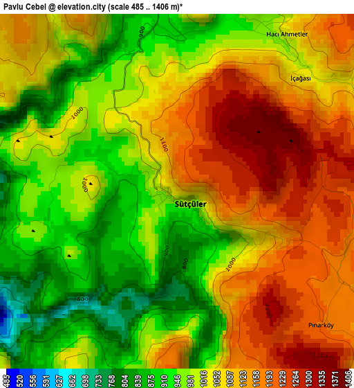
Below is the Elevation map of Pavlu Cebel, which displays elevation range with different colors. Scale of the first map is from 485 to 1406 m (1591 to 4613 ft) with average elevation of 1042 meters (=3419 ft) [note 1]
These maps also provides idea of topography and contour of this city, they are displayed at different zoom levels. More info about maps, scale and edge coordinates you can find below images.
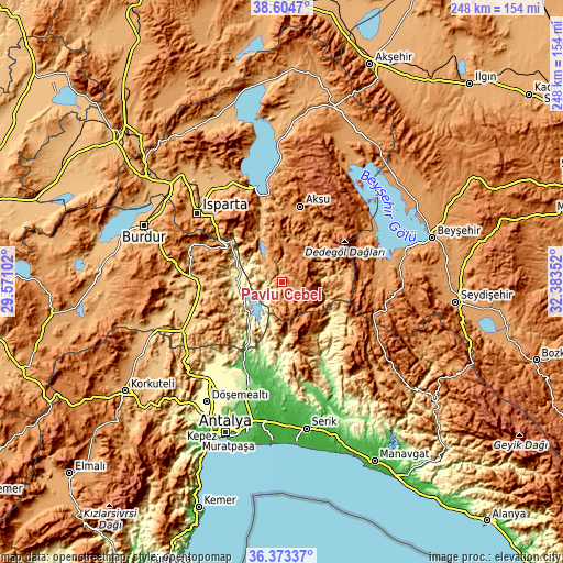
| \ | Map #1 | Topo.Map |
| Scale [m] | 485..1406 m | × |
| Scale [ft] | 1591..4613 ft | × |
| Average | 1042 m = 3419 ft | × |
| Width | 7.75 km = 4.8 mi | 248.1 km = 154.2 mi |
| Height | 7.75 km = 4.8 mi | 248.1 km = 154.2 mi |
| ↑Max Latitude | 37.532227° | 38.6047° |
| Latitude at center | 37.49737° | 37.49737° |
| ↓Min Latitude | 37.462496° | 36.37337° |
| ← Min Longitude | 30.933325° | 29.57102° |
| Longitude center | 30.97727° | 30.97727° |
| →Max Longitude | 31.021215° | 32.38352° |
Nearby cities:
Cities around Pavlu Cebel sort by population:
• Isparta elevation 1069 m
47.8 km,  308°
308°
• Bucak 819 m
34 km,  262°
262°
• Eğirdir 925 m
43.4 km,  345°
345°
• Yenişarbademli 1185 m
43 km,  57°
57°
• Ağlasun 1133 m
42.6 km,  293°
293°
• Aksu 1229 m
34.5 km,  13°
13°
• Anamas 2130 m
33.8 km,  332°
332°
• Kocaaliler 632 m
29 km,  226°
226°
• Çeltikçi 855 m
44 km,  274°
274°
• Gebiz 58 m
43.9 km,  184°
184°
• Beşkonak 141 m
43.9 km,  153°
153°
• Kasımlar 1022 m
19.3 km,  79°
79°
Multilingual:
 En español:
Pavlu Cebel elevación 1086 m.
 En France:
Pavlu Cebel élévation 1086 m.
 Auf Deutsch:
Pavlu Cebel höhe über dem Meeresspiegel ist 1086 m.

Sources and notes:
- [note 1] Map square and city borders are not equal. Map elevation data is calculated only from area inside that square.
- [src 1] Elevation data from geonames database provided with same terms of usage.
- [src 2] The elevation map of Pavlu Cebel is generated using elevation data from NASA's 3 arcsec (90m) resolution SRTM data.
- [src 3] Base (background) map © OpenStreetMap contributors tiles are generated by Geofabrik and OpenTopoMap.
Copyright & License:
This Pavlu Cebel Elevation Map is licensed under CC BY-SA. You may reuse any part from this page, if you give a proper credit by linking to this URL:
 More info on terms of use page.