Tahtaköprü elevation
Tahtaköprü (Bursa), Turkey elevation is 578 meters and Tahtaköprü elevation in feet is 1896 ft above sea level [src 1]. Tahtaköprü is a seat of a third-order administrative division (feature code) with elevation that is 145 meters (476 ft) smaller than average city elevation in Turkey.
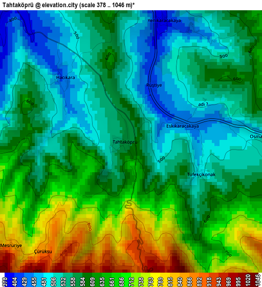
Below is the Elevation map of Tahtaköprü, which displays elevation range with different colors. Scale of the first map is from 378 to 1046 m (1240 to 3432 ft) with average elevation of 602.1 meters (=1975 ft) [note 1]
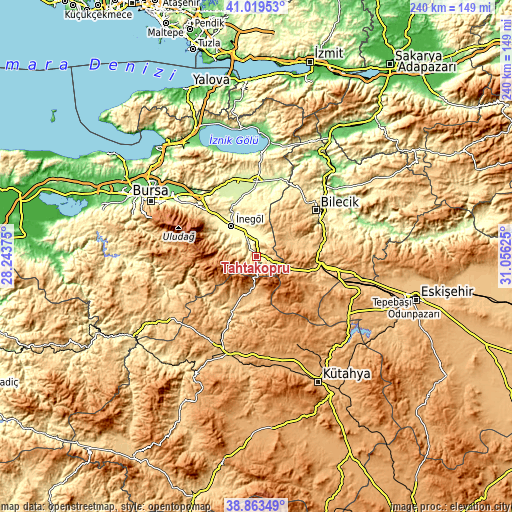
These maps also provides idea of topography and contour of this city, they are displayed at different zoom levels. More info about maps, scale and edge coordinates you can find below images.
| \ | Map #1 | Topo.Map |
| Scale [m] | 378..1046 m | × |
| Scale [ft] | 1240..3432 ft | × |
| Average | 602.1 m = 1975 ft | × |
| Width | 7.49 km = 4.7 mi | 239.7 km = 148.9 mi |
| Height | 7.49 km = 4.7 mi | 239.7 km = 148.9 mi |
| ↑Max Latitude | 39.98368° | 41.01953° |
| Latitude at center | 39.95° | 39.95° |
| ↓Min Latitude | 39.916303° | 38.86349° |
| ← Min Longitude | 29.606055° | 28.24375° |
| Longitude center | 29.65° | 29.65° |
| →Max Longitude | 29.693945° | 31.05625° |
Nearby cities:
Cities around Tahtaköprü sort by population:
• İnegol elevation 293 m
18.4 km,  320°
320°
• Bozüyük 752 m
33.3 km,  98°
98°
• Yenişehir 228 m
35 km,  0°
0°
• Pazaryeri 808 m
22.2 km,  77°
77°
• Domaniç 888 m
16.8 km,  191°
191°
• Yenice 365 m
24.7 km,  308°
308°
• Kurşunlu 331 m
9.7 km, 4°
• Cerrah 327 m
21.9 km, 307°
• Dodurga 1098 m
28.3 km,  126°
126°
• Alanyurt 323 m
20.9 km,  327°
327°
• Hamzabey 286 m
23.2 km, 333°
• Küplü 332 m
34.1 km,  61°
61°
Multilingual:
 En español:
Tahtaköprü elevación 578 m.
 En France:
Tahtaköprü élévation 578 m.
 Auf Deutsch:
Tahtaköprü höhe über dem Meeresspiegel ist 578 m.

Sources and notes:
- [note 1] Map square and city borders are not equal. Map elevation data is calculated only from area inside that square.
- [src 1] Elevation data from geonames database provided with same terms of usage.
- [src 2] The elevation map of Tahtaköprü is generated using elevation data from NASA's 3 arcsec (90m) resolution SRTM data.
- [src 3] Base (background) map © OpenStreetMap contributors tiles are generated by Geofabrik and OpenTopoMap.
Copyright & License:
This Tahtaköprü Elevation Map is licensed under CC BY-SA. You may reuse any part from this page, if you give a proper credit by linking to this URL:
 More info on terms of use page.