Ulubey elevation
Ulubey (Uşak), Turkey elevation is 743 meters and Ulubey elevation in feet is 2438 ft above sea level [src 1]. Ulubey is a seat of a second-order administrative division (feature code) with elevation that is 20 meters (66 ft) bigger than average city elevation in Turkey.
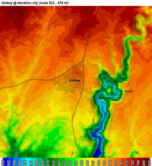
Below is the Elevation map of Ulubey, which displays elevation range with different colors. Scale of the first map is from 532 to 816 m (1745 to 2677 ft) with average elevation of 725.2 meters (=2379 ft) [note 1]
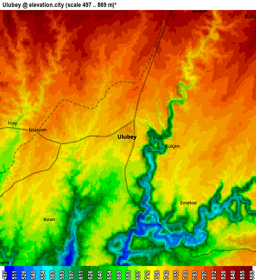
These maps also provides idea of topography and contour of this city, they are displayed at different zoom levels. More info about maps, scale and edge coordinates you can find below images.
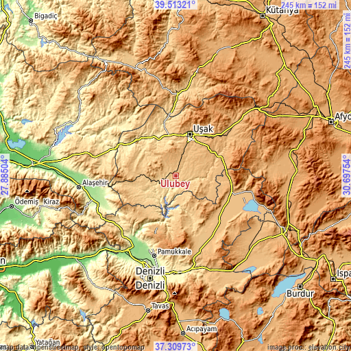
| \ | Map #1 | Map #2 | Topo.Map |
| Scale [m] | 532..816 m | 497..869 m | × |
| Scale [ft] | 1745..2677 ft | 1631..2851 ft | × |
| Average | 725.2 m = 2379 ft | 733.5 m = 2406 ft | × |
| Width | 7.66 km = 4.8 mi | 15.31 km = 9.5 mi | 245 km = 152.2 mi |
| Height | 7.66 km = 4.8 mi | 15.31 km = 9.5 mi | 245 km = 152.2 mi |
| ↑Max Latitude | 38.454292° | 38.488698° | 39.51321° |
| Latitude at center | 38.41987° | 38.41987° | 38.41987° |
| ↓Min Latitude | 38.385432° | 38.350977° | 37.30973° |
| ← Min Longitude | 29.247345° | 29.203399° | 27.88504° |
| Longitude center | 29.29129° | 29.29129° | 29.29129° |
| →Max Longitude | 29.335235° | 29.379181° | 30.69754° |
Nearby cities:
Cities around Ulubey sort by population:
• Uşak elevation 910 m
29.9 km,  19°
19°
• Eşme 826 m
28.2 km,  265°
265°
• Sivaslı 942 m
35.3 km,  75°
75°
• Karahallı 940 m
23.6 km,  117°
117°
• Bekilli 835 m
23.8 km,  151°
151°
• Bölme 896 m
23.5 km, 17°
• Akkent 851 m
30.7 km,  165°
165°
• İlyaslı 768 m
21.9 km,  338°
338°
• Selçikler 905 m
32.8 km,  74°
74°
• Güllü 646 m
23.2 km,  224°
224°
• Güney 752 m
35.4 km,  213°
213°
• Güre 606 m
27.9 km, 337°
Multilingual:
 En español:
Ulubey elevación 743 m.
 En France:
Ulubey élévation 743 m.


Sources and notes:
- [note 1] Map square and city borders are not equal. Map elevation data is calculated only from area inside that square.
- [src 1] Elevation data from geonames database provided with same terms of usage.
- [src 2] The elevation map of Ulubey is generated using elevation data from NASA's 3 arcsec (90m) resolution SRTM data.
- [src 3] Base (background) map © OpenStreetMap contributors tiles are generated by Geofabrik and OpenTopoMap.
Copyright & License:
This Ulubey Elevation Map is licensed under CC BY-SA. You may reuse any part from this page, if you give a proper credit by linking to this URL:
 More info on terms of use page.