Yeşilalan elevation
Yeşilalan (Mardin), Turkey elevation is 972 meters and Yeşilalan elevation in feet is 3189 ft above sea level [src 1]. Yeşilalan is a populated place (feature code) with elevation that is 249 meters (817 ft) bigger than average city elevation in Turkey.
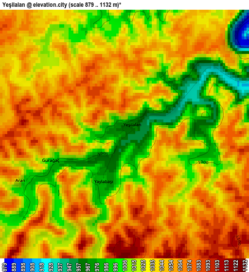
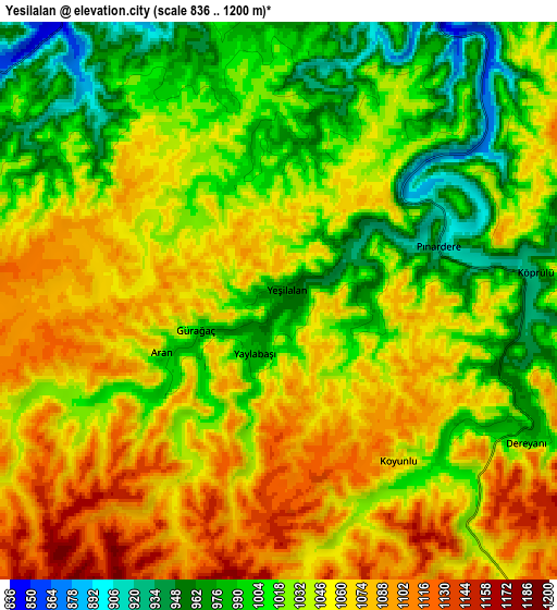
Below is the Elevation map of Yeşilalan, which displays elevation range with different colors. Scale of the first map is from 879 to 1132 m (2884 to 3714 ft) with average elevation of 1036.3 meters (=3400 ft) [note 1]
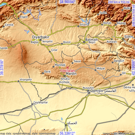
These maps also provides idea of topography and contour of this city, they are displayed at different zoom levels. More info about maps, scale and edge coordinates you can find below images.
| \ | Map #1 | Map #2 | Topo.Map |
| Scale [m] | 879..1132 m | 836..1200 m | × |
| Scale [ft] | 2884..3714 ft | 2743..3937 ft | × |
| Average | 1036.3 m = 3400 ft | 1037.2 m = 3403 ft | × |
| Width | 7.76 km = 4.8 mi | 15.51 km = 9.6 mi | 248.2 km = 154.2 mi |
| Height | 7.76 km = 4.8 mi | 15.51 km = 9.6 mi | 248.2 km = 154.2 mi |
| ↑Max Latitude | 37.495534° | 37.530392° | 38.56854° |
| Latitude at center | 37.46066° | 37.46066° | 37.46066° |
| ↓Min Latitude | 37.425769° | 37.390862° | 36.33612° |
| ← Min Longitude | 40.740465° | 40.696519° | 39.37816° |
| Longitude center | 40.78441° | 40.78441° | 40.78441° |
| →Max Longitude | 40.828355° | 40.872301° | 42.19066° |
Nearby cities:
Cities around Yeşilalan sort by population:
• Yeşilli elevation 790 m
13.9 km,  167°
167°
• Kabala 797 m
12.8 km, 173°
• Savur 961 m
11.8 km,  45°
45°
• Ömerli 1093 m
16.5 km,  114°
114°
• Avine 854 m
13.4 km,  339°
339°
• Pınardere 926 m
4.6 km,  73°
73°
• Başkavak 803 m
14.7 km,  38°
38°
• Çınaraltı 1073 m
10.7 km,  141°
141°
• Bağlıca 882 m
11.4 km,  310°
310°
• Aran 1023 m
3.6 km,  246°
246°
• Reshidi 1133 m
16.6 km,  76°
76°
• Dereyanı 977 m
7.7 km,  118°
118°
Multilingual:
 En español:
Yeşilalan elevación 972 m.
 En France:
Yeşilalan élévation 972 m.
 Auf Deutsch:
Yeşilalan höhe über dem Meeresspiegel ist 972 m.

Sources and notes:
- [note 1] Map square and city borders are not equal. Map elevation data is calculated only from area inside that square.
- [src 1] Elevation data from geonames database provided with same terms of usage.
- [src 2] The elevation map of Yeşilalan is generated using elevation data from NASA's 3 arcsec (90m) resolution SRTM data.
- [src 3] Base (background) map © OpenStreetMap contributors tiles are generated by Geofabrik and OpenTopoMap.
Copyright & License:
This Yeşilalan Elevation Map is licensed under CC BY-SA. You may reuse any part from this page, if you give a proper credit by linking to this URL:
 More info on terms of use page.