Bir el Hafey elevation
Bir el Hafey (Sīdī Bū Zayd, Bir El Hafey), Tunisia elevation is 438 meters and Bir el Hafey elevation in feet is 1437 ft above sea level [src 1]. Bir el Hafey is a populated place (feature code) with elevation that is 289 meters (948 ft) bigger than average city elevation in Tunisia.
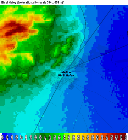
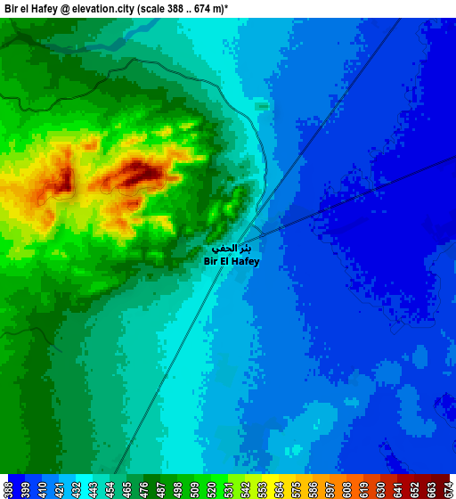
Below is the Elevation map of Bir el Hafey, which displays elevation range with different colors. Scale of the first map is from 394 to 674 m (1293 to 2211 ft) with average elevation of 454.7 meters (=1492 ft) [note 1]
These maps also provides idea of topography and contour of this city, they are displayed at different zoom levels. More info about maps, scale and edge coordinates you can find below images.
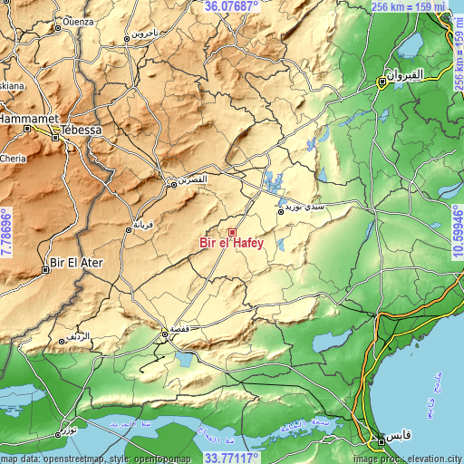
| \ | Map #1 | Map #2 | Topo.Map |
| Scale [m] | 394..674 m | 388..674 m | × |
| Scale [ft] | 1293..2211 ft | 1273..2211 ft | × |
| Average | 454.7 m = 1492 ft | 448.9 m = 1473 ft | × |
| Width | 8.01 km = 5 mi | 16.02 km = 10 mi | 256.4 km = 159.3 mi |
| Height | 8.01 km = 5 mi | 16.02 km = 10 mi | 256.4 km = 159.3 mi |
| ↑Max Latitude | 34.96814° | 35.004144° | 36.07687° |
| Latitude at center | 34.93212° | 34.93212° | 34.93212° |
| ↓Min Latitude | 34.896084° | 34.860033° | 33.77117° |
| ← Min Longitude | 9.149265° | 9.105319° | 7.78696° |
| Longitude center | 9.19321° | 9.19321° | 9.19321° |
| →Max Longitude | 9.237155° | 9.281101° | 10.59946° |
Nearby cities:
Cities around Bir el Hafey sort by population:
• Kasserine elevation 674 m
41.7 km,  308°
308°
• Gafsa 295 m
67.7 km,  213°
213°
• Sidi Bouzid 332 m
29.1 km,  66°
66°
• Thala 962 m
85.6 km,  326°
326°
• As Sanad 600 m
52.6 km,  172°
172°
• Haffouz 284 m
89.4 km,  29°
29°
• Er Regueb 195 m
54.7 km,  98°
98°
• Sbiba 637 m
68.8 km,  350°
350°
• Jilma 364 m
43.3 km, 28°
• Mezzouna 155 m
71.2 km,  123°
123°
• Bir Ali Ben Khalifa 172 m
84.9 km, 104°
• Rohia 627 m
81 km, 350°
Multilingual:
 En español:
Bir el Hafey elevación 438 m.
 En France:
Bir el Hafey élévation 438 m.
 Auf Deutsch:
Bir el Hafey höhe über dem Meeresspiegel ist 438 m.

Sources and notes:
- [note 1] Map square and city borders are not equal. Map elevation data is calculated only from area inside that square.
- [src 1] Elevation data from geonames database provided with same terms of usage.
- [src 2] The elevation map of Bir el Hafey is generated using elevation data from NASA's 3 arcsec (90m) resolution SRTM data.
- [src 3] Base (background) map © OpenStreetMap contributors tiles are generated by Geofabrik and OpenTopoMap.
Copyright & License:
This Bir el Hafey Elevation Map is licensed under CC BY-SA. You may reuse any part from this page, if you give a proper credit by linking to this URL:
 More info on terms of use page.