Annau elevation
Annau (Ahal), Turkmenistan elevation is 247 meters and Annau elevation in feet is 810 ft above sea level [src 1]. Annau is a seat of a first-order administrative division (feature code) with elevation that is 51 meters (167 ft) bigger than average city elevation in Turkmenistan.
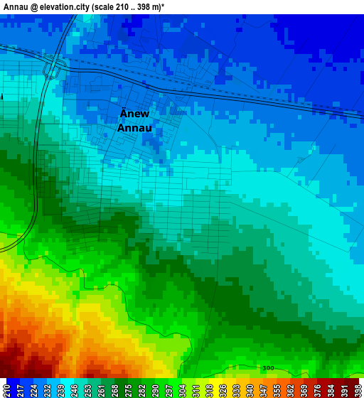
Below is the Elevation map of Annau, which displays elevation range with different colors. Scale of the first map is from 210 to 398 m (689 to 1306 ft) with average elevation of 259.3 meters (=851 ft) [note 1]
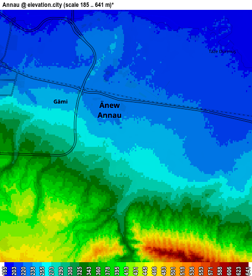
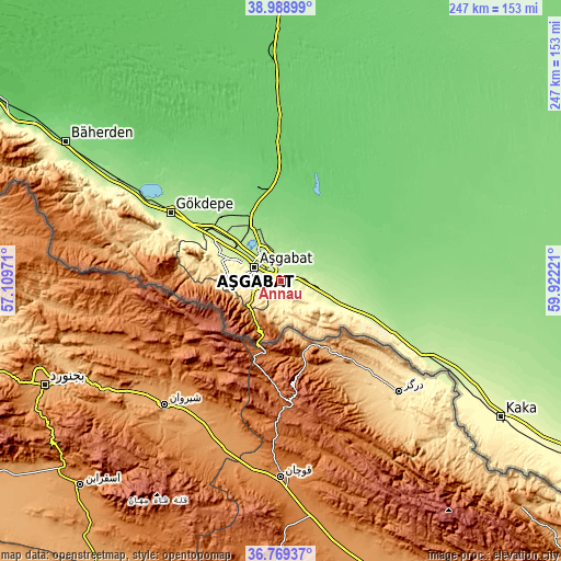
These maps also provides idea of topography and contour of this city, they are displayed at different zoom levels. More info about maps, scale and edge coordinates you can find below images.
| \ | Map #1 | Map #2 | Topo.Map |
| Scale [m] | 210..398 m | 185..641 m | × |
| Scale [ft] | 689..1306 ft | 607..2103 ft | × |
| Average | 259.3 m = 851 ft | 286.8 m = 941 ft | × |
| Width | 7.71 km = 4.8 mi | 15.43 km = 9.6 mi | 246.8 km = 153.4 mi |
| Height | 7.71 km = 4.8 mi | 15.43 km = 9.6 mi | 246.8 km = 153.4 mi |
| ↑Max Latitude | 37.922214° | 37.956872° | 38.98899° |
| Latitude at center | 37.88754° | 37.88754° | 37.88754° |
| ↓Min Latitude | 37.852849° | 37.818143° | 36.76937° |
| ← Min Longitude | 58.472015° | 58.428069° | 57.10971° |
| Longitude center | 58.51596° | 58.51596° | 58.51596° |
| →Max Longitude | 58.559905° | 58.603851° | 59.92221° |
Nearby cities:
Cities around Annau sort by population:
• Ashgabat elevation 219 m
13.5 km,  300°
300°
• Mary 223 m
293.2 km,  96°
96°
• Bayramaly 239 m
322.4 km, 95°
• Tejen 190 m
183.9 km,  107°
107°
• Abadan 228 m
33.5 km, 303°
• Baharly 160 m
112.7 km, 302°
• Bereket 34 m
301.3 km, 300°
• Kaka 290 m
113.8 km,  121°
121°
• Murgab 228 m
307.1 km, 98°
• Serdar 103 m
229.6 km, 301°
• Arçabil 649 m
37.5 km,  274°
274°
• Magtymguly 314 m
204.7 km,  287°
287°
Multilingual:
 En español:
Annau elevación 247 m.
 En France:
Annau élévation 247 m.


Sources and notes:
- [note 1] Map square and city borders are not equal. Map elevation data is calculated only from area inside that square.
- [src 1] Elevation data from geonames database provided with same terms of usage.
- [src 2] The elevation map of Annau is generated using elevation data from NASA's 3 arcsec (90m) resolution SRTM data.
- [src 3] Base (background) map © OpenStreetMap contributors tiles are generated by Geofabrik and OpenTopoMap.
Copyright & License:
This Annau Elevation Map is licensed under CC BY-SA. You may reuse any part from this page, if you give a proper credit by linking to this URL:
 More info on terms of use page.