Bereket elevation
Bereket (Balkan), Turkmenistan elevation is 34 meters and Bereket elevation in feet is 112 ft above sea level [src 1]. Bereket is a populated place (feature code) with elevation that is 162 meters (531 ft) smaller than average city elevation in Turkmenistan.
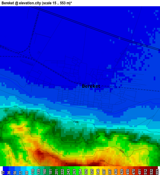
Below is the Elevation map of Bereket, which displays elevation range with different colors. Scale of the first map is from 15 to 553 m (49 to 1814 ft) with average elevation of 105.3 meters (=345 ft) [note 1]
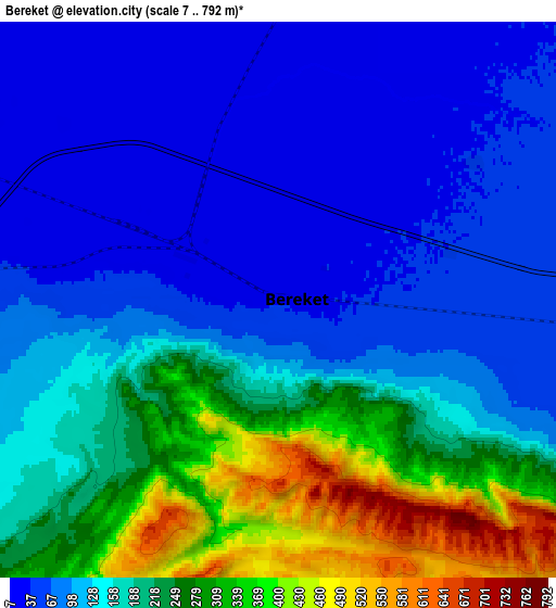
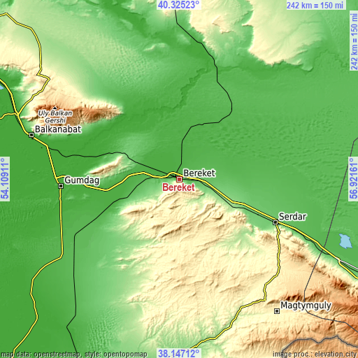
These maps also provides idea of topography and contour of this city, they are displayed at different zoom levels. More info about maps, scale and edge coordinates you can find below images.
| \ | Map #1 | Map #2 | Topo.Map |
| Scale [m] | 15..553 m | 7..792 m | × |
| Scale [ft] | 49..1814 ft | 23..2598 ft | × |
| Average | 105.3 m = 345 ft | 160.6 m = 527 ft | × |
| Width | 7.57 km = 4.7 mi | 15.14 km = 9.4 mi | 242.2 km = 150.5 mi |
| Height | 7.57 km = 4.7 mi | 15.14 km = 9.4 mi | 242.2 km = 150.5 mi |
| ↑Max Latitude | 39.278655° | 39.312664° | 40.32523° |
| Latitude at center | 39.24463° | 39.24463° | 39.24463° |
| ↓Min Latitude | 39.210588° | 39.17653° | 38.14712° |
| ← Min Longitude | 55.471415° | 55.427469° | 54.10911° |
| Longitude center | 55.51536° | 55.51536° | 55.51536° |
| →Max Longitude | 55.559305° | 55.603251° | 56.92161° |
Nearby cities:
Cities around Bereket sort by population:
• Ashgabat elevation 219 m
287.8 km,  120°
120°
• Balkanabat 11 m
103 km,  286°
286°
• Türkmenbaşy 5 m
235.7 km, 291°
• Abadan 228 m
267.9 km, 119°
• Annau 247 m
301.3 km, 120°
• Gumdag 5 m
79.8 km,  266°
266°
• Baharly 160 m
188.7 km, 118°
• Serdar 103 m
72.1 km,  114°
114°
• Arçabil 649 m
268.2 km, 123°
• Magtymguly 314 m
111.6 km,  143°
143°
Multilingual:
 En español:
Bereket elevación 34 m.
 En France:
Bereket élévation 34 m.


Sources and notes:
- [note 1] Map square and city borders are not equal. Map elevation data is calculated only from area inside that square.
- [src 1] Elevation data from geonames database provided with same terms of usage.
- [src 2] The elevation map of Bereket is generated using elevation data from NASA's 3 arcsec (90m) resolution SRTM data.
- [src 3] Base (background) map © OpenStreetMap contributors tiles are generated by Geofabrik and OpenTopoMap.
Copyright & License:
This Bereket Elevation Map is licensed under CC BY-SA. You may reuse any part from this page, if you give a proper credit by linking to this URL:
 More info on terms of use page.