Isfara elevation
Isfara (Sughd), Tajikistan elevation is 824 meters and Isfara elevation in feet is 2703 ft above sea level [src 1]. Isfara is a seat of a second-order administrative division (feature code) with elevation that is 130 meters (427 ft) smaller than average city elevation in Tajikistan.
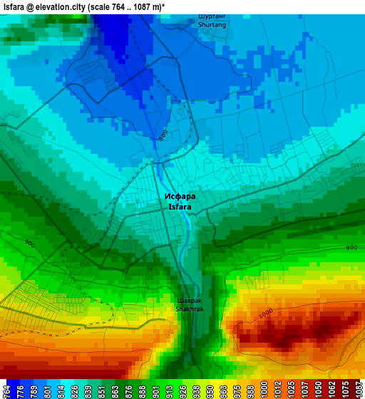
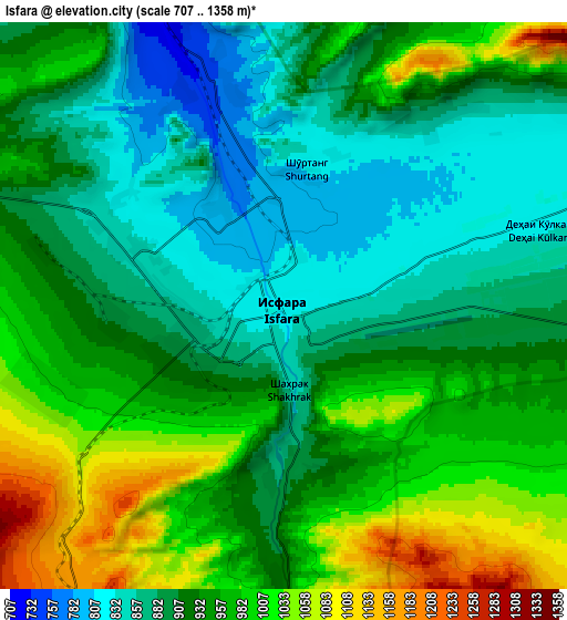
Below is the Elevation map of Isfara, which displays elevation range with different colors. Scale of the first map is from 764 to 1087 m (2507 to 3566 ft) with average elevation of 869.4 meters (=2852 ft) [note 1]
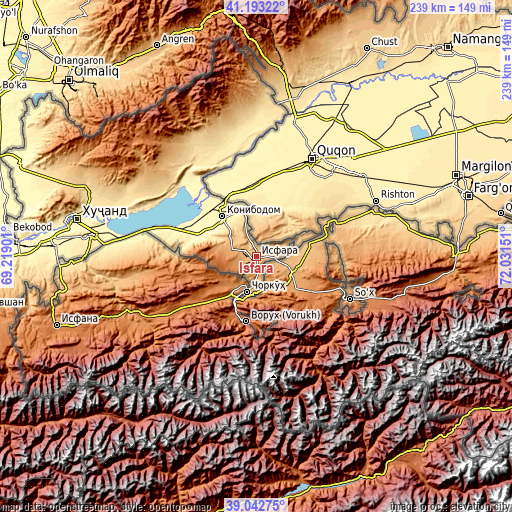
These maps also provides idea of topography and contour of this city, they are displayed at different zoom levels. More info about maps, scale and edge coordinates you can find below images.
| \ | Map #1 | Map #2 | Topo.Map |
| Scale [m] | 764..1087 m | 707..1358 m | × |
| Scale [ft] | 2507..3566 ft | 2320..4455 ft | × |
| Average | 869.4 m = 2852 ft | 933.9 m = 3064 ft | × |
| Width | 7.47 km = 4.6 mi | 14.94 km = 9.3 mi | 239.1 km = 148.6 mi |
| Height | 7.47 km = 4.6 mi | 14.94 km = 9.3 mi | 239.1 km = 148.6 mi |
| ↑Max Latitude | 40.160083° | 40.19366° | 41.19322° |
| Latitude at center | 40.12649° | 40.12649° | 40.12649° |
| ↓Min Latitude | 40.09288° | 40.059254° | 39.04275° |
| ← Min Longitude | 70.581315° | 70.537369° | 69.21901° |
| Longitude center | 70.62526° | 70.62526° | 70.62526° |
| →Max Longitude | 70.669205° | 70.713151° | 72.03151° |
Nearby cities:
Cities around Isfara sort by population:
• Khŭjand elevation 340 m
86.9 km,  281°
281°
• Konibodom 409 m
24.9 km,  318°
318°
• Chkalov 415 m
79.9 km, 278°
• Adrasmon 1599 m
79.5 km, 316°
• Shaydon 838 m
64.8 km,  338°
338°
• Konsoy 891 m
88.1 km,  297°
297°
• Neftobod 687 m
10.9 km, 335°
• Shŭrob 1248 m
11.5 km,  218°
218°
• Vorukh 1400 m
30.8 km,  187°
187°
• Palos 353 m
78.3 km,  285°
285°
• Kim 864 m
16.1 km, 304°
• Ghafurov 422 m
76.8 km, 277°
Multilingual:
 En español:
Isfara elevación 824 m.
 En France:
Isfara élévation 824 m.


Sources and notes:
- [note 1] Map square and city borders are not equal. Map elevation data is calculated only from area inside that square.
- [src 1] Elevation data from geonames database provided with same terms of usage.
- [src 2] The elevation map of Isfara is generated using elevation data from NASA's 3 arcsec (90m) resolution SRTM data.
- [src 3] Base (background) map © OpenStreetMap contributors tiles are generated by Geofabrik and OpenTopoMap.
Copyright & License:
This Isfara Elevation Map is licensed under CC BY-SA. You may reuse any part from this page, if you give a proper credit by linking to this URL:
 More info on terms of use page.