Khŭjand elevation
Khŭjand (Sughd), Tajikistan elevation is 340 meters and Khŭjand elevation in feet is 1115 ft above sea level [src 1]. Khŭjand is a seat of a first-order administrative division (feature code) with elevation that is 614 meters (2014 ft) smaller than average city elevation in Tajikistan.
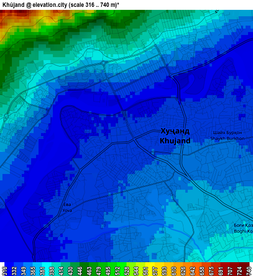
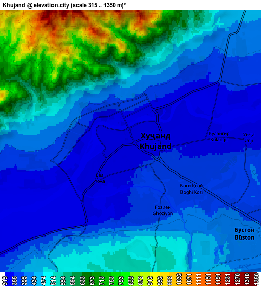
Below is the Elevation map of Khŭjand, which displays elevation range with different colors. Scale of the first map is from 316 to 740 m (1037 to 2428 ft) with average elevation of 365 meters (=1198 ft) [note 1]
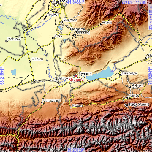
These maps also provides idea of topography and contour of this city, they are displayed at different zoom levels. More info about maps, scale and edge coordinates you can find below images.
| \ | Map #1 | Map #2 | Topo.Map |
| Scale [m] | 316..740 m | 315..1350 m | × |
| Scale [ft] | 1037..2428 ft | 1033..4429 ft | × |
| Average | 365 m = 1198 ft | 473 m = 1552 ft | × |
| Width | 7.46 km = 4.6 mi | 14.91 km = 9.3 mi | 238.6 km = 148.3 mi |
| Height | 7.46 km = 4.6 mi | 14.91 km = 9.3 mi | 238.6 km = 148.3 mi |
| ↑Max Latitude | 40.316076° | 40.349575° | 41.34681° |
| Latitude at center | 40.28256° | 40.28256° | 40.28256° |
| ↓Min Latitude | 40.249027° | 40.215478° | 39.20129° |
| ← Min Longitude | 69.578215° | 69.534269° | 68.21591° |
| Longitude center | 69.62216° | 69.62216° | 69.62216° |
| →Max Longitude | 69.666105° | 69.710051° | 71.02841° |
Nearby cities:
Cities around Khŭjand sort by population:
• Chkalov elevation 415 m
8.2 km,  131°
131°
• Proletar 382 m
16.4 km,  218°
218°
• Nov 379 m
25.8 km,  235°
235°
• Adrasmon 1599 m
51 km,  36°
36°
• Bŭston 324 m
36.2 km,  317°
317°
• Taboshar 1196 m
32 km,  2°
2°
• Konsoy 891 m
24.2 km,  16°
16°
• Oltintopkan 1259 m
41.4 km,  357°
357°
• Quruqsoy 433 m
38.6 km,  327°
327°
• Palos 353 m
10.5 km,  69°
69°
• Ghonchí 907 m
55 km,  229°
229°
• Ghafurov 422 m
11.7 km, 129°
Multilingual:
 En español:
Khodjent elevación 340 m.
 En France:
Khodjent élévation 340 m.
 Auf Deutsch:
Chudschand höhe über dem Meeresspiegel ist 340 m.

Sources and notes:
- [note 1] Map square and city borders are not equal. Map elevation data is calculated only from area inside that square.
- [src 1] Elevation data from geonames database provided with same terms of usage.
- [src 2] The elevation map of Khŭjand is generated using elevation data from NASA's 3 arcsec (90m) resolution SRTM data.
- [src 3] Base (background) map © OpenStreetMap contributors tiles are generated by Geofabrik and OpenTopoMap.
Copyright & License:
This Khŭjand Elevation Map is licensed under CC BY-SA. You may reuse any part from this page, if you give a proper credit by linking to this URL:
 More info on terms of use page.