Bamnet Narong elevation
Bamnet Narong (Chaiyaphum), Thailand elevation is 213 meters and Bamnet Narong elevation in feet is 699 ft above sea level [src 1]. Bamnet Narong is a seat of a second-order administrative division (feature code) with elevation that is 88 meters (289 ft) bigger than average city elevation in Thailand.
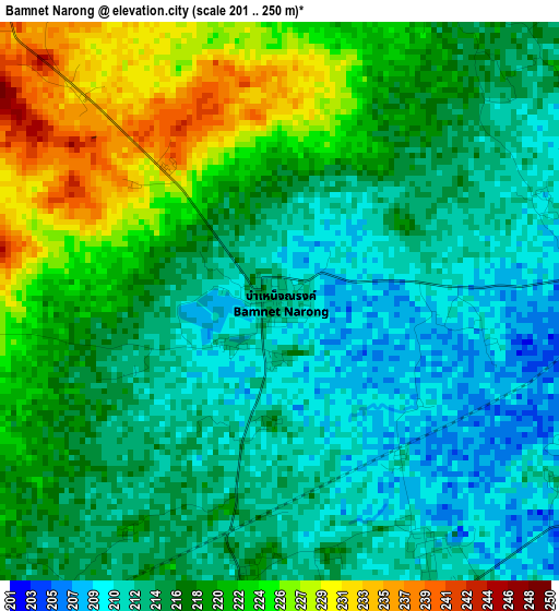
Below is the Elevation map of Bamnet Narong, which displays elevation range with different colors. Scale of the first map is from 201 to 250 m (659 to 820 ft) with average elevation of 217.1 meters (=712 ft) [note 1]
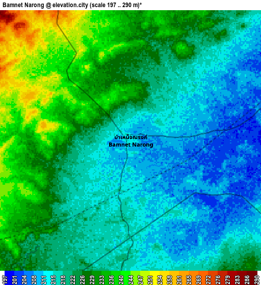
These maps also provides idea of topography and contour of this city, they are displayed at different zoom levels. More info about maps, scale and edge coordinates you can find below images.
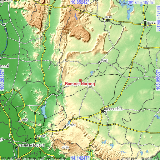
| \ | Map #1 | Map #2 | Topo.Map |
| Scale [m] | 201..250 m | 197..290 m | × |
| Scale [ft] | 659..820 ft | 646..951 ft | × |
| Average | 217.1 m = 712 ft | 223.1 m = 732 ft | × |
| Width | 9.42 km = 5.9 mi | 18.83 km = 11.7 mi | 301.3 km = 187.2 mi |
| Height | 9.42 km = 5.9 mi | 18.83 km = 11.7 mi | 301.3 km = 187.2 mi |
| ↑Max Latitude | 15.544232° | 15.586566° | 16.85242° |
| Latitude at center | 15.50189° | 15.50189° | 15.50189° |
| ↓Min Latitude | 15.459539° | 15.417179° | 14.14247° |
| ← Min Longitude | 101.645875° | 101.601929° | 100.28357° |
| Longitude center | 101.68982° | 101.68982° | 101.68982° |
| →Max Longitude | 101.733765° | 101.777711° | 103.09607° |
Nearby cities:
Cities around Bamnet Narong sort by population:
• Chaiyaphum elevation 188 m
49.9 km,  46°
46°
• Dan Khun Thot 214 m
33.8 km,  164°
164°
• Ban Lueam 194 m
48.6 km,  75°
75°
• Phra Thong Kham 190 m
44 km,  126°
126°
• Lam Sonthi 85 m
41.5 km,  237°
237°
• Ban Khwao 202 m
38.5 km,  37°
37°
• Noen Sa-nga 211 m
34.1 km, 78°
• Nong Bua Rawe 211 m
29 km,  15°
15°
• Thep Sathit 317 m
28.4 km, 244°
• Thepharak 282 m
26.2 km,  214°
214°
• Chatturat 196 m
18.1 km,  67°
67°
• Sap Yai 344 m
17 km,  332°
332°
Multilingual:
 En español:
Bamnet Narong elevación 213 m.
 En France:
Bamnet Narong élévation 213 m.
 Auf Deutsch:
Bamnet Narong höhe über dem Meeresspiegel ist 213 m.

Sources and notes:
- [note 1] Map square and city borders are not equal. Map elevation data is calculated only from area inside that square.
- [src 1] Elevation data from geonames database provided with same terms of usage.
- [src 2] The elevation map of Bamnet Narong is generated using elevation data from NASA's 3 arcsec (90m) resolution SRTM data.
- [src 3] Base (background) map © OpenStreetMap contributors tiles are generated by Geofabrik and OpenTopoMap.
Copyright & License:
This Bamnet Narong Elevation Map is licensed under CC BY-SA. You may reuse any part from this page, if you give a proper credit by linking to this URL:
 More info on terms of use page.