Chaiyaphum elevation
Chaiyaphum, Thailand elevation is 188 meters and Chaiyaphum elevation in feet is 617 ft above sea level [src 1]. Chaiyaphum is a seat of a first-order administrative division (feature code) with elevation that is 63 meters (207 ft) bigger than average city elevation in Thailand.
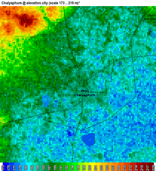
Below is the Elevation map of Chaiyaphum, which displays elevation range with different colors. Scale of the first map is from 173 to 219 m (568 to 719 ft) with average elevation of 185.5 meters (=609 ft) [note 1]
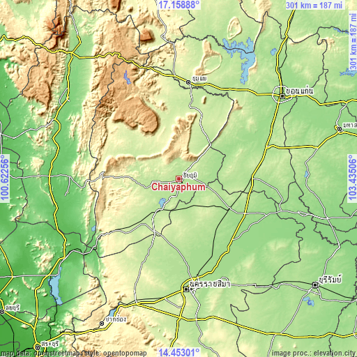
These maps also provides idea of topography and contour of this city, they are displayed at different zoom levels. More info about maps, scale and edge coordinates you can find below images.
| \ | Map #1 | Map #2 | Topo.Map |
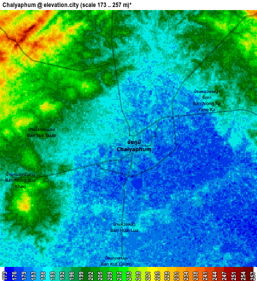
| Scale [m] | 173..219 m | 173..257 m | × |
| Scale [ft] | 568..719 ft | 568..843 ft | × |
| Average | 185.5 m = 609 ft | 192.7 m = 632 ft | × |
| Width | 9.4 km = 5.8 mi | 18.81 km = 11.7 mi | 300.9 km = 187 mi |
| Height | 9.4 km = 5.8 mi | 18.81 km = 11.7 mi | 300.9 km = 187 mi |
| ↑Max Latitude | 15.852748° | 15.895018° | 17.15888° |
| Latitude at center | 15.81047° | 15.81047° | 15.81047° |
| ↓Min Latitude | 15.768183° | 15.725887° | 14.45301° |
| ← Min Longitude | 101.984865° | 101.940919° | 100.62256° |
| Longitude center | 102.02881° | 102.02881° | 102.02881° |
| →Max Longitude | 102.072755° | 102.116701° | 103.43506° |
Nearby cities:
Cities around Chaiyaphum sort by population:
• Kaeng Khro elevation 205 m
41.2 km,  36°
36°
• Bua Yai 177 m
49.3 km,  120°
120°
• Sap Yai 344 m
48.1 km,  246°
246°
• Waeng Noi 197 m
41.4 km,  91°
91°
• Nong Bua Daeng 254 m
38.5 km,  321°
321°
• Chatturat 196 m
33.6 km,  215°
215°
• Khon Sawan 189 m
30.2 km,  63°
63°
• Nong Bua Rawe 211 m
29 km,  257°
257°
• Noen Sa-nga 211 m
27.5 km,  186°
186°
• Kaeng Sanam Nang 182 m
25.1 km,  105°
105°
• Ban Lueam 194 m
24.8 km,  154°
154°
• Ban Khwao 202 m
13.5 km, 254°
Multilingual:
 En español:
Chaiyaphum elevación 188 m.
 En France:
Chaiyaphum élévation 188 m.
 Auf Deutsch:
Chaiyaphum höhe über dem Meeresspiegel ist 188 m.

Sources and notes:
- [note 1] Map square and city borders are not equal. Map elevation data is calculated only from area inside that square.
- [src 1] Elevation data from geonames database provided with same terms of usage.
- [src 2] The elevation map of Chaiyaphum is generated using elevation data from NASA's 3 arcsec (90m) resolution SRTM data.
- [src 3] Base (background) map © OpenStreetMap contributors tiles are generated by Geofabrik and OpenTopoMap.
Copyright & License:
This Chaiyaphum Elevation Map is licensed under CC BY-SA. You may reuse any part from this page, if you give a proper credit by linking to this URL:
 More info on terms of use page.