Ban Phe elevation
Ban Phe (Rayong), Thailand elevation is 7 meters and Ban Phe elevation in feet is 23 ft above sea level [src 1]. Ban Phe is a populated place (feature code) with elevation that is 118 meters (387 ft) smaller than average city elevation in Thailand.
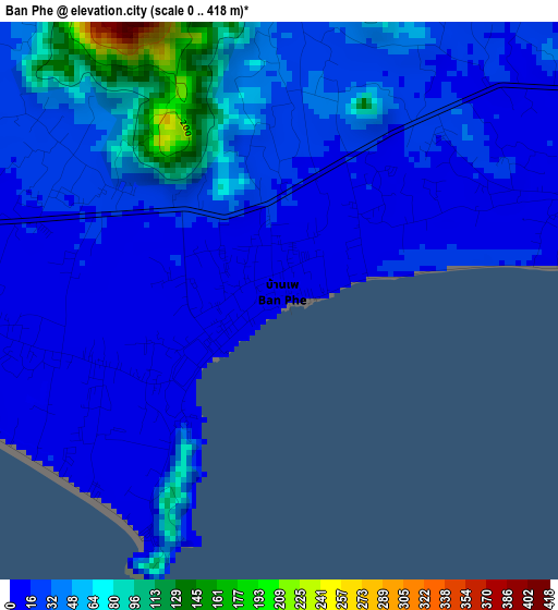
Below is the Elevation map of Ban Phe, which displays elevation range with different colors. Scale of the first map is from 0 to 418 m (0 to 1371 ft) with average elevation of 33.3 meters (=109 ft) [note 1]
These maps also provides idea of topography and contour of this city, they are displayed at different zoom levels. More info about maps, scale and edge coordinates you can find below images.
| \ | Map #1 | Map #2 | Topo.Map |
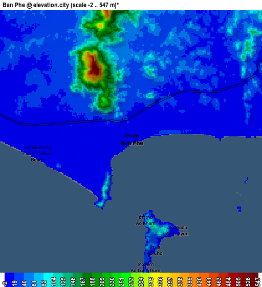
| Scale [m] | 0..418 m | -2..547 m | × |
| Scale [ft] | 0..1371 ft | -7..1795 ft | × |
| Average | 33.3 m = 109 ft | 40.7 m = 134 ft | × |
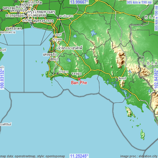
| Width | 9.54 km = 5.9 mi | 19.07 km = 11.8 mi | 305.1 km = 189.6 mi |
| Height | 9.54 km = 5.9 mi | 19.07 km = 11.8 mi | 305.2 km = 189.6 mi |
| ↑Max Latitude | 12.671119° | 12.71399° | 13.99667° |
| Latitude at center | 12.62824° | 12.62824° | 12.62824° |
| ↓Min Latitude | 12.585354° | 12.542461° | 11.25245° |
| ← Min Longitude | 101.393625° | 101.349679° | 100.03132° |
| Longitude center | 101.43757° | 101.43757° | 101.43757° |
| →Max Longitude | 101.481515° | 101.525461° | 102.84382° |
Nearby cities:
Cities around Ban Phe sort by population:
• Rayong elevation 7 m
20.3 km,  286°
286°
• Sattahip 4 m
58.4 km,  274°
274°
• Klaeng 11 m
28.4 km,  53°
53°
• Ban Chang 49 m
42.9 km,  284°
284°
• Tha Mai 4 m
61.6 km,  90°
90°
• Nong Yai 80 m
59 km,  353°
353°
• Khao Chamao 48 m
47.1 km,  34°
34°
• Pluak Daeng 60 m
45.2 km,  327°
327°
• Na Yai Am 16 m
45.1 km,  67°
67°
• Wang Chan 41 m
35.5 km,  15°
15°
• Nikhom Phattana 72 m
33.7 km,  310°
310°
• Ban Khai 15 m
23 km,  318°
318°
Multilingual:
 En español:
Ban Phe elevación 7 m.
 En France:
Ban Phe élévation 7 m.


Sources and notes:
- [note 1] Map square and city borders are not equal. Map elevation data is calculated only from area inside that square.
- [src 1] Elevation data from geonames database provided with same terms of usage.
- [src 2] The elevation map of Ban Phe is generated using elevation data from NASA's 3 arcsec (90m) resolution SRTM data.
- [src 3] Base (background) map © OpenStreetMap contributors tiles are generated by Geofabrik and OpenTopoMap.
Copyright & License:
This Ban Phe Elevation Map is licensed under CC BY-SA. You may reuse any part from this page, if you give a proper credit by linking to this URL:
 More info on terms of use page.