Tha Mai elevation
Tha Mai (Chanthaburi), Thailand elevation is 4 meters and Tha Mai elevation in feet is 13 ft above sea level [src 1]. Tha Mai is a seat of a second-order administrative division (feature code) with elevation that is 121 meters (397 ft) smaller than average city elevation in Thailand.
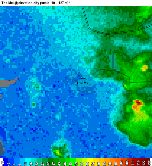
Below is the Elevation map of Tha Mai, which displays elevation range with different colors. Scale of the first map is from -10 to 127 m (-33 to 417 ft) with average elevation of 14.8 meters (=49 ft) [note 1]
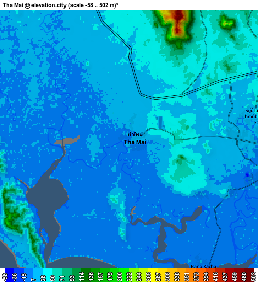
These maps also provides idea of topography and contour of this city, they are displayed at different zoom levels. More info about maps, scale and edge coordinates you can find below images.
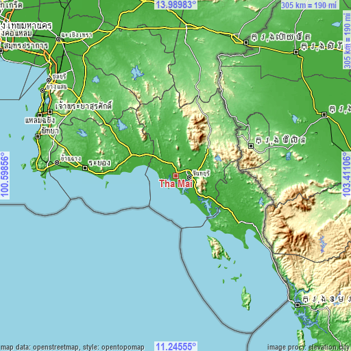
| \ | Map #1 | Map #2 | Topo.Map |
| Scale [m] | -10..127 m | -58..502 m | × |
| Scale [ft] | -33..417 ft | -190..1647 ft | × |
| Average | 14.8 m = 49 ft | 21.8 m = 72 ft | × |
| Width | 9.54 km = 5.9 mi | 19.07 km = 11.8 mi | 305.1 km = 189.6 mi |
| Height | 9.54 km = 5.9 mi | 19.07 km = 11.8 mi | 305.2 km = 189.6 mi |
| ↑Max Latitude | 12.66425° | 12.707122° | 13.98983° |
| Latitude at center | 12.62137° | 12.62137° | 12.62137° |
| ↓Min Latitude | 12.578483° | 12.535589° | 11.24555° |
| ← Min Longitude | 101.960865° | 101.916919° | 100.59856° |
| Longitude center | 102.00481° | 102.00481° | 102.00481° |
| →Max Longitude | 102.048755° | 102.092701° | 103.41106° |
Nearby cities:
Cities around Tha Mai sort by population:
• Chanthaburi elevation 7 m
10.9 km,  96°
96°
• Klaeng 11 m
42.5 km,  294°
294°
• Laem Sing 6 m
17.2 km,  154°
154°
• Bo Rai 29 m
58 km, 95°
• Khlung 8 m
29.9 km,  128°
128°
• Pong Nam Ron 252 m
42.2 km,  41°
41°
• Khao Saming 14 m
55.4 km,  122°
122°
• Khao Chamao 48 m
52.5 km,  318°
318°
• Kaeng Hang Maeo 33 m
44.3 km,  346°
346°
• Na Yai Am 16 m
26.6 km,  312°
312°
• Khao Khitchakut 20 m
23.6 km,  30°
30°
• Makham 11 m
21.5 km,  74°
74°
Multilingual:
 En español:
Tha Mai elevación 4 m.
 En France:
Tha Mai élévation 4 m.


Sources and notes:
- [note 1] Map square and city borders are not equal. Map elevation data is calculated only from area inside that square.
- [src 1] Elevation data from geonames database provided with same terms of usage.
- [src 2] The elevation map of Tha Mai is generated using elevation data from NASA's 3 arcsec (90m) resolution SRTM data.
- [src 3] Base (background) map © OpenStreetMap contributors tiles are generated by Geofabrik and OpenTopoMap.
Copyright & License:
This Tha Mai Elevation Map is licensed under CC BY-SA. You may reuse any part from this page, if you give a proper credit by linking to this URL:
 More info on terms of use page.