Ban Selaphum elevation
Ban Selaphum (Roi Et), Thailand elevation is 133 meters and Ban Selaphum elevation in feet is 436 ft above sea level [src 1]. Ban Selaphum is a populated place (feature code) with elevation that is 8 meters (26 ft) bigger than average city elevation in Thailand.
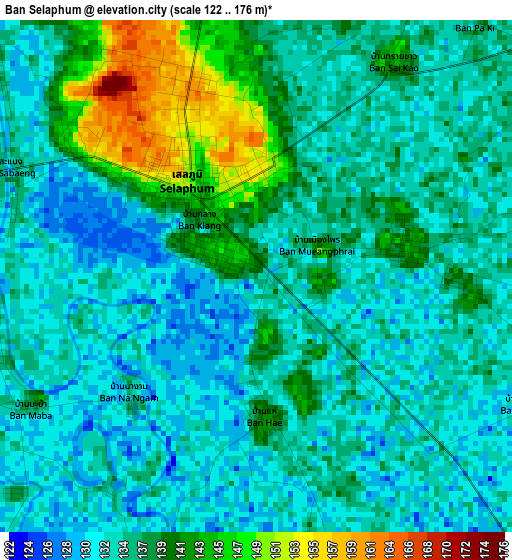
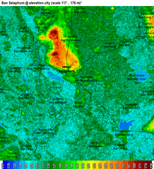
Below is the Elevation map of Ban Selaphum, which displays elevation range with different colors. Scale of the first map is from 122 to 176 m (400 to 577 ft) with average elevation of 136 meters (=446 ft) [note 1]
These maps also provides idea of topography and contour of this city, they are displayed at different zoom levels. More info about maps, scale and edge coordinates you can find below images.
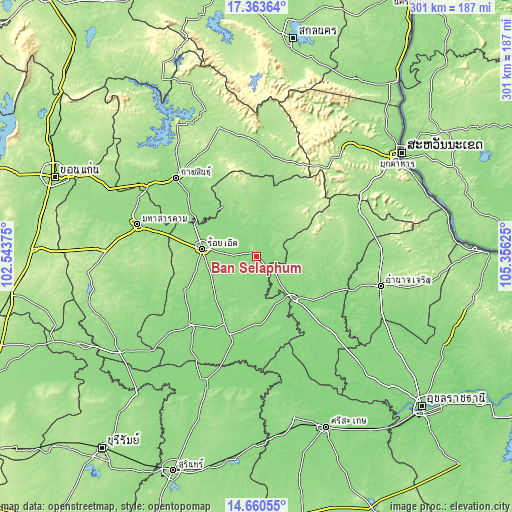
| \ | Map #1 | Map #2 | Topo.Map |
| Scale [m] | 122..176 m | 117..176 m | × |
| Scale [ft] | 400..577 ft | 384..577 ft | × |
| Average | 136 m = 446 ft | 134.1 m = 440 ft | × |
| Width | 9.39 km = 5.8 mi | 18.79 km = 11.7 mi | 300.6 km = 186.8 mi |
| Height | 9.39 km = 5.8 mi | 18.79 km = 11.7 mi | 300.6 km = 186.8 mi |
| ↑Max Latitude | 16.058905° | 16.101131° | 17.36364° |
| Latitude at center | 16.01667° | 16.01667° | 16.01667° |
| ↓Min Latitude | 15.974426° | 15.932173° | 14.66055° |
| ← Min Longitude | 103.906055° | 103.862109° | 102.54375° |
| Longitude center | 103.95° | 103.95° | 103.95° |
| →Max Longitude | 103.993945° | 104.037891° | 105.35625° |
Nearby cities:
Cities around Ban Selaphum sort by population:
• Roi Et elevation 148 m
32 km,  277°
277°
• Yasothon 135 m
32.4 km,  139°
139°
• Waeng 148 m
31.7 km,  5°
5°
• Changhan 150 m
39.4 km,  290°
290°
• Rong Kham 147 m
35.5 km,  322°
322°
• Mueang Suang 157 m
32.1 km,  227°
227°
• Sai Mun 156 m
28.7 km,  106°
106°
• Chiang Khwan 139 m
26.6 km,  307°
307°
• Thawat Buri 146 m
21.9 km, 276°
• At Samat 140 m
20.8 km,  201°
201°
• Thung Khao Luang 131 m
9.7 km,  254°
254°
• Selaphum 144 m
1.9 km, 319°
Multilingual:
 En español:
Ban Selaphum elevación 133 m.
 En France:
Ban Selaphum élévation 133 m.
 Auf Deutsch:
Ban Selaphum höhe über dem Meeresspiegel ist 133 m.

Sources and notes:
- [note 1] Map square and city borders are not equal. Map elevation data is calculated only from area inside that square.
- [src 1] Elevation data from geonames database provided with same terms of usage.
- [src 2] The elevation map of Ban Selaphum is generated using elevation data from NASA's 3 arcsec (90m) resolution SRTM data.
- [src 3] Base (background) map © OpenStreetMap contributors tiles are generated by Geofabrik and OpenTopoMap.
Copyright & License:
This Ban Selaphum Elevation Map is licensed under CC BY-SA. You may reuse any part from this page, if you give a proper credit by linking to this URL:
 More info on terms of use page.