Chom Phra elevation
Chom Phra (Surin), Thailand elevation is 141 meters and Chom Phra elevation in feet is 463 ft above sea level [src 1]. Chom Phra is a seat of a second-order administrative division (feature code) with elevation that is 16 meters (52 ft) bigger than average city elevation in Thailand.
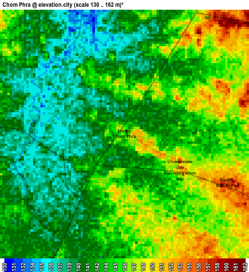
Below is the Elevation map of Chom Phra, which displays elevation range with different colors. Scale of the first map is from 130 to 162 m (427 to 531 ft) with average elevation of 143.2 meters (=470 ft) [note 1]
These maps also provides idea of topography and contour of this city, they are displayed at different zoom levels. More info about maps, scale and edge coordinates you can find below images.
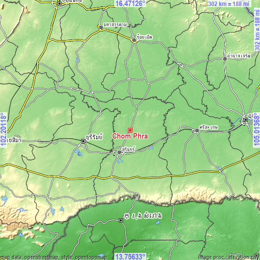
| \ | Map #1 | Topo.Map |
| Scale [m] | 130..162 m | × |
| Scale [ft] | 427..531 ft | × |
| Average | 143.2 m = 470 ft | × |
| Width | 9.43 km = 5.9 mi | 301.9 km = 187.6 mi |
| Height | 9.43 km = 5.9 mi | 301.9 km = 187.6 mi |
| ↑Max Latitude | 15.16056° | 16.47126° |
| Latitude at center | 15.11814° | 15.11814° |
| ↓Min Latitude | 15.075711° | 13.75633° |
| ← Min Longitude | 103.563485° | 102.20118° |
| Longitude center | 103.60743° | 103.60743° |
| →Max Longitude | 103.651375° | 105.01368° |
Nearby cities:
Cities around Chom Phra sort by population:
• Surin elevation 150 m
29 km,  204°
204°
• Satuek 135 m
39.3 km,  300°
300°
• Lamduan 159 m
44.5 km,  171°
171°
• Krasang 155 m
39.1 km,  236°
236°
• Samrong Thap 136 m
36.9 km,  106°
106°
• Non Narai 138 m
35.4 km,  67°
67°
• Chumphon Buri 133 m
34.5 km,  317°
317°
• Rattanaburi 148 m
34.1 km,  49°
49°
• Si Khoraphum 143 m
28.1 km,  133°
133°
• Tha Tum 132 m
23.5 km,  18°
18°
• Sanom 150 m
19 km,  59°
59°
• Khwao Sinarin 150 m
13 km,  187°
187°
Multilingual:
 En español:
Chom Phra elevación 141 m.
 En France:
Chom Phra élévation 141 m.
 Auf Deutsch:
Chom Phra höhe über dem Meeresspiegel ist 141 m.

Sources and notes:
- [note 1] Map square and city borders are not equal. Map elevation data is calculated only from area inside that square.
- [src 1] Elevation data from geonames database provided with same terms of usage.
- [src 2] The elevation map of Chom Phra is generated using elevation data from NASA's 3 arcsec (90m) resolution SRTM data.
- [src 3] Base (background) map © OpenStreetMap contributors tiles are generated by Geofabrik and OpenTopoMap.
Copyright & License:
This Chom Phra Elevation Map is licensed under CC BY-SA. You may reuse any part from this page, if you give a proper credit by linking to this URL:
 More info on terms of use page.