Samrong Thap elevation
Samrong Thap (Surin), Thailand elevation is 136 meters and Samrong Thap elevation in feet is 446 ft above sea level [src 1]. Samrong Thap is a seat of a second-order administrative division (feature code) with elevation that is 11 meters (36 ft) bigger than average city elevation in Thailand.
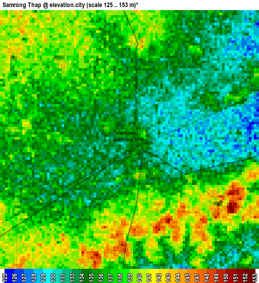
Below is the Elevation map of Samrong Thap, which displays elevation range with different colors. Scale of the first map is from 125 to 153 m (410 to 502 ft) with average elevation of 136.1 meters (=447 ft) [note 1]
These maps also provides idea of topography and contour of this city, they are displayed at different zoom levels. More info about maps, scale and edge coordinates you can find below images.
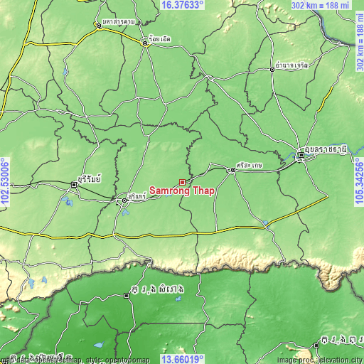
| \ | Map #1 | Topo.Map |
| Scale [m] | 125..153 m | × |
| Scale [ft] | 410..502 ft | × |
| Average | 136.1 m = 447 ft | × |
| Width | 9.44 km = 5.9 mi | 302 km = 187.7 mi |
| Height | 9.44 km = 5.9 mi | 302 km = 187.7 mi |
| ↑Max Latitude | 15.065019° | 16.37633° |
| Latitude at center | 15.02258° | 15.02258° |
| ↓Min Latitude | 14.980132° | 13.66019° |
| ← Min Longitude | 103.892365° | 102.53006° |
| Longitude center | 103.93631° | 103.93631° |
| →Max Longitude | 103.980255° | 105.34256° |
Nearby cities:
Cities around Samrong Thap sort by population:
• Bueng Bun elevation 128 m
36.1 km,  18°
18°
• Rattanaburi 148 m
34.2 km,  344°
344°
• Wang Hin 139 m
32.7 km,  104°
104°
• Si Narong 155 m
29.2 km,  193°
193°
• Sanom 150 m
27.6 km,  316°
316°
• Pho Si Suwan 139 m
27.5 km,  33°
33°
• Non Narai 138 m
24 km,  354°
354°
• Uthumphon Phisai 142 m
24 km,  65°
65°
• Prang Ku 142 m
21.5 km,  148°
148°
• Mueang Chan 141 m
18.6 km,  35°
35°
• Si Khoraphum 143 m
17.3 km,  239°
239°
• Huai Thap Than 136 m
10.4 km, 70°
Multilingual:
 En español:
Samrong Thap elevación 136 m.
 En France:
Samrong Thap élévation 136 m.
 Auf Deutsch:
Samrong Thap höhe über dem Meeresspiegel ist 136 m.

Sources and notes:
- [note 1] Map square and city borders are not equal. Map elevation data is calculated only from area inside that square.
- [src 1] Elevation data from geonames database provided with same terms of usage.
- [src 2] The elevation map of Samrong Thap is generated using elevation data from NASA's 3 arcsec (90m) resolution SRTM data.
- [src 3] Base (background) map © OpenStreetMap contributors tiles are generated by Geofabrik and OpenTopoMap.
Copyright & License:
This Samrong Thap Elevation Map is licensed under CC BY-SA. You may reuse any part from this page, if you give a proper credit by linking to this URL:
 More info on terms of use page.