Kamalasai elevation
Kamalasai (Kalasin), Thailand elevation is 146 meters and Kamalasai elevation in feet is 479 ft above sea level [src 1]. Kamalasai is a seat of a second-order administrative division (feature code) with elevation that is 21 meters (69 ft) bigger than average city elevation in Thailand.
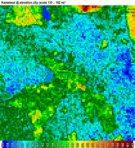
Below is the Elevation map of Kamalasai, which displays elevation range with different colors. Scale of the first map is from 133 to 162 m (436 to 531 ft) with average elevation of 141 meters (=463 ft) [note 1]
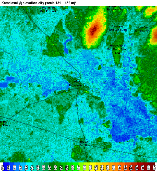
These maps also provides idea of topography and contour of this city, they are displayed at different zoom levels. More info about maps, scale and edge coordinates you can find below images.
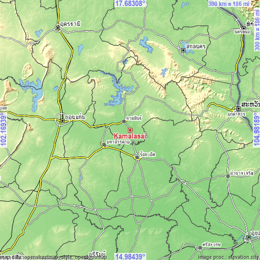
| \ | Map #1 | Map #2 | Topo.Map |
| Scale [m] | 133..162 m | 131..182 m | × |
| Scale [ft] | 436..531 ft | 430..597 ft | × |
| Average | 141 m = 463 ft | 142.7 m = 468 ft | × |
| Width | 9.38 km = 5.8 mi | 18.76 km = 11.7 mi | 300.1 km = 186.5 mi |
| Height | 9.38 km = 5.8 mi | 18.76 km = 11.7 mi | 300.1 km = 186.5 mi |
| ↑Max Latitude | 16.380556° | 16.422713° | 17.68308° |
| Latitude at center | 16.33839° | 16.33839° | 16.33839° |
| ↓Min Latitude | 16.296215° | 16.25403° | 14.98439° |
| ← Min Longitude | 103.531695° | 103.487749° | 102.16939° |
| Longitude center | 103.57564° | 103.57564° | 103.57564° |
| →Max Longitude | 103.619585° | 103.663531° | 104.98189° |
Nearby cities:
Cities around Kamalasai sort by population:
• Kalasin elevation 152 m
12.8 km,  324°
324°
• Maha Sarakham 155 m
34 km,  239°
239°
• Roi Et 148 m
32.4 km,  165°
165°
• Pho Chai 162 m
20.8 km,  93°
93°
• Yang Talat 148 m
23.2 km,  287°
287°
• Na Mon 184 m
34.8 km,  40°
40°
• Kantharawichai 158 m
29.6 km,  267°
267°
• Chiang Khwan 139 m
27.2 km,  135°
135°
• Changhan 150 m
22.4 km, 172°
• Rong Kham 147 m
19.8 km,  112°
112°
• Don Chan 174 m
18.4 km, 44°
• Khong Chai 148 m
15.2 km, 235°
Multilingual:
 En español:
Kamalasai elevación 146 m.
 En France:
Kamalasai élévation 146 m.
 Auf Deutsch:
Kamalasai höhe über dem Meeresspiegel ist 146 m.

Sources and notes:
- [note 1] Map square and city borders are not equal. Map elevation data is calculated only from area inside that square.
- [src 1] Elevation data from geonames database provided with same terms of usage.
- [src 2] The elevation map of Kamalasai is generated using elevation data from NASA's 3 arcsec (90m) resolution SRTM data.
- [src 3] Base (background) map © OpenStreetMap contributors tiles are generated by Geofabrik and OpenTopoMap.
Copyright & License:
This Kamalasai Elevation Map is licensed under CC BY-SA. You may reuse any part from this page, if you give a proper credit by linking to this URL:
 More info on terms of use page.