Khon Kaen elevation
Khon Kaen, Thailand elevation is 167 meters and Khon Kaen elevation in feet is 548 ft above sea level [src 1]. Khon Kaen is a seat of a first-order administrative division (feature code) with elevation that is 42 meters (138 ft) bigger than average city elevation in Thailand.
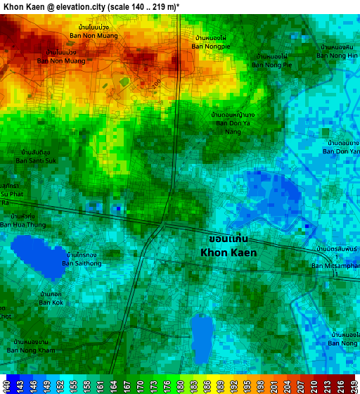
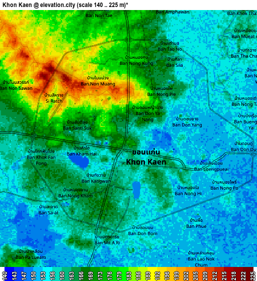
Below is the Elevation map of Khon Kaen, which displays elevation range with different colors. Scale of the first map is from 140 to 219 m (459 to 719 ft) with average elevation of 166.9 meters (=548 ft) [note 1]
These maps also provides idea of topography and contour of this city, they are displayed at different zoom levels. More info about maps, scale and edge coordinates you can find below images.
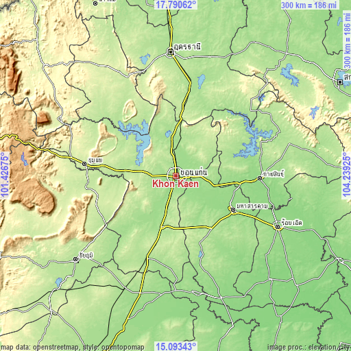
| \ | Map #1 | Map #2 | Topo.Map |
| Scale [m] | 140..219 m | 140..225 m | × |
| Scale [ft] | 459..719 ft | 459..738 ft | × |
| Average | 166.9 m = 548 ft | 164.2 m = 539 ft | × |
| Width | 9.37 km = 5.8 mi | 18.75 km = 11.7 mi | 299.9 km = 186.3 mi |
| Height | 9.37 km = 5.8 mi | 18.75 km = 11.7 mi | 299.9 km = 186.3 mi |
| ↑Max Latitude | 16.488853° | 16.530986° | 17.79062° |
| Latitude at center | 16.44671° | 16.44671° | 16.44671° |
| ↓Min Latitude | 16.404558° | 16.362397° | 15.09343° |
| ← Min Longitude | 102.789055° | 102.745109° | 101.42675° |
| Longitude center | 102.833° | 102.833° | 102.833° |
| →Max Longitude | 102.876945° | 102.920891° | 104.23925° |
Nearby cities:
Cities around Khon Kaen sort by population:
• Kranuan elevation 218 m
39 km,  42°
42°
• Kosum Phisai 160 m
33.3 km,  131°
131°
• Nong Ruea 200 m
42.9 km,  276°
276°
• Khuean Ubonrat 198 m
40.2 km,  327°
327°
• Ubonratana 198 m
40.2 km, 327°
• Chuen Chom 200 m
38.6 km,  71°
71°
• Ban Haet 169 m
28.9 km,  195°
195°
• Chiang Yuen 177 m
28.5 km,  98°
98°
• Nam Phong 172 m
28.5 km,  4°
4°
• Sam Sung 191 m
28.4 km, 67°
• Phra Yuen 178 m
23.3 km,  235°
235°
• Ban Fang 190 m
20.7 km,  272°
272°
Multilingual:
 En español:
Khon Kaen elevación 167 m.
 En France:
Khon Kaen élévation 167 m.
 Auf Deutsch:
Khon Kaen höhe über dem Meeresspiegel ist 167 m.

Sources and notes:
- [note 1] Map square and city borders are not equal. Map elevation data is calculated only from area inside that square.
- [src 1] Elevation data from geonames database provided with same terms of usage.
- [src 2] The elevation map of Khon Kaen is generated using elevation data from NASA's 3 arcsec (90m) resolution SRTM data.
- [src 3] Base (background) map © OpenStreetMap contributors tiles are generated by Geofabrik and OpenTopoMap.
Copyright & License:
This Khon Kaen Elevation Map is licensed under CC BY-SA. You may reuse any part from this page, if you give a proper credit by linking to this URL:
 More info on terms of use page.