Muang Sam Sip elevation
Muang Sam Sip (Changwat Ubon Ratchathani), Thailand elevation is 143 meters and Muang Sam Sip elevation in feet is 469 ft above sea level [src 1]. Muang Sam Sip is a seat of a second-order administrative division (feature code) with elevation that is 18 meters (59 ft) bigger than average city elevation in Thailand.
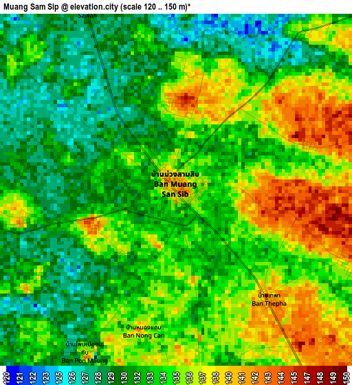
Below is the Elevation map of Muang Sam Sip, which displays elevation range with different colors. Scale of the first map is from 120 to 150 m (394 to 492 ft) with average elevation of 133.5 meters (=438 ft) [note 1]
These maps also provides idea of topography and contour of this city, they are displayed at different zoom levels. More info about maps, scale and edge coordinates you can find below images.
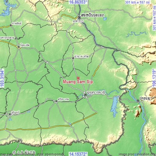
| \ | Map #1 | Topo.Map |
| Scale [m] | 120..150 m | × |
| Scale [ft] | 394..492 ft | × |
| Average | 133.5 m = 438 ft | × |
| Width | 9.42 km = 5.9 mi | 301.3 km = 187.2 mi |
| Height | 9.42 km = 5.9 mi | 301.3 km = 187.2 mi |
| ↑Max Latitude | 15.55541° | 16.86353° |
| Latitude at center | 15.51307° | 15.51307° |
| ↓Min Latitude | 15.470721° | 14.15372° |
| ← Min Longitude | 104.681705° | 103.3194° |
| Longitude center | 104.72565° | 104.72565° |
| →Max Longitude | 104.769595° | 106.1319° |
Nearby cities:
Cities around Muang Sam Sip sort by population:
• Ubon Ratchathani elevation 125 m
33.3 km,  156°
156°
• Warin Chamrap 136 m
38.5 km, 157°
• Amnat Charoen 161 m
39.8 km,  344°
344°
• Kho Wang 137 m
43.1 km,  248°
248°
• Kut Khaopun 155 m
42.6 km,  43°
43°
• Don Mot Daeng 126 m
35.7 km,  114°
114°
• Trakan Phut Phon 136 m
33.5 km,  70°
70°
• Hua Taphan 140 m
32.4 km,  309°
309°
• Lao Suea Kok 141 m
23.7 km,  116°
116°
• Khueang Nai 131 m
23.2 km,  233°
233°
• Phana 141 m
22.8 km,  34°
34°
• Lue Amnat 128 m
21.8 km, 337°
Multilingual:
 En español:
Muang Sam Sip elevación 143 m.
 En France:
Muang Sam Sip élévation 143 m.
 Auf Deutsch:
Muang Sam Sip höhe über dem Meeresspiegel ist 143 m.

Sources and notes:
- [note 1] Map square and city borders are not equal. Map elevation data is calculated only from area inside that square.
- [src 1] Elevation data from geonames database provided with same terms of usage.
- [src 2] The elevation map of Muang Sam Sip is generated using elevation data from NASA's 3 arcsec (90m) resolution SRTM data.
- [src 3] Base (background) map © OpenStreetMap contributors tiles are generated by Geofabrik and OpenTopoMap.
Copyright & License:
This Muang Sam Sip Elevation Map is licensed under CC BY-SA. You may reuse any part from this page, if you give a proper credit by linking to this URL:
 More info on terms of use page.