Phang Khon elevation
Phang Khon (Sakon Nakhon), Thailand elevation is 169 meters and Phang Khon elevation in feet is 554 ft above sea level [src 1]. Phang Khon is a seat of a second-order administrative division (feature code) with elevation that is 44 meters (144 ft) bigger than average city elevation in Thailand.
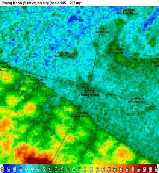
Below is the Elevation map of Phang Khon, which displays elevation range with different colors. Scale of the first map is from 155 to 207 m (509 to 679 ft) with average elevation of 170.6 meters (=560 ft) [note 1]
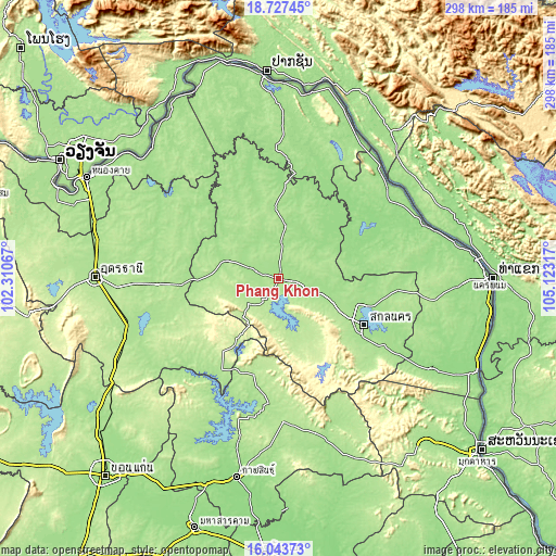
These maps also provides idea of topography and contour of this city, they are displayed at different zoom levels. More info about maps, scale and edge coordinates you can find below images.
| \ | Map #1 | Topo.Map |
| Scale [m] | 155..207 m | × |
| Scale [ft] | 509..679 ft | × |
| Average | 170.6 m = 560 ft | × |
| Width | 9.33 km = 5.8 mi | 298.4 km = 185.4 mi |
| Height | 9.33 km = 5.8 mi | 298.4 km = 185.4 mi |
| ↑Max Latitude | 17.432442° | 18.72745° |
| Latitude at center | 17.39051° | 17.39051° |
| ↓Min Latitude | 17.348569° | 16.04373° |
| ← Min Longitude | 103.672975° | 102.31067° |
| Longitude center | 103.71692° | 103.71692° |
| →Max Longitude | 103.760865° | 105.12317° |
Nearby cities:
Cities around Phang Khon sort by population:
• Sawang Daen Din elevation 169 m
29.1 km,  288°
288°
• Na Wa 160 m
42.2 km,  74°
74°
• Phu Phan 288 m
51.4 km,  147°
147°
• Thung Fon 171 m
49.3 km,  280°
280°
• Akat Amnuai 155 m
36.2 km,  50°
50°
• Kut Bak 200 m
35.2 km,  162°
162°
• Charoen Sin 175 m
28.1 km,  318°
318°
• Wanon Niwat 165 m
27.3 km,  7°
7°
• Song Dao 202 m
26.3 km,  256°
256°
• Nikhom Nam Un 207 m
23.1 km,  179°
179°
• Phanna Nikhom 176 m
14.8 km,  106°
106°
• Warichaphum 181 m
13.6 km,  217°
217°
Multilingual:
 En español:
Phang Khon elevación 169 m.
 En France:
Phang Khon élévation 169 m.
 Auf Deutsch:
Phang Khon höhe über dem Meeresspiegel ist 169 m.

Sources and notes:
- [note 1] Map square and city borders are not equal. Map elevation data is calculated only from area inside that square.
- [src 1] Elevation data from geonames database provided with same terms of usage.
- [src 2] The elevation map of Phang Khon is generated using elevation data from NASA's 3 arcsec (90m) resolution SRTM data.
- [src 3] Base (background) map © OpenStreetMap contributors tiles are generated by Geofabrik and OpenTopoMap.
Copyright & License:
This Phang Khon Elevation Map is licensed under CC BY-SA. You may reuse any part from this page, if you give a proper credit by linking to this URL:
 More info on terms of use page.