Sa Kaeo elevation
Sa Kaeo, Thailand elevation is 41 meters and Sa Kaeo elevation in feet is 135 ft above sea level [src 1]. Sa Kaeo is a seat of a first-order administrative division (feature code) with elevation that is 84 meters (276 ft) smaller than average city elevation in Thailand.
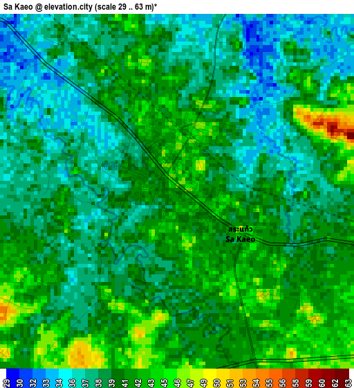
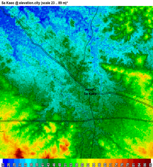
Below is the Elevation map of Sa Kaeo, which displays elevation range with different colors. Scale of the first map is from 29 to 63 m (95 to 207 ft) with average elevation of 39.9 meters (=131 ft) [note 1]
These maps also provides idea of topography and contour of this city, they are displayed at different zoom levels. More info about maps, scale and edge coordinates you can find below images.
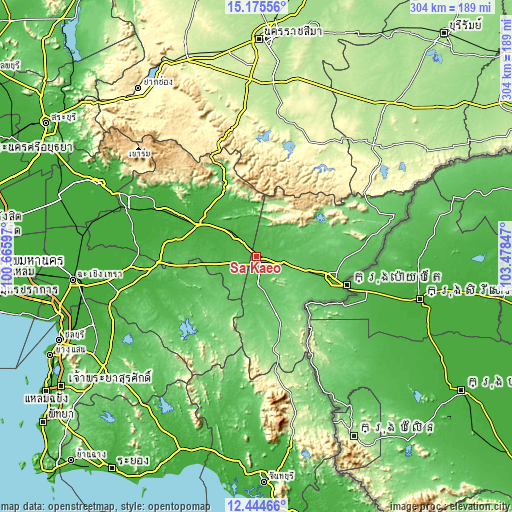
| \ | Map #1 | Map #2 | Topo.Map |
| Scale [m] | 29..63 m | 23..89 m | × |
| Scale [ft] | 95..207 ft | 75..292 ft | × |
| Average | 39.9 m = 131 ft | 44.3 m = 145 ft | × |
| Width | 9.49 km = 5.9 mi | 18.98 km = 11.8 mi | 303.6 km = 188.6 mi |
| Height | 9.49 km = 5.9 mi | 18.98 km = 11.8 mi | 303.7 km = 188.7 mi |
| ↑Max Latitude | 13.85678° | 13.899443° | 15.17556° |
| Latitude at center | 13.81411° | 13.81411° | 13.81411° |
| ↓Min Latitude | 13.771432° | 13.728746° | 12.44466° |
| ← Min Longitude | 102.028275° | 101.984329° | 100.66597° |
| Longitude center | 102.07222° | 102.07222° | 102.07222° |
| →Max Longitude | 102.116165° | 102.160111° | 103.47847° |
Nearby cities:
Cities around Sa Kaeo sort by population:
• Aranyaprathet elevation 48 m
48.3 km,  106°
106°
• Kabin Buri 21 m
41.2 km,  291°
291°
• Wang Nam Yen 112 m
36.5 km,  161°
161°
• Prachamtakham 10 m
66.3 km, 294°
• Tha Takiap 73 m
64.5 km,  230°
230°
• Si Maha Phot 11 m
62.7 km, 285°
• Khok Sung 66 m
59.5 km,  87°
87°
• Wang Sombun 119 m
51.9 km,  165°
165°
• Khlong Hat 150 m
47.1 km,  148°
148°
• Na Di 29 m
45.8 km,  316°
316°
• Watthana Nakhon 75 m
27.7 km, 106°
• Khao Chakan 62 m
17.9 km, 174°
Multilingual:
 En español:
Sa Kaeo elevación 41 m.
 En France:
Sa Kaeo élévation 41 m.


Sources and notes:
- [note 1] Map square and city borders are not equal. Map elevation data is calculated only from area inside that square.
- [src 1] Elevation data from geonames database provided with same terms of usage.
- [src 2] The elevation map of Sa Kaeo is generated using elevation data from NASA's 3 arcsec (90m) resolution SRTM data.
- [src 3] Base (background) map © OpenStreetMap contributors tiles are generated by Geofabrik and OpenTopoMap.
Copyright & License:
This Sa Kaeo Elevation Map is licensed under CC BY-SA. You may reuse any part from this page, if you give a proper credit by linking to this URL:
 More info on terms of use page.