That Phanom elevation
That Phanom (Nakhon Phanom), Thailand elevation is 147 meters and That Phanom elevation in feet is 482 ft above sea level [src 1]. That Phanom is a seat of a second-order administrative division (feature code) with elevation that is 22 meters (72 ft) bigger than average city elevation in Thailand.
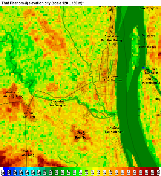
Below is the Elevation map of That Phanom, which displays elevation range with different colors. Scale of the first map is from 120 to 159 m (394 to 522 ft) with average elevation of 142 meters (=466 ft) [note 1]
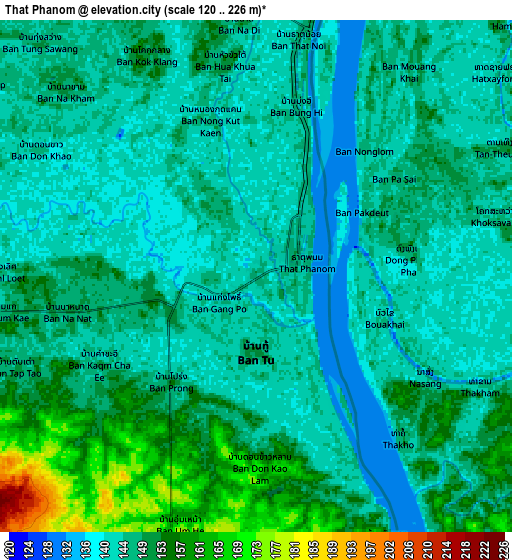
These maps also provides idea of topography and contour of this city, they are displayed at different zoom levels. More info about maps, scale and edge coordinates you can find below images.
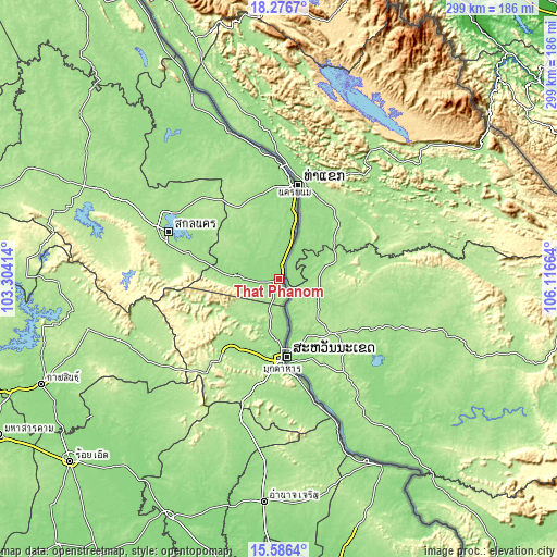
| \ | Map #1 | Map #2 | Topo.Map |
| Scale [m] | 120..159 m | 120..226 m | × |
| Scale [ft] | 394..522 ft | 394..741 ft | × |
| Average | 142 m = 466 ft | 147.4 m = 484 ft | × |
| Width | 9.35 km = 5.8 mi | 18.7 km = 11.6 mi | 299.1 km = 185.9 mi |
| Height | 9.35 km = 5.8 mi | 18.7 km = 11.6 mi | 299.2 km = 185.9 mi |
| ↑Max Latitude | 16.978395° | 17.02042° | 18.2767° |
| Latitude at center | 16.93636° | 16.93636° | 16.93636° |
| ↓Min Latitude | 16.894316° | 16.852263° | 15.5864° |
| ← Min Longitude | 104.666445° | 104.622499° | 103.30414° |
| Longitude center | 104.71039° | 104.71039° | 104.71039° |
| →Max Longitude | 104.754335° | 104.798281° | 106.11664° |
Nearby cities:
Cities around That Phanom sort by population:
• Mukdahan elevation 145 m
43.5 km,  178°
178°
• Nakhon Phanom 154 m
53.2 km,  7°
7°
• Tao Ngoi 183 m
58.2 km,  276°
276°
• Phon Na Kaeo 181 m
54.8 km,  305°
305°
• Khamcha-i 185 m
50.5 km,  217°
217°
• Khok Si Suphan 172 m
47.8 km, 284°
• Pla Pak 166 m
33.5 km,  324°
324°
• Wang Yang 168 m
30.5 km,  296°
296°
• Wan Yai 153 m
24 km,  172°
172°
• Dong Luang 191 m
22.7 km,  233°
233°
• Na Kae 153 m
22.3 km,  272°
272°
• Renu Nakhon 153 m
13.3 km,  344°
344°
Multilingual:
 En español:
That Phanom elevación 147 m.
 En France:
That Phanom élévation 147 m.
 Auf Deutsch:
That Phanom höhe über dem Meeresspiegel ist 147 m.

Sources and notes:
- [note 1] Map square and city borders are not equal. Map elevation data is calculated only from area inside that square.
- [src 1] Elevation data from geonames database provided with same terms of usage.
- [src 2] The elevation map of That Phanom is generated using elevation data from NASA's 3 arcsec (90m) resolution SRTM data.
- [src 3] Base (background) map © OpenStreetMap contributors tiles are generated by Geofabrik and OpenTopoMap.
Copyright & License:
This That Phanom Elevation Map is licensed under CC BY-SA. You may reuse any part from this page, if you give a proper credit by linking to this URL:
 More info on terms of use page.