Wan Yai elevation
Wan Yai (Mukdahan), Thailand elevation is 153 meters and Wan Yai elevation in feet is 502 ft above sea level [src 1]. Wan Yai is a seat of a second-order administrative division (feature code) with elevation that is 28 meters (92 ft) bigger than average city elevation in Thailand.
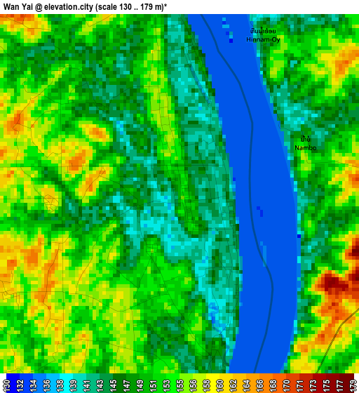
Below is the Elevation map of Wan Yai, which displays elevation range with different colors. Scale of the first map is from 130 to 179 m (427 to 587 ft) with average elevation of 148.1 meters (=486 ft) [note 1]
These maps also provides idea of topography and contour of this city, they are displayed at different zoom levels. More info about maps, scale and edge coordinates you can find below images.
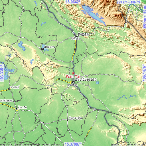
| \ | Map #1 | Topo.Map |
| Scale [m] | 130..179 m | × |
| Scale [ft] | 427..587 ft | × |
| Average | 148.1 m = 486 ft | × |
| Width | 9.36 km = 5.8 mi | 299.5 km = 186.1 mi |
| Height | 9.36 km = 5.8 mi | 299.5 km = 186.1 mi |
| ↑Max Latitude | 16.764372° | 18.0642° |
| Latitude at center | 16.72229° | 16.72229° |
| ↓Min Latitude | 16.680198° | 15.37087° |
| ← Min Longitude | 104.697405° | 103.3351° |
| Longitude center | 104.74135° | 104.74135° |
| →Max Longitude | 104.785295° | 106.1476° |
Nearby cities:
Cities around Wan Yai sort by population:
• Mukdahan elevation 145 m
19.8 km,  185°
185°
• That Phanom 147 m
24 km,  352°
352°
• Loeng Nok Tha 164 m
60.6 km,  199°
199°
• Pla Pak 166 m
55.9 km,  335°
335°
• Nong Sung 198 m
49.7 km,  237°
237°
• Don Tan 159 m
48.9 km,  157°
157°
• Wang Yang 168 m
48.3 km,  320°
320°
• Nikhom Kham Soi 189 m
43.9 km,  207°
207°
• Khamcha-i 185 m
37.9 km, 244°
• Renu Nakhon 153 m
37.2 km, 349°
• Na Kae 153 m
35.7 km,  314°
314°
• Dong Luang 191 m
24 km,  295°
295°
Multilingual:
 En español:
Wan Yai elevación 153 m.
 En France:
Wan Yai élévation 153 m.


Sources and notes:
- [note 1] Map square and city borders are not equal. Map elevation data is calculated only from area inside that square.
- [src 1] Elevation data from geonames database provided with same terms of usage.
- [src 2] The elevation map of Wan Yai is generated using elevation data from NASA's 3 arcsec (90m) resolution SRTM data.
- [src 3] Base (background) map © OpenStreetMap contributors tiles are generated by Geofabrik and OpenTopoMap.
Copyright & License:
This Wan Yai Elevation Map is licensed under CC BY-SA. You may reuse any part from this page, if you give a proper credit by linking to this URL:
 More info on terms of use page.