Mae Hong Son elevation
Mae Hong Son, Thailand elevation is 258 meters and Mae Hong Son elevation in feet is 846 ft above sea level [src 1]. Mae Hong Son is a seat of a first-order administrative division (feature code) with elevation that is 133 meters (436 ft) bigger than average city elevation in Thailand.
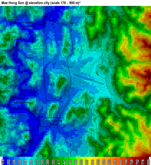
Below is the Elevation map of Mae Hong Son, which displays elevation range with different colors. Scale of the first map is from 178 to 800 m (584 to 2625 ft) with average elevation of 330.7 meters (=1085 ft) [note 1]
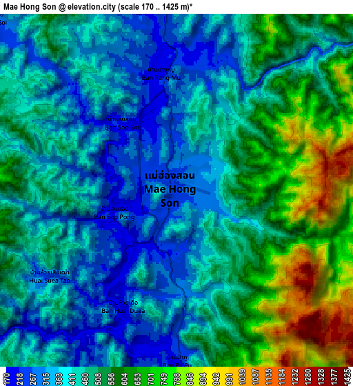
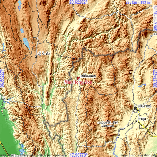
These maps also provides idea of topography and contour of this city, they are displayed at different zoom levels. More info about maps, scale and edge coordinates you can find below images.
| \ | Map #1 | Map #2 | Topo.Map |
| Scale [m] | 178..800 m | 170..1425 m | × |
| Scale [ft] | 584..2625 ft | 558..4675 ft | × |
| Average | 330.7 m = 1085 ft | 469.8 m = 1541 ft | × |
| Width | 9.22 km = 5.7 mi | 18.45 km = 11.5 mi | 295.1 km = 183.4 mi |
| Height | 9.22 km = 5.7 mi | 18.45 km = 11.5 mi | 295.1 km = 183.4 mi |
| ↑Max Latitude | 19.34176° | 19.38322° | 20.62202° |
| Latitude at center | 19.30029° | 19.30029° | 19.30029° |
| ↓Min Latitude | 19.258809° | 19.217318° | 17.96779° |
| ← Min Longitude | 97.924575° | 97.880629° | 96.56227° |
| Longitude center | 97.96852° | 97.96852° | 97.96852° |
| →Max Longitude | 98.012465° | 98.056411° | 99.37477° |
Nearby cities:
Cities around Mae Hong Son sort by population:
• Pai elevation 510 m
49.9 km,  82°
82°
• Chiang Dao 398 m
104.8 km,  86°
86°
• Mae Taeng 336 m
104.2 km,  101°
101°
• Mae La Noi 324 m
102.2 km,  181°
181°
• Mae Chaem 477 m
98.3 km,  154°
154°
• Samoeng 507 m
94.7 km,  122°
122°
• Wiang Haeng 741 m
76.2 km,  68°
68°
• Khun Yuam 620 m
52.5 km, 184°
• Wiang Nuea 522 m
50.9 km, 80°
• Mae Hi 504 m
50.8 km, 84°
• Chaem Luang 940 m
44.9 km,  131°
131°
• Sop Pong 607 m
39.1 km,  51°
51°
Multilingual:
 En español:
Mae Hong Son elevación 258 m.
 En France:
Mae Hong Son élévation 258 m.
 Auf Deutsch:
Mae Hong Son höhe über dem Meeresspiegel ist 258 m.
 На русском:
Мае Хонг Сон, Мэхонгсон высота над уровнем моря 258 м
Sources and notes:
- [note 1] Map square and city borders are not equal. Map elevation data is calculated only from area inside that square.
- [src 1] Elevation data from geonames database provided with same terms of usage.
- [src 2] The elevation map of Mae Hong Son is generated using elevation data from NASA's 3 arcsec (90m) resolution SRTM data.
- [src 3] Base (background) map © OpenStreetMap contributors tiles are generated by Geofabrik and OpenTopoMap.
Copyright & License:
This Mae Hong Son Elevation Map is licensed under CC BY-SA. You may reuse any part from this page, if you give a proper credit by linking to this URL:
 More info on terms of use page.