Mae Sai elevation
Mae Sai (Chiang Rai), Thailand elevation is 437 meters and Mae Sai elevation in feet is 1434 ft above sea level [src 1]. Mae Sai is a seat of a second-order administrative division (feature code) with elevation that is 312 meters (1024 ft) bigger than average city elevation in Thailand.
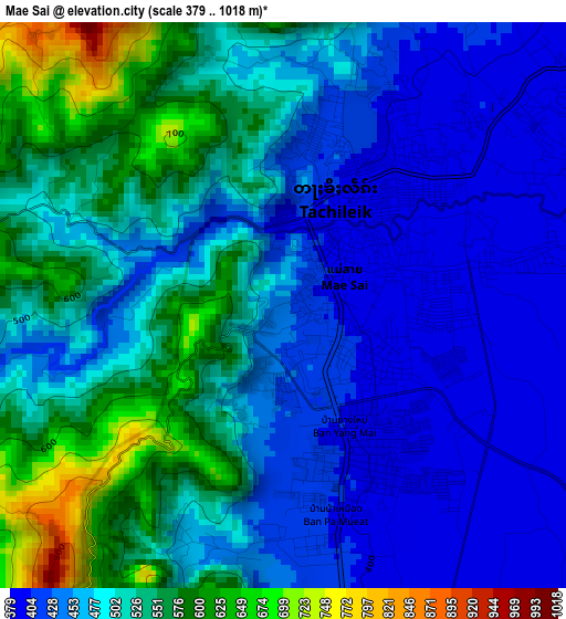
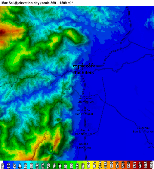
Below is the Elevation map of Mae Sai, which displays elevation range with different colors. Scale of the first map is from 379 to 1018 m (1243 to 3340 ft) with average elevation of 489.4 meters (=1606 ft) [note 1]
These maps also provides idea of topography and contour of this city, they are displayed at different zoom levels. More info about maps, scale and edge coordinates you can find below images.
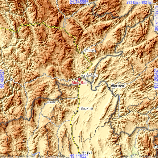
| \ | Map #1 | Map #2 | Topo.Map |
| Scale [m] | 379..1018 m | 369..1509 m | × |
| Scale [ft] | 1243..3340 ft | 1211..4951 ft | × |
| Average | 489.4 m = 1606 ft | 548.5 m = 1800 ft | × |
| Width | 9.16 km = 5.7 mi | 18.32 km = 11.4 mi | 293 km = 182.1 mi |
| Height | 9.16 km = 5.7 mi | 18.32 km = 11.4 mi | 293 km = 182.1 mi |
| ↑Max Latitude | 20.474705° | 20.515868° | 21.74555° |
| Latitude at center | 20.43353° | 20.43353° | 20.43353° |
| ↓Min Latitude | 20.392344° | 20.351148° | 19.11022° |
| ← Min Longitude | 99.832225° | 99.788279° | 98.46992° |
| Longitude center | 99.87617° | 99.87617° | 99.87617° |
| →Max Longitude | 99.920115° | 99.964061° | 101.28242° |
Nearby cities:
Cities around Mae Sai sort by population:
• Chiang Rai elevation 401 m
58.5 km,  184°
184°
• Mae Chan 416 m
32 km, 184°
• Chiang Khong 358 m
58.3 km,  109°
109°
• Chiang Saen 373 m
28.2 km,  128°
128°
• Wiang Kaen 362 m
75.4 km,  118°
118°
• Mae Ai 467 m
75.2 km,  233°
233°
• Mae Lao 451 m
73.9 km,  194°
194°
• Phaya Mengrai 376 m
71.1 km,  155°
155°
• Wiang Chai 399 m
61.4 km,  174°
174°
• Wiang Chiang Rung 389 m
50.4 km, 158°
• Doi Luang 389 m
42.1 km,  146°
146°
• Mae Fa Luang 826 m
20.3 km,  203°
203°
Multilingual:
 En español:
Mae Sai elevación 437 m.
 En France:
Mae Sai élévation 437 m.


Sources and notes:
- [note 1] Map square and city borders are not equal. Map elevation data is calculated only from area inside that square.
- [src 1] Elevation data from geonames database provided with same terms of usage.
- [src 2] The elevation map of Mae Sai is generated using elevation data from NASA's 3 arcsec (90m) resolution SRTM data.
- [src 3] Base (background) map © OpenStreetMap contributors tiles are generated by Geofabrik and OpenTopoMap.
Copyright & License:
This Mae Sai Elevation Map is licensed under CC BY-SA. You may reuse any part from this page, if you give a proper credit by linking to this URL:
 More info on terms of use page.