Chiang Rai elevation
Chiang Rai, Thailand elevation is 401 meters and Chiang Rai elevation in feet is 1316 ft above sea level [src 1]. Chiang Rai is a seat of a first-order administrative division (feature code) with elevation that is 276 meters (906 ft) bigger than average city elevation in Thailand.
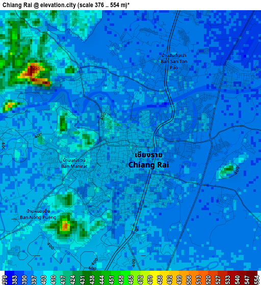
Below is the Elevation map of Chiang Rai, which displays elevation range with different colors. Scale of the first map is from 376 to 554 m (1234 to 1818 ft) with average elevation of 399 meters (=1309 ft) [note 1]
These maps also provides idea of topography and contour of this city, they are displayed at different zoom levels. More info about maps, scale and edge coordinates you can find below images.
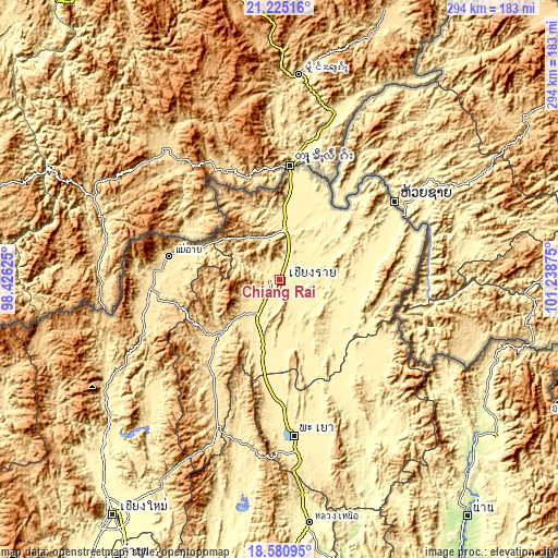
| \ | Map #1 | Map #2 | Topo.Map |
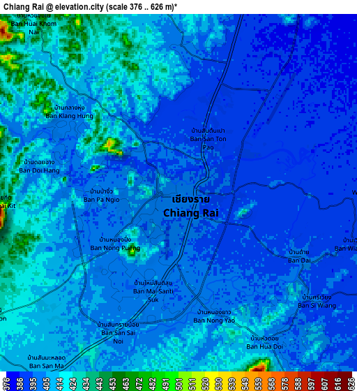
| Scale [m] | 376..554 m | 376..626 m | × |
| Scale [ft] | 1234..1818 ft | 1234..2054 ft | × |
| Average | 399 m = 1309 ft | 404.3 m = 1326 ft | × |
| Width | 9.19 km = 5.7 mi | 18.38 km = 11.4 mi | 294 km = 182.7 mi |
| Height | 9.19 km = 5.7 mi | 18.38 km = 11.4 mi | 294 km = 182.7 mi |
| ↑Max Latitude | 19.949894° | 19.991196° | 21.22516° |
| Latitude at center | 19.90858° | 19.90858° | 19.90858° |
| ↓Min Latitude | 19.867256° | 19.82592° | 18.58095° |
| ← Min Longitude | 99.788555° | 99.744609° | 98.42625° |
| Longitude center | 99.8325° | 99.8325° | 99.8325° |
| →Max Longitude | 99.876445° | 99.920391° | 101.23875° |
Nearby cities:
Cities around Chiang Rai sort by population:
• Mae Chan elevation 416 m
26.6 km,  4°
4°
• Pa Daet 384 m
47.9 km,  159°
159°
• Thoeng 370 m
45.3 km,  123°
123°
• Khun Tan 382 m
45.3 km,  100°
100°
• Mae Suai 460 m
41.2 km,  227°
227°
• Phan 416 m
40.6 km,  193°
193°
• Mae Fa Luang 826 m
39.9 km,  354°
354°
• Doi Luang 389 m
36.3 km,  50°
50°
• Phaya Mengrai 376 m
34.2 km, 101°
• Wiang Chiang Rung 389 m
26.1 km,  63°
63°
• Mae Lao 451 m
19.2 km, 226°
• Wiang Chai 399 m
10.9 km, 104°
Multilingual:
 En español:
Chiang Rai elevación 401 m.
 En France:
Chiang Rai élévation 401 m.
 Auf Deutsch:
Chiang Rai höhe über dem Meeresspiegel ist 401 m.

Sources and notes:
- [note 1] Map square and city borders are not equal. Map elevation data is calculated only from area inside that square.
- [src 1] Elevation data from geonames database provided with same terms of usage.
- [src 2] The elevation map of Chiang Rai is generated using elevation data from NASA's 3 arcsec (90m) resolution SRTM data.
- [src 3] Base (background) map © OpenStreetMap contributors tiles are generated by Geofabrik and OpenTopoMap.
Copyright & License:
This Chiang Rai Elevation Map is licensed under CC BY-SA. You may reuse any part from this page, if you give a proper credit by linking to this URL:
 More info on terms of use page.