Bébédja elevation
Bébédja (Logone Oriental), Chad elevation is 395 meters and Bébédja elevation in feet is 1296 ft above sea level [src 1]. Bébédja is a populated place (feature code) with elevation that is 45 meters (148 ft) smaller than average city elevation in Chad.
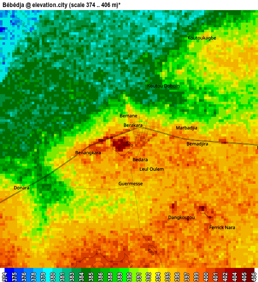
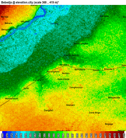
Below is the Elevation map of Bébédja, which displays elevation range with different colors. Scale of the first map is from 374 to 406 m (1227 to 1332 ft) with average elevation of 390.9 meters (=1282 ft) [note 1]
These maps also provides idea of topography and contour of this city, they are displayed at different zoom levels. More info about maps, scale and edge coordinates you can find below images.
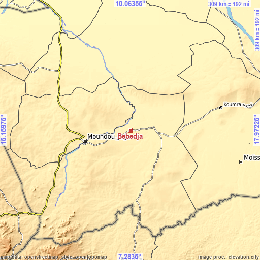
| \ | Map #1 | Map #2 | Topo.Map |
| Scale [m] | 374..406 m | 368..419 m | × |
| Scale [ft] | 1227..1332 ft | 1207..1375 ft | × |
| Average | 390.9 m = 1282 ft | 391.7 m = 1285 ft | × |
| Width | 9.66 km = 6 mi | 19.32 km = 12 mi | 309.1 km = 192.1 mi |
| Height | 9.66 km = 6 mi | 19.32 km = 12 mi | 309.1 km = 192.1 mi |
| ↑Max Latitude | 8.71954° | 8.762975° | 10.06355° |
| Latitude at center | 8.6761° | 8.6761° | 8.6761° |
| ↓Min Latitude | 8.632655° | 8.589205° | 7.2835° |
| ← Min Longitude | 16.522055° | 16.478109° | 15.15975° |
| Longitude center | 16.566° | 16.566° | 16.566° |
| →Max Longitude | 16.609945° | 16.653891° | 17.97225° |
Nearby cities:
Cities around Bébédja sort by population:
• Moundou elevation 401 m
54.4 km,  257°
257°
• Kelo 375 m
109.1 km,  310°
310°
• Koumra 399 m
111.7 km,  76°
76°
• Doba 379 m
31.4 km,  95°
95°
• Laï 363 m
85.3 km,  340°
340°
• Benoy 417 m
43.6 km,  321°
321°
• Béré 361 m
84.6 km,  327°
327°
• Moïssala 385 m
137.2 km,  105°
105°
• Goundi 377 m
116.4 km,  49°
49°
• Gounou Gaya 345 m
156.8 km, 312°
• Beïnamar 450 m
130.2 km,  269°
269°
• Béboto 437 m
61.3 km,  137°
137°
Multilingual:
 En español:
Bébédja elevación 395 m.
 En France:
Bebiya, Bebeidjia, Bebeidja élévation 395 m.


Sources and notes:
- [note 1] Map square and city borders are not equal. Map elevation data is calculated only from area inside that square.
- [src 1] Elevation data from geonames database provided with same terms of usage.
- [src 2] The elevation map of Bébédja is generated using elevation data from NASA's 3 arcsec (90m) resolution SRTM data.
- [src 3] Base (background) map © OpenStreetMap contributors tiles are generated by Geofabrik and OpenTopoMap.
Copyright & License:
This Bébédja Elevation Map is licensed under CC BY-SA. You may reuse any part from this page, if you give a proper credit by linking to this URL:
 More info on terms of use page.