Beïnamar elevation
Beïnamar (Logone Occidental), Chad elevation is 450 meters and Beïnamar elevation in feet is 1476 ft above sea level [src 1]. Beïnamar is a populated place (feature code) with elevation that is 10 meters (33 ft) bigger than average city elevation in Chad.
Below is the Elevation map of Beïnamar, which displays elevation range with different colors. Scale of the first map is from 416 to 512 m (1365 to 1680 ft) with average elevation of 458.6 meters (=1505 ft) [note 1]
These maps also provides idea of topography and contour of this city, they are displayed at different zoom levels. More info about maps, scale and edge coordinates you can find below images.
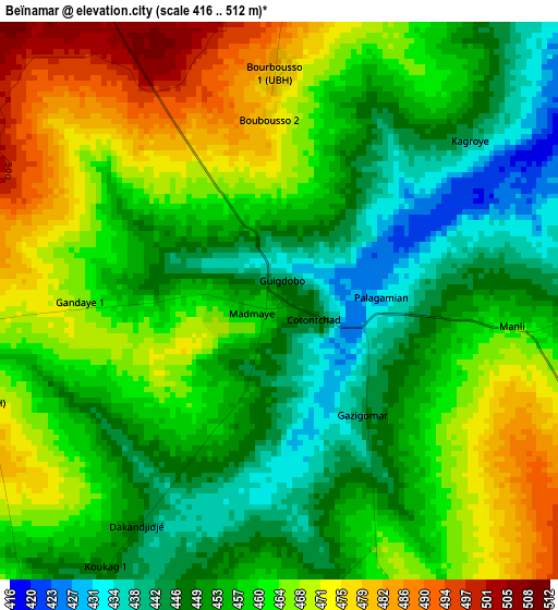
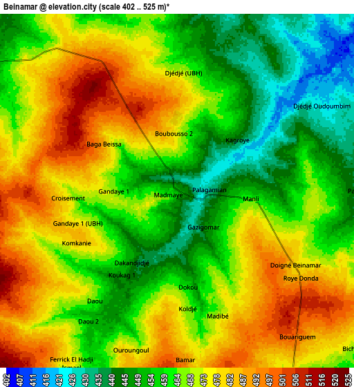
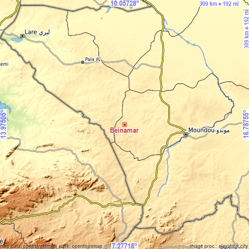
| \ | Map #1 | Map #2 | Topo.Map |
| Scale [m] | 416..512 m | 402..525 m | × |
| Scale [ft] | 1365..1680 ft | 1319..1722 ft | × |
| Average | 458.6 m = 1505 ft | 466.4 m = 1530 ft | × |
| Width | 9.66 km = 6 mi | 19.32 km = 12 mi | 309.1 km = 192.1 mi |
| Height | 9.66 km = 6 mi | 19.32 km = 12 mi | 309.1 km = 192.1 mi |
| ↑Max Latitude | 8.713241° | 8.756676° | 10.05728° |
| Latitude at center | 8.6698° | 8.6698° | 8.6698° |
| ↓Min Latitude | 8.626354° | 8.582904° | 7.27718° |
| ← Min Longitude | 15.337355° | 15.293409° | 13.97505° |
| Longitude center | 15.3813° | 15.3813° | 15.3813° |
| →Max Longitude | 15.425245° | 15.469191° | 16.78755° |
Nearby cities:
Cities around Beïnamar sort by population:
• Moundou elevation 401 m
78 km,  98°
98°
• Kelo 375 m
85 km,  33°
33°
• Pala 433 m
93.3 km,  325°
325°
• Bongor 334 m
179.1 km,  359°
359°
• Doba 379 m
161.5 km,  90°
90°
• Laï 363 m
129.4 km,  51°
51°
• Mboursou Léré 287 m
181.5 km,  312°
312°
• Benoy 417 m
108.9 km,  71°
71°
• Béré 361 m
111.6 km, 49°
• Bébédja 395 m
130.2 km, 89°
• Gounou Gaya 345 m
107.7 km,  7°
7°
• Béboto 437 m
177.1 km, 104°
Multilingual:
 En español:
Beïnamar elevación 450 m.
 En France:
Beïnamar élévation 450 m.
 Auf Deutsch:
Beïnamar höhe über dem Meeresspiegel ist 450 m.

Sources and notes:
- [note 1] Map square and city borders are not equal. Map elevation data is calculated only from area inside that square.
- [src 1] Elevation data from geonames database provided with same terms of usage.
- [src 2] The elevation map of Beïnamar is generated using elevation data from NASA's 3 arcsec (90m) resolution SRTM data.
- [src 3] Base (background) map © OpenStreetMap contributors tiles are generated by Geofabrik and OpenTopoMap.
Copyright & License:
This Beïnamar Elevation Map is licensed under CC BY-SA. You may reuse any part from this page, if you give a proper credit by linking to this URL:
 More info on terms of use page.