Big Bend elevation
Big Bend (Lubombo), Eswatini elevation is 109 meters and Big Bend elevation in feet is 358 ft above sea level [src 1]. Big Bend is a populated place (feature code) with elevation that is 570 meters (1870 ft) smaller than average city elevation in Eswatini.
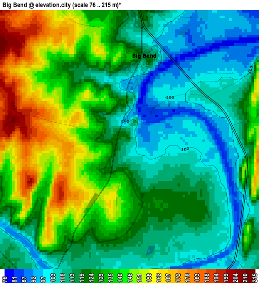
Below is the Elevation map of Big Bend, which displays elevation range with different colors. Scale of the first map is from 76 to 215 m (249 to 705 ft) with average elevation of 125.6 meters (=412 ft) [note 1]
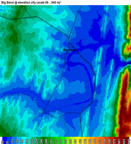
These maps also provides idea of topography and contour of this city, they are displayed at different zoom levels. More info about maps, scale and edge coordinates you can find below images.
| \ | Map #1 | Map #2 | Topo.Map |
| Scale [m] | 76..215 m | 69..645 m | × |
| Scale [ft] | 249..705 ft | 226..2116 ft | × |
| Average | 125.6 m = 412 ft | 171.1 m = 561 ft | × |
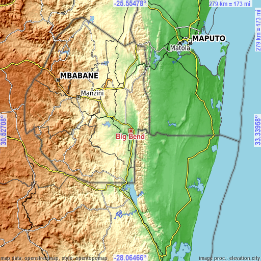
| Width | 8.72 km = 5.4 mi | 17.44 km = 10.8 mi | 279.1 km = 173.4 mi |
| Height | 8.72 km = 5.4 mi | 17.44 km = 10.8 mi | 279.1 km = 173.4 mi |
| ↑Max Latitude | -26.777444° | -26.738204° | -25.55478° |
| Latitude at center | -26.81667° | -26.81667° | -26.81667° |
| ↓Min Latitude | -26.855882° | -26.895081° | -28.06466° |
| ← Min Longitude | 31.889385° | 31.845439° | 30.52708° |
| Longitude center | 31.93333° | 31.93333° | 31.93333° |
| →Max Longitude | 31.977275° | 32.021221° | 33.33958° |
Nearby cities:
Cities around Big Bend sort by population:
• Manzini elevation 601 m
65.4 km,  302°
302°
• Malkerns 684 m
79.5 km,  290°
290°
• Nhlangano 1075 m
79.9 km,  245°
245°
• Hluti 530 m
54.4 km,  215°
215°
• Siteki 605 m
40.5 km,  1°
1°
• Lobamba 694 m
82.6 km, 298°
• Kwaluseni 677 m
70.2 km, 301°
• Hlatikulu 1149 m
63 km, 253°
• Kubuta 490 m
45.3 km,  260°
260°
• Lavumisa 178 m
55 km,  184°
184°
• Sidvokodvo 375 m
55.1 km, 292°
• Nsoko 178 m
24.1 km, 176°
Multilingual:
 En español:
Big Bend elevación 109 m.
 En France:
Big Bend élévation 109 m.
 Auf Deutsch:
Big Bend höhe über dem Meeresspiegel ist 109 m.

Sources and notes:
- [note 1] Map square and city borders are not equal. Map elevation data is calculated only from area inside that square.
- [src 1] Elevation data from geonames database provided with same terms of usage.
- [src 2] The elevation map of Big Bend is generated using elevation data from NASA's 3 arcsec (90m) resolution SRTM data.
- [src 3] Base (background) map © OpenStreetMap contributors tiles are generated by Geofabrik and OpenTopoMap.
Copyright & License:
This Big Bend Elevation Map is licensed under CC BY-SA. You may reuse any part from this page, if you give a proper credit by linking to this URL:
 More info on terms of use page.