Manzini elevation
Manzini, Eswatini elevation is 601 meters and Manzini elevation in feet is 1972 ft above sea level [src 1]. Manzini is a seat of a first-order administrative division (feature code) with elevation that is 78 meters (256 ft) smaller than average city elevation in Eswatini.
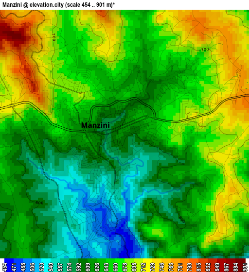
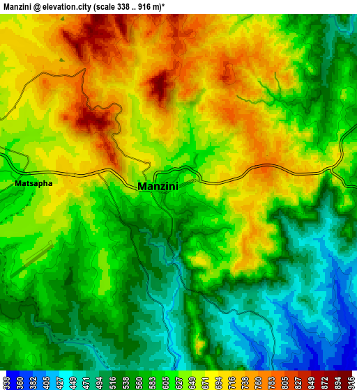
Below is the Elevation map of Manzini, which displays elevation range with different colors. Scale of the first map is from 454 to 901 m (1490 to 2956 ft) with average elevation of 645.1 meters (=2116 ft) [note 1]
These maps also provides idea of topography and contour of this city, they are displayed at different zoom levels. More info about maps, scale and edge coordinates you can find below images.
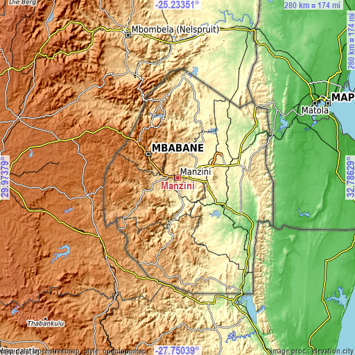
| \ | Map #1 | Map #2 | Topo.Map |
| Scale [m] | 454..901 m | 338..916 m | × |
| Scale [ft] | 1490..2956 ft | 1109..3005 ft | × |
| Average | 645.1 m = 2116 ft | 612.3 m = 2009 ft | × |
| Width | 8.75 km = 5.4 mi | 17.49 km = 10.9 mi | 279.9 km = 173.9 mi |
| Height | 8.75 km = 5.4 mi | 17.49 km = 10.9 mi | 279.9 km = 173.9 mi |
| ↑Max Latitude | -26.459505° | -26.420156° | -25.23351° |
| Latitude at center | -26.49884° | -26.49884° | -26.49884° |
| ↓Min Latitude | -26.538162° | -26.57747° | -27.75039° |
| ← Min Longitude | 31.336095° | 31.292149° | 29.97379° |
| Longitude center | 31.38004° | 31.38004° | 31.38004° |
| →Max Longitude | 31.423985° | 31.467931° | 32.78629° |
Nearby cities:
Cities around Manzini sort by population:
• Mbabane elevation 1209 m
31.8 km,  309°
309°
• Malkerns 684 m
21 km,  248°
248°
• Siteki 605 m
56.7 km,  84°
84°
• Piggs Peak 1018 m
61.3 km,  347°
347°
• Lobamba 694 m
18.3 km,  281°
281°
• Kwaluseni 677 m
5 km,  290°
290°
• Bhunya 956 m
36.6 km,  261°
261°
• Mhlambanyatsi 1317 m
36.6 km, 278°
• Hlatikulu 1149 m
53.7 km,  185°
185°
• Kubuta 490 m
44 km,  166°
166°
• Sidvokodvo 375 m
14.9 km,  164°
164°
• Darkton 1308 m
45.4 km, 310°
Multilingual:
 En español:
Manzini elevación 601 m.
 En France:
Manzini élévation 601 m.


Sources and notes:
- [note 1] Map square and city borders are not equal. Map elevation data is calculated only from area inside that square.
- [src 1] Elevation data from geonames database provided with same terms of usage.
- [src 2] The elevation map of Manzini is generated using elevation data from NASA's 3 arcsec (90m) resolution SRTM data.
- [src 3] Base (background) map © OpenStreetMap contributors tiles are generated by Geofabrik and OpenTopoMap.
Copyright & License:
This Manzini Elevation Map is licensed under CC BY-SA. You may reuse any part from this page, if you give a proper credit by linking to this URL:
 More info on terms of use page.