Mbabane elevation
Mbabane (Hhohho), Eswatini elevation is 1209 meters and Mbabane elevation in feet is 3967 ft above sea level [src 1]. Mbabane is a capital of a political entity (feature code) with elevation that is 530 meters (1739 ft) bigger than average city elevation in Eswatini.
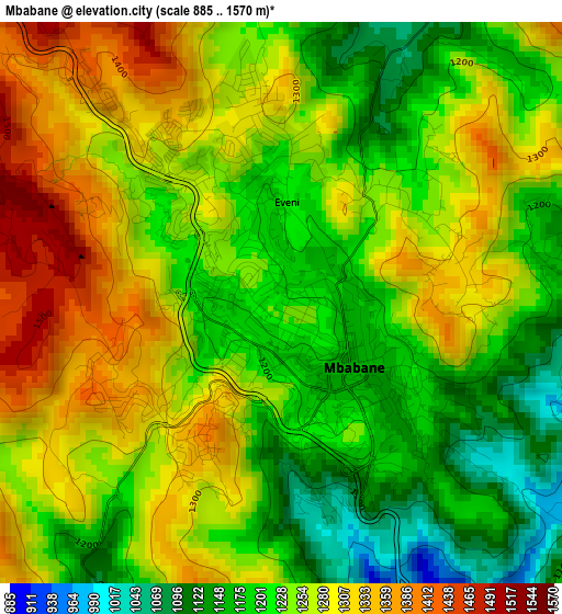
Below is the Elevation map of Mbabane, which displays elevation range with different colors. Scale of the first map is from 885 to 1570 m (2904 to 5151 ft) with average elevation of 1245.5 meters (=4086 ft) [note 1]
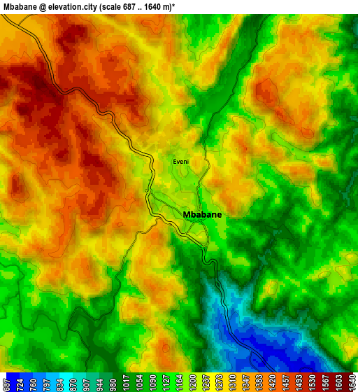
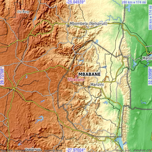
These maps also provides idea of topography and contour of this city, they are displayed at different zoom levels. More info about maps, scale and edge coordinates you can find below images.
| \ | Map #1 | Map #2 | Topo.Map |
| Scale [m] | 885..1570 m | 687..1640 m | × |
| Scale [ft] | 2904..5151 ft | 2254..5381 ft | × |
| Average | 1245.5 m = 4086 ft | 1219 m = 3999 ft | × |
| Width | 8.76 km = 5.4 mi | 17.52 km = 10.9 mi | 280.3 km = 174.2 mi |
| Height | 8.76 km = 5.4 mi | 17.52 km = 10.9 mi | 280.3 km = 174.2 mi |
| ↑Max Latitude | -26.277273° | -26.237862° | -25.04939° |
| Latitude at center | -26.31667° | -26.31667° | -26.31667° |
| ↓Min Latitude | -26.356054° | -26.395425° | -27.57024° |
| ← Min Longitude | 31.089385° | 31.045439° | 29.72708° |
| Longitude center | 31.13333° | 31.13333° | 31.13333° |
| →Max Longitude | 31.177275° | 31.221221° | 32.53958° |
Nearby cities:
Cities around Mbabane sort by population:
• Manzini elevation 601 m
31.8 km,  129°
129°
• Malkerns 684 m
28.2 km,  169°
169°
• Piggs Peak 1018 m
41.2 km,  15°
15°
• Lobamba 694 m
18 km,  158°
158°
• Kwaluseni 677 m
27.2 km, 132°
• Bhunya 956 m
28.4 km,  204°
204°
• Mhlambanyatsi 1317 m
18.8 km,  218°
218°
• Bulembu 1078 m
38.9 km,  0°
0°
• Tshaneni 292 m
69 km,  57°
57°
• Sidvokodvo 375 m
44.9 km,  140°
140°
• Darkton 1308 m
13.6 km,  312°
312°
• Ntfonjeni 552 m
57.8 km, 19°
Multilingual:
 En español:
Mbabane elevación 1209 m.
 En France:
Mbabane élévation 1209 m.
 Auf Deutsch:
Mbabane höhe über dem Meeresspiegel ist 1209 m.

Sources and notes:
- [note 1] Map square and city borders are not equal. Map elevation data is calculated only from area inside that square.
- [src 1] Elevation data from geonames database provided with same terms of usage.
- [src 2] The elevation map of Mbabane is generated using elevation data from NASA's 3 arcsec (90m) resolution SRTM data.
- [src 3] Base (background) map © OpenStreetMap contributors tiles are generated by Geofabrik and OpenTopoMap.
Copyright & License:
This Mbabane Elevation Map is licensed under CC BY-SA. You may reuse any part from this page, if you give a proper credit by linking to this URL:
 More info on terms of use page.