Jisr ash Shughūr elevation
Jisr ash Shughūr (Idlib), Syria elevation is 163 meters and Jisr ash Shughūr elevation in feet is 535 ft above sea level [src 1]. Jisr ash Shughūr is a seat of a second-order administrative division (feature code) with elevation that is 366 meters (1201 ft) smaller than average city elevation in Syria.
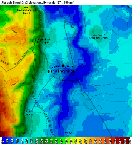
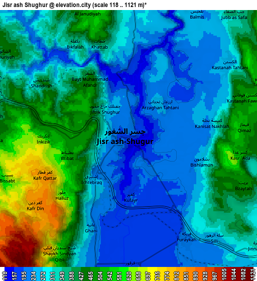
Below is the Elevation map of Jisr ash Shughūr, which displays elevation range with different colors. Scale of the first map is from 127 to 690 m (417 to 2264 ft) with average elevation of 267.4 meters (=877 ft) [note 1]
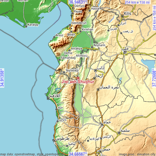
These maps also provides idea of topography and contour of this city, they are displayed at different zoom levels. More info about maps, scale and edge coordinates you can find below images.
| \ | Map #1 | Map #2 | Topo.Map |
| Scale [m] | 127..690 m | 118..1121 m | × |
| Scale [ft] | 417..2264 ft | 387..3678 ft | × |
| Average | 267.4 m = 877 ft | 361.7 m = 1187 ft | × |
| Width | 7.92 km = 4.9 mi | 15.85 km = 9.8 mi | 253.6 km = 157.6 mi |
| Height | 7.92 km = 4.9 mi | 15.85 km = 9.8 mi | 253.6 km = 157.6 mi |
| ↑Max Latitude | 35.849808° | 35.88542° | 36.94631° |
| Latitude at center | 35.81418° | 35.81418° | 35.81418° |
| ↓Min Latitude | 35.778536° | 35.742876° | 34.66567° |
| ← Min Longitude | 36.275885° | 36.231939° | 34.91358° |
| Longitude center | 36.31983° | 36.31983° | 36.31983° |
| →Max Longitude | 36.363775° | 36.407721° | 37.72608° |
Nearby cities:
Cities around Jisr ash Shughūr sort by population:
• Idlib elevation 442 m
31.1 km,  65°
65°
• Kafranbel 643 m
31.4 km,  135°
135°
• Şlinfah 1123 m
26.8 km,  206°
206°
• Arīḩā 598 m
26.1 km,  90°
90°
• Rabī‘ah 576 m
25.6 km,  263°
263°
• Iḩsim 762 m
23.7 km,  115°
115°
• Darkūsh 109 m
20.8 km,  18°
18°
• Kinnsibbā 661 m
16.1 km,  240°
240°
• Az Ziyārah 172 m
14.5 km,  173°
173°
• Muḩambal 370 m
14.1 km,  102°
102°
• Bdāmā 434 m
11.1 km,  268°
268°
• Al Jānūdīyah 518 m
8.3 km,  341°
341°
Multilingual:
 En español:
Jisr ash Shughūr elevación 163 m.
 En France:
Jisr ash Shughūr élévation 163 m.
 Auf Deutsch:
Jisr ash Shughūr höhe über dem Meeresspiegel ist 163 m.

Sources and notes:
- [note 1] Map square and city borders are not equal. Map elevation data is calculated only from area inside that square.
- [src 1] Elevation data from geonames database provided with same terms of usage.
- [src 2] The elevation map of Jisr ash Shughūr is generated using elevation data from NASA's 3 arcsec (90m) resolution SRTM data.
- [src 3] Base (background) map © OpenStreetMap contributors tiles are generated by Geofabrik and OpenTopoMap.
Copyright & License:
This Jisr ash Shughūr Elevation Map is licensed under CC BY-SA. You may reuse any part from this page, if you give a proper credit by linking to this URL:
 More info on terms of use page.