Salqīn elevation
Salqīn (Idlib), Syria elevation is 370 meters and Salqīn elevation in feet is 1214 ft above sea level [src 1]. Salqīn is a seat of a third-order administrative division (feature code) with elevation that is 159 meters (522 ft) smaller than average city elevation in Syria.
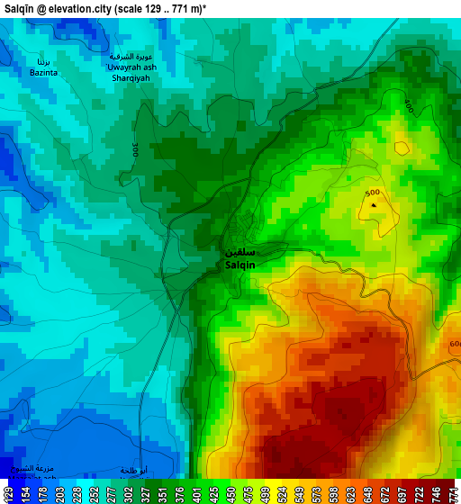
Below is the Elevation map of Salqīn, which displays elevation range with different colors. Scale of the first map is from 129 to 771 m (423 to 2530 ft) with average elevation of 371.3 meters (=1218 ft) [note 1]
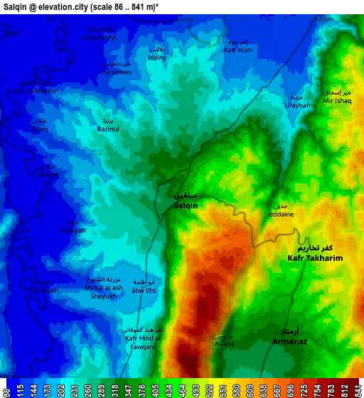
These maps also provides idea of topography and contour of this city, they are displayed at different zoom levels. More info about maps, scale and edge coordinates you can find below images.
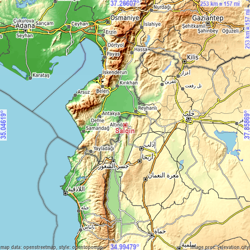
| \ | Map #1 | Map #2 | Topo.Map |
| Scale [m] | 129..771 m | 86..841 m | × |
| Scale [ft] | 423..2530 ft | 282..2759 ft | × |
| Average | 371.3 m = 1218 ft | 297.3 m = 975 ft | × |
| Width | 7.89 km = 4.9 mi | 15.78 km = 9.8 mi | 252.5 km = 156.9 mi |
| Height | 7.89 km = 4.9 mi | 15.78 km = 9.8 mi | 252.5 km = 156.9 mi |
| ↑Max Latitude | 36.174132° | 36.209598° | 37.26607° |
| Latitude at center | 36.13865° | 36.13865° | 36.13865° |
| ↓Min Latitude | 36.103152° | 36.067638° | 34.99479° |
| ← Min Longitude | 36.408495° | 36.364549° | 35.04619° |
| Longitude center | 36.45244° | 36.45244° | 36.45244° |
| →Max Longitude | 36.496385° | 36.540331° | 37.85869° |
Nearby cities:
Cities around Salqīn sort by population:
• Idlib elevation 442 m
28.3 km,  144°
144°
• Ma‘arratmişrīn 339 m
24.3 km,  125°
125°
• Binnish 363 m
31 km, 130°
• Kafr Takhārīm 469 m
6.1 km,  113°
113°
• Ad Dānā 400 m
29.7 km,  73°
73°
• Taftanāz 329 m
33.8 km,  117°
117°
• Al Atārib 311 m
33.5 km,  89°
89°
• Al Jānūdīyah 518 m
31.7 km,  207°
207°
• Darkūsh 109 m
17.2 km,  197°
197°
• Qarqania 541 m
14.4 km, 90°
• Ḩārim 173 m
10.2 km,  37°
37°
• Armanāz 336 m
7.6 km, 143°
Multilingual:
 En español:
Salqīn elevación 370 m.
 En France:
Salqīn élévation 370 m.


Sources and notes:
- [note 1] Map square and city borders are not equal. Map elevation data is calculated only from area inside that square.
- [src 1] Elevation data from geonames database provided with same terms of usage.
- [src 2] The elevation map of Salqīn is generated using elevation data from NASA's 3 arcsec (90m) resolution SRTM data.
- [src 3] Base (background) map © OpenStreetMap contributors tiles are generated by Geofabrik and OpenTopoMap.
Copyright & License:
This Salqīn Elevation Map is licensed under CC BY-SA. You may reuse any part from this page, if you give a proper credit by linking to this URL:
 More info on terms of use page.